86.107.58.180 - IP Lookup: Free IP Address Lookup, Postal Code Lookup, IP Location Lookup, IP ASN, Public IP
Country:
Region:
City:
Location:
Time Zone:
Postal Code:
ISP:
ASN:
language:
User-Agent:
Proxy IP:
Blacklist:
IP information under different IP Channel
ip-api
Country
Region
City
ASN
Time Zone
ISP
Blacklist
Proxy
Latitude
Longitude
Postal
Route
db-ip
Country
Region
City
ASN
Time Zone
ISP
Blacklist
Proxy
Latitude
Longitude
Postal
Route
IPinfo
Country
Region
City
ASN
Time Zone
ISP
Blacklist
Proxy
Latitude
Longitude
Postal
Route
IP2Location
86.107.58.180Country
Region
arges
City
curtea de arges
Time Zone
Europe/Bucharest
ISP
Language
User-Agent
Latitude
Longitude
Postal
ipdata
Country
Region
City
ASN
Time Zone
ISP
Blacklist
Proxy
Latitude
Longitude
Postal
Route
Popular places and events near this IP address

Curtea de Argeș
Municipality in Argeș, Romania
Distance: Approx. 729 meters
Latitude and longitude: 45.13916667,24.67916667
Curtea de Argeș (Romanian pronunciation: [ˈkurte̯a de ˈardʒeʃ] ) is a city in Romania on the left bank of the river Argeș, where it flows through a valley of the Southern Carpathians (the Făgăraș Mountains), on the railway from Pitești to the Turnu Roșu Pass. It is part of Argeș County. The city also administers one village, Noapteș.

Curtea de Argeș Cathedral
Romanian Orthodox cathedral in Argeș, Romania
Distance: Approx. 2706 meters
Latitude and longitude: 45.15694444,24.67527778
The Cathedral of Curtea de Argeș (early 16th century) is a Romanian Orthodox cathedral in Curtea de Argeș, Romania. It is located on the grounds of the Curtea de Argeș Monastery, and is dedicated to Dormition of the Mother of God. The building is the seat of the Archdiocese of Argeș and Muscel.
Albeștii de Argeș
Commune in Argeș, Romania
Distance: Approx. 9372 meters
Latitude and longitude: 45.21666667,24.66666667
Albeștii de Argeș is a commune in Argeș County, Muntenia, Romania. It is composed of seven villages: Albeștii Pământeni (the commune centre), Albeștii Ungureni, Brătești, Doblea, Dobrotu, Dumirești, and Florieni.
Bănești (Argeș)
River in Argeș County, Romania
Distance: Approx. 9839 meters
Latitude and longitude: 45.2191,24.6532
The Bănești or Cicănești is a right tributary of the river Argeș in Romania. It flows into the Argeș in Dobrotu. Its length is 14 km (8.7 mi) and its basin size is 39 km2 (15 sq mi).
Valea Danului (river)
River in Argeș County, Romania
Distance: Approx. 4090 meters
Latitude and longitude: 45.1666,24.6613
The Valea Danului is a right tributary of the river Argeș in Romania. It flows into the Argeș near Curtea de Argeș. Its length is 11 km (6.8 mi) and its basin size is 28 km2 (11 sq mi).
Valea Iașului (river)
River in Argeș County, Romania
Distance: Approx. 2550 meters
Latitude and longitude: 45.1542,24.67
The Valea Iașului is a left tributary of the river Argeș in Romania. It flows into the Argeș in Curtea de Argeș. Its length is 12 km (7.5 mi) and its basin size is 34 km2 (13 sq mi).

Băiculești
Commune in Argeș, Romania
Distance: Approx. 7533 meters
Latitude and longitude: 45.06666667,24.7
Băiculești is a commune in Argeș County, Muntenia, Romania. It is composed of ten villages: Alunișu, Anghinești, Argeșani, Băiculești, Mănicești, Stejari, Tutana, Valea Brazilor, Valea lui Enache, and Zigoneni.
Mușătești
Commune in Argeș, Romania
Distance: Approx. 9959 meters
Latitude and longitude: 45.1889,24.7827
Mușătești is a commune in Argeș County, Muntenia, Romania. It is composed of nine villages: Bolovănești, Costești-Vâlsan, Mușătești, Prosia, Robaia, Stroești, Valea Faurului, Valea Muscelului and Vâlsănești.
Valea Danului
Commune in Argeș, Romania
Distance: Approx. 6153 meters
Latitude and longitude: 45.18333333,24.65
Valea Danului is a commune in Argeș County, Muntenia, Romania. It is composed of five villages: Bănicești, Bolculești, Borobănești, Valea Danului, and Vernești. The commune is situated in the southern foothills of the Făgăraș Mountains, at an altitude of 481 m (1,578 ft), on the banks of the Valea Danului River.

Valea Iașului
Commune in Argeș, Romania
Distance: Approx. 6155 meters
Latitude and longitude: 45.18333333,24.71666667
Valea Iașului is a commune in Argeș County, Muntenia, Romania. It is composed of nine villages: Bădila, Bărbălătești, Borovinești, Cerbureni, Mustățești, Ruginoasa, Ungureni, Valea Iașului, and Valea Uleiului.

Stadionul Municipal (Curtea de Argeș)
Distance: Approx. 1729 meters
Latitude and longitude: 45.1471,24.6732
Municipal Stadium is a multi-use stadium in Curtea de Argeș, Romania. It serves mostly for football matches and had been the home ground of Internaţional Curtea de Argeş. The stadium holds up to 7,500 people.

Princely Church of Saint Nicholas, Curtea de Argeș
Distance: Approx. 5 meters
Latitude and longitude: 45.13333333,24.68333333
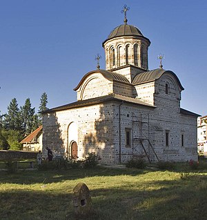
The Princely Church of Saint Nicholas in Curtea de Argeș was founded by Basarab I (1310 - 1352), completed in 1352, in the perimeter of the 13th century voievodal court. The church, a complex inscribed Greek cross monument, is one of the most representative monuments of medieval Romanian architecture, being the oldest voivode funded religious monument in Wallachia. The interior murals are from 1364 - 1369.
Weather in this IP's area
clear sky
-5 Celsius
-5 Celsius
-5 Celsius
-5 Celsius
1031 hPa
77 %
1031 hPa
974 hPa
10000 meters
1.07 m/s
0.84 m/s
297 degree
4 %
