Country:
 France
Region:
City:
Latitude and Longitude:
Time Zone:
Postal Code:
IP information under different IP Channel
ip-api
Country
Region
City
ASN
Time Zone
ISP
Blacklist
Proxy
Latitude
Longitude
Postal
Route
IPinfo
Country
Region
City
ASN
Time Zone
ISP
Blacklist
Proxy
Latitude
Longitude
Postal
Route
MaxMind
Country
Region
City
ASN
Time Zone
ISP
Blacklist
Proxy
Latitude
Longitude
Postal
Route
Luminati
Country
FRRegion
hdf
City
marly
ASN
Time Zone
Europe/Paris
ISP
Techcrea Solutions SAS
Latitude
Longitude
Postal
db-ip
Country
Region
City
ASN
Time Zone
ISP
Blacklist
Proxy
Latitude
Longitude
Postal
Route
ipdata
Country
Region
City
ASN
Time Zone
ISP
Blacklist
Proxy
Latitude
Longitude
Postal
Route
Popular places and events near this IP address

Valenciennes
Subprefecture and commune in Hauts-de-France, France
Distance: Approx. 2273 meters
Latitude and longitude: 50.35805556,3.52333333
Valenciennes (, also UK: , US: , French: [valɑ̃sjɛn] ; also Dutch: Valencijn; Picard: Valincyinnes or Valinciennes; Latin: Valentianae) is a commune in the Nord department, Hauts-de-France, France. It lies on the Scheldt (French: Escaut) river. Although the city and region experienced a steady population decline between 1975 and 1990, it has since rebounded.
Stade Nungesser
Distance: Approx. 1794 meters
Latitude and longitude: 50.348925,3.526847
Stade Nungesser was a multi-use stadium in Valenciennes, France. It is currently used mostly for football matches and was the home stadium of Valenciennes FC through the 2010–11 season. The stadium is able to hold 16,457 people and was built in 1930.
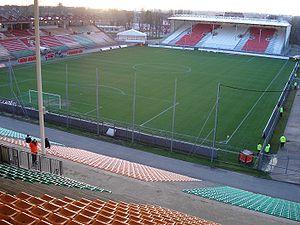
Stade du Hainaut
Stadium in Valenciennes, France
Distance: Approx. 1458 meters
Latitude and longitude: 50.34838889,3.53161111
The Stade du Hainaut is a multi-use stadium in Valenciennes, France. It is used mostly for football matches and hosts the home matches of Valenciennes FC. It has replaced the Stade Nungesser as VAFC's home stadium. The stadium has a capacity of 25,172 spectators for football matches, but its capacity can be extended to 35,000 for concerts.
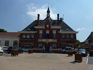
Marly, Nord
Commune in Hauts-de-France, France
Distance: Approx. 504 meters
Latitude and longitude: 50.349,3.545
Marly (French pronunciation: [maʁli]) is a commune in the Nord department in northern France. It is 3 km (1.9 mi) southeast of Valenciennes.

Saint-Saulve
Commune in Hauts-de-France, France
Distance: Approx. 2336 meters
Latitude and longitude: 50.37,3.555
Saint-Saulve (French pronunciation: [sɛ̃ solv]) is a commune in the Nord department in northern France. The town is named after Saint Salvius of Amiens (died c. 615), a bishop of Amiens.

Saultain
Commune in Hauts-de-France, France
Distance: Approx. 2100 meters
Latitude and longitude: 50.338,3.576
Saultain (French pronunciation: [soltɛ̃]) is a commune in the Nord department in northern France.

Siege of Valenciennes (1676–1677)
French victory in the Franco-Dutch War
Distance: Approx. 2273 meters
Latitude and longitude: 50.35805556,3.52333333
The siege of Valenciennes took place from 28 February to 17 March 1677, during the Franco-Dutch War, when Valenciennes, then in the Spanish Netherlands, was attacked by a French army under the duc de Luxembourg. Over the winter of 1676 to 1677, Valenciennes and Cambrai were subjected to a tight blockade, which prevented reinforcements or supplies reaching them from the outside. French armies also benefitted from superior logistics, which allowed them to begin campaigns far earlier than their opponents.

Battle of Valenciennes (1656)
1656 battle during the Franco-Spanish War
Distance: Approx. 2278 meters
Latitude and longitude: 50.3581,3.5233
The Battle of Valenciennes was fought on 16 July 1656 between the Spanish troops commanded by John Joseph of Austria and the French troops under Henri de la Tour d'Auvergne, Vicomte de Turenne, in the outskirts of the city of Valenciennes in the Spanish Netherlands during the Franco-Spanish War. After a period of Spanish recovery following the Peace of Münster in 1648, France went again on the offensive in 1654, having succeeded in suppressing internal rebellions, and took several towns in the province of Hainaut over the course of two years. On early 1656, Turenne was instructed by the French court to continue the offensive.

Siege of Valenciennes (1793)
18th-century battle
Distance: Approx. 2278 meters
Latitude and longitude: 50.3581,3.5233
The siege of Valenciennes took place between 13 June and 28 July 1793, during the Flanders Campaign of the War of the First Coalition. The French garrison under Jean Henri Becays Ferrand was blockaded by part of the army of Prince Josias of Saxe-Coburg-Saalfeld, commanded by the Prince Frederick, Duke of York and Albany. Valenciennes fell on 28 July, resulting in an Allied victory.
Battle of Valenciennes (1918)
Distance: Approx. 2273 meters
Latitude and longitude: 50.35805556,3.52333333
The Battle of Valenciennes was part of the Hundred Days Offensive at the end of World War I. The battle took place during the final phase of the Great War, from 28 October to 2 November 1918 and saw the Canadian Corps re-capture the northern French city of Valenciennes and surrounding areas from the German Army.
Canton of Marly
Distance: Approx. 1024 meters
Latitude and longitude: 50.34,3.55
The canton of Marly is an administrative division of the Nord department, northern France. It was created at the French canton reorganisation which came into effect in March 2015. Its seat is in Marly.

Musée des Beaux-Arts de Valenciennes
Distance: Approx. 1787 meters
Latitude and longitude: 50.35765,3.5308
The musée des beaux-arts de Valenciennes is a municipal museum in the French town of Valenciennes. Its collections originated as the collection of the Académie valenciennoise de peinture et de sculpture. It opened to the public for the first time in 1801 and was moved into the town hall in 1834.
Weather in this IP's area
overcast clouds
13 Celsius
12 Celsius
12 Celsius
13 Celsius
1019 hPa
69 %
1019 hPa
1013 hPa
10000 meters
5.25 m/s
8.4 m/s
44 degree
92 %
07:49:21
19:19:54