Country:
 Russian Federation
Region:
City:
Latitude and Longitude:
Time Zone:
Postal Code:
IP information under different IP Channel
ip-api
Country
Region
City
ASN
Time Zone
ISP
Blacklist
Proxy
Latitude
Longitude
Postal
Route
IPinfo
Country
Region
City
ASN
Time Zone
ISP
Blacklist
Proxy
Latitude
Longitude
Postal
Route
MaxMind
Country
Region
City
ASN
Time Zone
ISP
Blacklist
Proxy
Latitude
Longitude
Postal
Route
Luminati
Country
RUASN
Time Zone
Europe/Moscow
ISP
Rostelecom
Latitude
Longitude
Postal
db-ip
Country
Region
City
ASN
Time Zone
ISP
Blacklist
Proxy
Latitude
Longitude
Postal
Route
ipdata
Country
Region
City
ASN
Time Zone
ISP
Blacklist
Proxy
Latitude
Longitude
Postal
Route
Popular places and events near this IP address
Surgut International Airport
Airport in Khanty-Mansi Autonomous Okrug, Russia
Distance: Approx. 3807 meters
Latitude and longitude: 61.34333333,73.40333333
Surgut Airport (IATA: SGC, ICAO: USRR), also listed as Surgut North Airport, is an airport in Khanty-Mansi Autonomous Okrug, Russia, located 10 km (6 mi) north of Surgut. It services medium-sized airliners. In 2018, Surgut Airport handled 1,758,310 passengers.
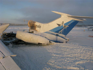
Kolavia Flight 348
2011 aviation incident
Distance: Approx. 3755 meters
Latitude and longitude: 61.34166667,73.40277778
On 1 January 2011, Kolavia Flight 348, a Tupolev Tu-154 on a domestic scheduled passenger flight from Surgut to Moscow, Russia, caught fire while taxiing out for take-off. Passengers were evacuated, but three were killed and 43 injured. A subsequent investigation concluded that the fire had started in an electric panel for which maintenance was never prescribed.

22 January 1971 Surgut Aeroflot Antonov An-12 crash
Aviation accident in the Soviet Union
Distance: Approx. 3807 meters
Latitude and longitude: 61.34333333,73.40333333
The 22 January 1971 Surgut Aeroflot Antonov An-12 crash occurred when an Aeroflot Antonov An-12B, registered CCCP-11000, flying from Omsk Tsentralny Airport, in the Soviet Union's (RSFSR) on 22 January 1971, crashed 15 km (9.3 mi) short of the runway on approach to Surgut International Airport, Surgut, RSFSR. An investigation found the aircraft's ice protection system was ineffective because the engine bleed air valves were closed during the flight; ice therefore built up on the aircraft causing it to go out of control.
Bely Yar, Khanty-Mansi Autonomous Okrug
Urban-type settlement in Khanty-Mansi Autonomous Okrug, Russia
Distance: Approx. 9070 meters
Latitude and longitude: 61.265,73.2587
Bely Yar (Russian: Белый Яр) is an urban locality (an urban-type settlement) in Surgutsky District of Khanty-Mansi Autonomous Okrug, Russia. Population: 14,580 (2010 Census); 14,392 (2002 Census); 13,004 (1989 Soviet census).
Weather in this IP's area
light snow
1 Celsius
-3 Celsius
1 Celsius
1 Celsius
1011 hPa
100 %
1011 hPa
1004 hPa
10000 meters
4 m/s
250 degree
100 %
07:02:28
16:40:05