85.92.179.214 - IP Lookup: Free IP Address Lookup, Postal Code Lookup, IP Location Lookup, IP ASN, Public IP
Country:
 Great Britain
Region:
City:
Location:
Time Zone:
Postal Code:
ISP:
ASN:
language:
User-Agent:
Proxy IP:
Blacklist:
IP information under different IP Channel
ip-api
Country
Region
City
ASN
Time Zone
ISP
Blacklist
Proxy
Latitude
Longitude
Postal
Route
db-ip
Country
Region
City
ASN
Time Zone
ISP
Blacklist
Proxy
Latitude
Longitude
Postal
Route
IPinfo
Country
Region
City
ASN
Time Zone
ISP
Blacklist
Proxy
Latitude
Longitude
Postal
Route
IP2Location
85.92.179.214Country
gbRegion
england
City
gorleston-on-sea
Time Zone
Europe/London
ISP
Language
User-Agent
Latitude
Longitude
Postal
ipdata
Country
Region
City
ASN
Time Zone
ISP
Blacklist
Proxy
Latitude
Longitude
Postal
Route
Popular places and events near this IP address

River Yare
River in England
Distance: Approx. 463 meters
Latitude and longitude: 52.5725,1.7375
The River Yare is a river in the English county of Norfolk. In its lower reaches it is one of the principal navigable waterways of The Broads and connects with the rest of the network. The river rises south of Dereham to the west to the village of Shipdham.

Gorleston-on-Sea
Town in Norfolk, England
Distance: Approx. 572 meters
Latitude and longitude: 52.5757,1.7235
Gorleston-on-Sea (), historically and colloquially known as Gorleston, is a seaside town in the borough of Great Yarmouth in Norfolk, England. It lies to the south of Great Yarmouth, on the opposite side of the mouth of the River Yare. Historically in Suffolk, it was a port town at the time of the Domesday Book.

James Paget University Hospital
Hospital in Norfolk , England
Distance: Approx. 1535 meters
Latitude and longitude: 52.5617,1.7177
James Paget University Hospital is at Gorleston-on-Sea, Great Yarmouth, Norfolk, England, on the A47 Lowestoft Road. It is managed by the James Paget University Hospitals NHS Foundation Trust.

Great Yarmouth Outer Harbour
English port
Distance: Approx. 671 meters
Latitude and longitude: 52.5759,1.7394
Great Yarmouth Outer Harbour is a port constructed on the east coast of England at Great Yarmouth. Construction work on the Outer Harbour began in June 2007. The harbour which is built in the South Denes area was planned to bring trade to the area.

East Norfolk Sixth Form College
Sixth form college in Great Yarmouth, Norfolk, East Anglia, England
Distance: Approx. 885 meters
Latitude and longitude: 52.5782,1.7208
East Norfolk Sixth Form College (commonly abbreviated to EN) is a sixth form college in the Gorleston-on-Sea area of Great Yarmouth, Norfolk, England. The college ranges from about 1,600 students most of whom are between the ages of 16–18. These students enroll from areas across Norfolk and North Suffolk.

Gorleston (Range Rear) Lighthouse
Lighthouse
Distance: Approx. 145 meters
Latitude and longitude: 52.572142,1.732305
Gorleston (Range Rear) Lighthouse is located near mouth of River Yare in the Gorleston-on-Sea area of Great Yarmouth in the English county of Norfolk. The lighthouse was built in 1878. Gorleston-on-Sea lighthouse carries two lights.

Gorleston-on-Sea railway station
Former railway station in Norfolk, England
Distance: Approx. 512 meters
Latitude and longitude: 52.5699,1.7251
Gorleston-on-Sea railway station served the town of Gorleston-on-Sea in Norfolk, England. It was a stop on the Norfolk and Suffolk Joint Railway's Yarmouth-Lowestoft line that closed in 1970.
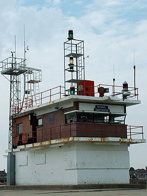
Gorleston South Pier Lighthouse
Lighthouse
Distance: Approx. 506 meters
Latitude and longitude: 52.572128,1.738036
Gorleston South Pier Lighthouse and Coastwatch watch station is located in the town of Gorleston in the English county of Norfolk. The lighthouse and station is located at the end of the south pier of seaport on the south side of Great Yarmouth.

Great Yarmouth Power Station
Gas power station in Norfolk, England
Distance: Approx. 1224 meters
Latitude and longitude: 52.583884,1.733255
Great Yarmouth Power Station is combined cycle gas turbine power station on South Denes Road in Great Yarmouth in Norfolk, England, with a maximum output of 420 MW electricity, opened in 2001. It is built on the site of an oil-fired power station, built in 1958 and closed and demolished in the 1990s. A coal-fired power station was built in Great Yarmouth in 1894 and operated until 1961.

Raid on Yarmouth
Raid carried out by the Imperial German Navy
Distance: Approx. 1348 meters
Latitude and longitude: 52.57,1.75
The Raid on Yarmouth, on 3 November 1914, was an attack by the Imperial German Navy on the British North Sea port and town of Great Yarmouth. German shells only landed on the beach causing little damage to the town, after German ships laying mines offshore were interrupted by British destroyers. The British submarine HMS D5 was sunk by a German mine as it was leaving harbour to attack the German ships.

Great Yarmouth and Gorleston Lifeboat Station
RNLI Lifeboat Station in Great Yarmouth and Gorleston lifeboat station, England
Distance: Approx. 284 meters
Latitude and longitude: 52.57541944,1.73203889
Great Yarmouth and Gorleston lifeboat station (not to be confused with Yarmouth on the Isle of Wight) is a RNLI base in Norfolk, England. There were originally two separate stations at Great Yarmouth and Gorleston – two coastal towns either side of the River Yare. These were merged in 1926.
Cliff Park Ormiston Academy
Academy in Gorleston-on-Sea Great Yarmouth, Norfolk, England
Distance: Approx. 1396 meters
Latitude and longitude: 52.5612,1.7237
Cliff Park Ormiston Academy (formerly Cliff Park High School) is a coeducational secondary school with academy status, located in the Gorleston-on-Sea area of Great Yarmouth in the English county of Norfolk. The school educates children aged 11 to 16.
Weather in this IP's area
broken clouds
4 Celsius
0 Celsius
4 Celsius
5 Celsius
1019 hPa
87 %
1019 hPa
1018 hPa
10000 meters
5.58 m/s
7.44 m/s
13 degree
84 %