Country:
 Belgium
Region:
City:
Latitude and Longitude:
Time Zone:
Postal Code:
IP information under different IP Channel
ip-api
Country
Region
City
ASN
Time Zone
ISP
Blacklist
Proxy
Latitude
Longitude
Postal
Route
IPinfo
Country
Region
City
ASN
Time Zone
ISP
Blacklist
Proxy
Latitude
Longitude
Postal
Route
MaxMind
Country
Region
City
ASN
Time Zone
ISP
Blacklist
Proxy
Latitude
Longitude
Postal
Route
Luminati
Country
BERegion
bru
City
brussels
ASN
Time Zone
Europe/Brussels
ISP
SmalS vzw
Latitude
Longitude
Postal
db-ip
Country
Region
City
ASN
Time Zone
ISP
Blacklist
Proxy
Latitude
Longitude
Postal
Route
ipdata
Country
Region
City
ASN
Time Zone
ISP
Blacklist
Proxy
Latitude
Longitude
Postal
Route
Popular places and events near this IP address
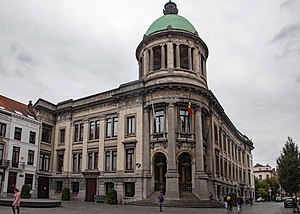
Molenbeek-Saint-Jean
Municipality of the Brussels-Capital Region, Belgium
Distance: Approx. 766 meters
Latitude and longitude: 50.85777778,4.31583333
Molenbeek-Saint-Jean (French, pronounced [molœnbek sɛ̃ ʒɑ̃, -bɛk -] ) or Sint-Jans-Molenbeek (Dutch, pronounced [sɪɲˈtɕɑns ˈmoːlə(m)ˌbeːk] ), often simply called Molenbeek, is one of the 19 municipalities of the Brussels-Capital Region, Belgium. Located in the western part of the region, it is bordered by the City of Brussels, from which it is separated by the Brussels–Charleroi Canal, as well as by the municipalities of Anderlecht, Berchem-Sainte-Agathe, Dilbeek, Jette, and Koekelberg. The Molenbeek brook, from which it takes its name, flows through the municipality.
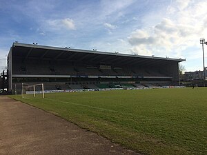
Edmond Machtens Stadium
Football stadium in Brussels, Belgium
Distance: Approx. 458 meters
Latitude and longitude: 50.855,4.31111111
The Edmond Machtens Stadium (French: Stade Edmond Machtens; Dutch: Edmond Machtensstadion) is a football stadium located in the municipality of Molenbeek-Saint-Jean in Brussels, Belgium. It was the home ground of Belgian Second Division club FC Molenbeek Brussels Strombeek, from the 2003 merger between R White Daring Molenbeek and KFC Strombeek until its dissolution in 2014. Prior to this, it was home to R White Daring Molenbeek and of R Daring Club de Bruxelles.

Jacques Brel metro station
Metro station in Brussels, Belgium
Distance: Approx. 778 meters
Latitude and longitude: 50.845,4.31861111
Jacques Brel is a Brussels Metro station on the western branch of line 5. It is located in the municipality of Anderlecht, in the western part of Brussels, Belgium. The station is named after the Belgian singer, songwriter, and poet Jacques Brel.

Osseghem metro station
Metro station in Brussels, Belgium
Distance: Approx. 1054 meters
Latitude and longitude: 50.85694444,4.325
Osseghem (French, former Dutch spelling) or Ossegem (modern Dutch) is a Brussels Metro station on lines 2 and 6. It is located under the Chaussée de Gand/Gentse Steenweg in the municipality of Molenbeek-Saint-Jean, in the western part of Brussels, Belgium. The station takes its name from the nearby Osseghem/Ossegem neighbourhood.

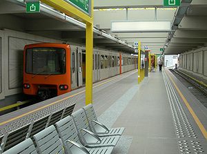
Beekkant metro station
Metro station in Brussels, Belgium
Distance: Approx. 729 meters
Latitude and longitude: 50.85361111,4.32277778
Beekkant is a Brussels Metro station on lines 1, 2, 5 and 6. It is located under the Boulevard Edmond Machtens/Edmond Machtenslaan in the municipality of Molenbeek-Saint-Jean, in the western part of Brussels, Belgium. The station's name translates into English as "Brookside".
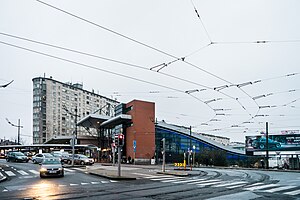
Brussels-West station
Metro station in Brussels, Belgium
Distance: Approx. 590 meters
Latitude and longitude: 50.84888889,4.32083333
Brussels-West Station (French: Gare de l'Ouest; Dutch: Weststation) is a multimodal transport hub located in the municipality of Molenbeek-Saint-Jean, in the western part of Brussels, Belgium. It mainly consists of Gare de l'Ouest (French) or Weststation (Dutch), a Brussels Metro station on lines 1, 2, 5 and 6, as well as a tram and bus stop. Additionally, Brussels-West railway station (French: Gare de Bruxelles-Ouest; Dutch: Station Brussel-West) is a railway station operated by the National Railway Company of Belgium (SNCB/NMBS).

Aumale metro station
Metro station in Brussels, Belgium
Distance: Approx. 1298 meters
Latitude and longitude: 50.83944444,4.3125
Aumale is a Brussels Metro station on the western branch of line 5. It is located in the municipality of Anderlecht, in the western part of Brussels, Belgium. The station received its name from the aboveground street Rue d'Aumale/Aumalestraat.
Delacroix metro station
Metro station in Brussels, Belgium
Distance: Approx. 1042 meters
Latitude and longitude: 50.845,4.32444444
Delacroix is a Brussels Metro station on lines 2 and 6. It is located in the municipality of Anderlecht, in the western part of Brussels, Belgium. It is an elevated station, running parallel to the Rue Léon Delacroix/Léon Delacroixstraat, and forming a bridge-viaduct over the Brussels–Charleroi Canal, with entries and exits leading to and from both banks of the canal.
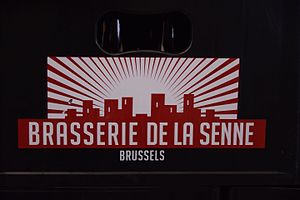
Brasserie de la Senne
Belgian brewery
Distance: Approx. 1068 meters
Latitude and longitude: 50.8602,4.3084
Brasserie de la Senne is a brewery in Brussels, Belgium, named for the river Senne which flows through the city.

Molenbeek-Saint-Jean Cemetery
Cemetery in Molenbeek, Belgium
Distance: Approx. 1127 meters
Latitude and longitude: 50.86111111,4.31083333
Molenbeek-Saint-Jean Cemetery (French: Cimetière de Molenbeek-Saint-Jean; Dutch: Begraafplaats van Sint-Jans-Molenbeek) is a cemetery belonging to Molenbeek-Saint-Jean in Brussels, Belgium, where the municipality's inhabitants have the right to be buried. It is located at 539, Chaussée de Gand/Gentsesteenweg, in the west of the municipality. The ensemble extends over 1.5 hectares (3.7 acres).

Scheut
Neighbourhood in Brussels, Belgium
Distance: Approx. 567 meters
Latitude and longitude: 50.8475,4.3075
Scheut (French: [skøt]; Dutch: [sxøːt] ) is a district of Anderlecht, a municipality of Brussels, Belgium. Located in the north of Anderlecht, it is bounded by the border with the municipality of Molenbeek-Saint-Jean to the north, the historical centre of Anderlecht to the south, the Birmingham district to the east, the Scheutveld district to the west and the semi-natural site of the Scheutbos to the north-west. The district is crossed by the Chaussée de Ninove/Ninoofsesteenweg running east–west and is served by the metro stations Aumale, Jacques Brel, and Gare de l'Ouest/Weststation (Brussels-West Station).

Karreveld Castle
Castle-farm in Brussels, Belgium
Distance: Approx. 1032 meters
Latitude and longitude: 50.86027778,4.31527778
Karreveld Castle (French: Château du Karreveld; Dutch: Kasteel Karreveld) is a castle-farm in Molenbeek-Saint-Jean, a municipality of Brussels, Belgium. The castle and surrounding park are used for cultural events and meetings of the municipal council. This site is served by Osseghem/Ossegem metro station on lines 2 and 6 of the Brussels Metro.
Weather in this IP's area
overcast clouds
15 Celsius
15 Celsius
15 Celsius
15 Celsius
1001 hPa
87 %
1001 hPa
996 hPa
10000 meters
6.84 m/s
13.63 m/s
222 degree
100 %
07:53:00
19:07:42