85.9.142.186 - IP Lookup: Free IP Address Lookup, Postal Code Lookup, IP Location Lookup, IP ASN, Public IP
Country:
 Tajikistan
Region:
City:
Location:
Time Zone:
Postal Code:
ISP:
ASN:
language:
User-Agent:
Proxy IP:
Blacklist:
IP information under different IP Channel
ip-api
Country
Region
City
ASN
Time Zone
ISP
Blacklist
Proxy
Latitude
Longitude
Postal
Route
db-ip
Country
Region
City
ASN
Time Zone
ISP
Blacklist
Proxy
Latitude
Longitude
Postal
Route
IPinfo
Country
Region
City
ASN
Time Zone
ISP
Blacklist
Proxy
Latitude
Longitude
Postal
Route
IP2Location
85.9.142.186Country
tjRegion
nohiyahoi tobei jumhuri
City
boshkengash
Time Zone
ISP
Language
User-Agent
Latitude
Longitude
Postal
ipdata
Country
Region
City
ASN
Time Zone
ISP
Blacklist
Proxy
Latitude
Longitude
Postal
Route
Popular places and events near this IP address
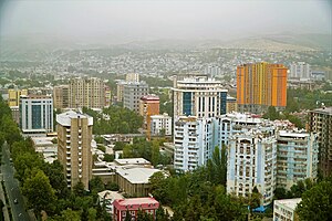
Dushanbe
Capital and largest city of Tajikistan
Distance: Approx. 8159 meters
Latitude and longitude: 38.53666667,68.78
Dushanbe is the capital and largest city of Tajikistan. As of March 2024, Dushanbe had a population of 1,564,700, with this population being largely Tajik. Until 1929, the city was known in Russian as Dyushambe, and from 1929 to 1961 as Stalinabad, after Joseph Stalin.

Tajik Soviet Socialist Republic
1929–1991 republic of the Soviet Union
Distance: Approx. 8206 meters
Latitude and longitude: 38.53333333,68.76666667
The Tajik Soviet Socialist Republic, also commonly known as Soviet Tajikistan, the Tajik SSR, TaSSR, or simply Tajikistan, was one of the constituent republics of the Soviet Union which existed from 1929 to 1991 in Central Asia. The Tajik Republic was created on 5 December 1929 as a national entity for the Tajik people within the Soviet Union. It succeeded the Tajik Autonomous Soviet Socialist Republic (Tajik SSR), which had been created on 14 October 1924 as a part of the predominantly Turkic Uzbek SSR in the process of national delimitation in Soviet Central Asia.

Hisar Valley
Place in Khatlon Region, Tajikistan
Distance: Approx. 8206 meters
Latitude and longitude: 38.53333333,68.76666667
Hisar (also Gissar, Gisar, Hissar, or Hisor) Valley in Tajikistan runs east–west along the southern slopes of Hisar Range and on the northern border of Khatlon Province. It is about 100 km long and up to 20 km wide in the middle, stretching from Vahdat district in the east to Tursunzoda district on the border with Uzbekistan in the west, with the capital Dushanbe and Hisar district at its center. The elevations in the valley range from 700 meters (2,300 ft) to 1,000 meters (3,300 ft).
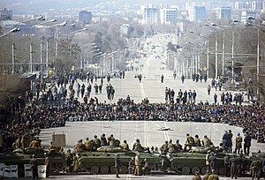
1990 Dushanbe riots
Violent unrest in the Tajik SSR of the Soviet Union
Distance: Approx. 8159 meters
Latitude and longitude: 38.53666667,68.78
The 1990 Dushanbe riots marked a period of heightened civil disobedience and inter-ethnic violence in the capital city of the Tajik SSR of the Soviet Union. Existing tensions over lacking economic and political reforms were exacerbated by the arrival of Armenian refugees from the Azerbaijan SSR due to the Nagorno-Karabakh conflict. The mass movement of Tajik nationalists (e.g., the Rastokhez), anti-communists, and Islamists targeted ethnic minorities, such as Armenians, Russians, Jews, as well as unaffiliated Tajiks—namely women who did not conform to Islamic clothing standards.
Somoniyon
Place in Districts of Republican Subordination, Tajikistan
Distance: Approx. 3630 meters
Latitude and longitude: 38.44222222,68.77694444
Somoniyon (Tajik: Сомониён, Russian: сомониане) is a town in Tajikistan. It is the administrative capital of Rudaki District, one of the Districts of Republican Subordination, lying 17 km south of the national capital of Dushanbe and just east of the river Kofarnihon. The population of the town is 25,200 (January 2020 estimate).

Varzob (river)
River in Tajikistan
Distance: Approx. 3159 meters
Latitude and longitude: 38.4818,68.7751
The Varzob (Tajik: Варзоб, Russian: Варзоб, in the lower reaches also Dushanbinka) is a right tributary of the river Kofarnihon in Tajikistan. It is 71 kilometres (44 mi) long and has a basin area of 1,740 square kilometres (670 sq mi). The Varzob rises on the southern flank of the Gissar Mountains, and flows south.
Chimteppa
Village and Jamoat in Districts of Republican Subordination, Tajikistan
Distance: Approx. 6273 meters
Latitude and longitude: 38.46666667,68.73333333
Chimteppa (Tajik: Чимтеппа, formerly: Oqkurgan) is a village and jamoat in Tajikistan. It is located in Rudaki District, one of the Districts of Republican Subordination. The jamoat has a total population of 45,221 (2015).
Chorgulteppa
Jamoat in Districts of Republican Subordination, Tajikistan
Distance: Approx. 7257 meters
Latitude and longitude: 38.43333333,68.73333333
Chorgulteppa (Tajik: Чоргултеппа, formerly: Kuktosh) is a jamoat in Tajikistan. It is located in Rudaki District, one of the Districts of Republican Subordination. The jamoat has a total population of 37,551 (2015).
Rossiya, Tajikistan
Jamoat in Districts of Republican Subordination, Tajikistan
Distance: Approx. 7550 meters
Latitude and longitude: 38.53333333,68.81666667
Rossiya (Russian and Tajik: Россия, also Kolkhozi Rossiya; formerly: Qushteppa) is a jamoat in Tajikistan. It is located in Rudaki District, one of the Districts of Republican Subordination. The jamoat has a total population of 31,030 (2015).
Zainabobod
Jamoat in Districts of Republican Subordination, Tajikistan
Distance: Approx. 5298 meters
Latitude and longitude: 38.50833333,68.83333333
Zainabobod (Russian: Зайнабобад; Tajik: Зайнабобод) is a jamoat in Tajikistan. It is located in Rudaki District, one of the Districts of Republican Subordination. The jamoat has a total population of 36,844 (2015).
Technological University of Tajikistan
Distance: Approx. 8224 meters
Latitude and longitude: 38.5303,68.7586
Technological University of Tajikistan (Tajik: Донишгоҳи технологии Тоҷикистон; Russian: технологический университет Таджикистана, ТУТ) is a private educational institution in Dushanbe, focused on training specialists in the light and food industries. It was established on September 20, 1990, as the Tajik Higher College of Technology by a resolution of the Council of Ministers of the Republic. Its Textile Industry Program trains students as technicians, managers, designers, and artists in the production of textiles and apparel.
Mirzo Tursunzoda, Rudaki District
Town and Jamoat in Districts of Republican Subordination, Tajikistan
Distance: Approx. 3038 meters
Latitude and longitude: 38.48888889,68.78611111
Mirzo Tursunzoda (Tajik: Мирзо Турсунзода) is a town and jamoat in Tajikistan. It is located in Rudaki District, one of the Districts of Republican Subordination. The population of the town is 20,500 (January 2020 estimate).
Weather in this IP's area
broken clouds
7 Celsius
5 Celsius
7 Celsius
7 Celsius
1024 hPa
45 %
1024 hPa
916 hPa
6000 meters
3 m/s
60 degree
54 %