85.9.129.197 - IP Lookup: Free IP Address Lookup, Postal Code Lookup, IP Location Lookup, IP ASN, Public IP
Country:
 Tajikistan
Region:
City:
Location:
Time Zone:
Postal Code:
ISP:
ASN:
language:
User-Agent:
Proxy IP:
Blacklist:
IP information under different IP Channel
ip-api
Country
Region
City
ASN
Time Zone
ISP
Blacklist
Proxy
Latitude
Longitude
Postal
Route
db-ip
Country
Region
City
ASN
Time Zone
ISP
Blacklist
Proxy
Latitude
Longitude
Postal
Route
IPinfo
Country
Region
City
ASN
Time Zone
ISP
Blacklist
Proxy
Latitude
Longitude
Postal
Route
IP2Location
85.9.129.197Country
tjRegion
kuhistoni badakhshon
City
khorugh
Time Zone
Asia/Dushanbe
ISP
Language
User-Agent
Latitude
Longitude
Postal
ipdata
Country
Region
City
ASN
Time Zone
ISP
Blacklist
Proxy
Latitude
Longitude
Postal
Route
Popular places and events near this IP address
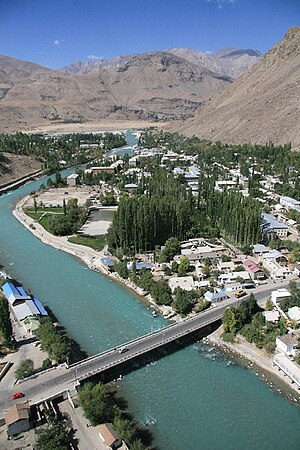
Khorog
Capital of Gorno-Badakhshan, Tajikistan
Distance: Approx. 757 meters
Latitude and longitude: 37.48333333,71.55
Khorog (Russian: Хорог [xɐˈrok]), also Khorugh (Tajik: Хоруғ [χɔˈɾuʁ]) or Kharagh (Shughni: Харағ [χɐˈɾaʁ]), is the capital of Gorno-Badakhshan, Tajikistan. It is also the capital of the Shughnon District of Gorno-Badakhshan. It has a population of 30,500 (2020 est.).

Gunt
River in Tajikistan
Distance: Approx. 2950 meters
Latitude and longitude: 37.4898,71.5196
The Gunt (Russian: Гунт, Tajik: Ғунд Ghund or Аличур Alichur, historically in English also Ghund) is a river in the south of Tajikistan, north of the Shughnon Range. It is 296 kilometres (184 mi) long and has a basin area of 13,700 square kilometres (5,300 sq mi). Its source, Lake Yashilkul, is situated at the edge of the Alichur Pamir, a high plateau or pamir at an elevation of 3,720 m.

Aga Khan Lycée, Khorog
Private school
Distance: Approx. 3274 meters
Latitude and longitude: 37.488,71.59
The Aga Khan Lycée, Khorog is a school that was established in September 1998. Emomali Rahmonov, the President of the Republic of Tajikistan, inaugurated the school with the Aga Khan. The Lycée, part of the Aga Khan Education Services (AKES), is built on the premises of the former School #3 (named after Kirov), a school with a distinguished history in Gorno Badakhshan Autonomous Oblast (GBAO).
Sheghnan Airport
Airport in Afghanistan
Distance: Approx. 9762 meters
Latitude and longitude: 37.56666667,71.5
Sheghnan Airport (IATA: SGA, ICAO: OASN) is located in the extreme northeast section of Afghanistan deep within Pamir mountain ranges in the Badakhshan Province of Afghanistan. The airport is close to the border with Tajikistan; to the east and parallel of the Shighnan airport is Khorog Airport in Tajikistan. These two airports are only 2,000 feet (0.6 km) apart and are separated by a river.
Khorugh State University
Distance: Approx. 245 meters
Latitude and longitude: 37.4919,71.5529
Khorugh State University (also known as Khorog State University), is a public university located in Khorugh, GBAO, Tajikistan. It is located in the center of Khorugh (the capital of GBAO), the only urban center in the region. The University has an enrollment of approximately 4,000 students, both full-time (daytime) and students studying by correspondence.
Ghar Javin
Place in Badakhshan, Afghanistan
Distance: Approx. 9454 meters
Latitude and longitude: 37.46666667,71.45
Ghar Javin is the name of a mountain pass and of a nearby village in Badakhshan Province in north-eastern Afghanistan. The valley contains three villages of the same time. Nearby is the direct road from Bar Panja, located some miles downstream, and Badakhshan.
Shiveh
Place in Badakhshan Province, Afghanistan
Distance: Approx. 4819 meters
Latitude and longitude: 37.5,71.5
Shiveh is a village in Badakhshan Province in north-eastern Afghanistan.

Tajik–Afghan bridge at Tem-Demogan
Bridge in Shughnan, Tajikistan
Distance: Approx. 5538 meters
Latitude and longitude: 37.52416667,71.50777778
The Tajik–Afghan bridge at Tem-Demogan was opened on 3 November 2002. It spans the Panj River. It was the first of four bridges planned to be built with the assistance of the Aga Khan Foundation.

1993 Tajikistan Airlines Yakovlev Yak-40 crash
1993 aviation accident in Tajikistan
Distance: Approx. 4715 meters
Latitude and longitude: 37.5125,71.508
On 28 August 1993 a non-scheduled domestic passenger flight operated by Tajikistan Airlines and served by a Yakovlev Yak-40 crashed during takeoff at Khorog Airport, killing 82 people on board (including 14 children). Militants during the civil war in Tajikistan forced the crew to take more passengers than the aircraft was able to carry, which led to an excess takeoff weight. Unable to take off, the aircraft overran the runway at high speed, struck several obstacles and fell into the Panj River.

Shakhdara River
River in Tajikistan
Distance: Approx. 3501 meters
Latitude and longitude: 37.482778,71.591667
The Shakhdara (Tajik: Шоҳдара, Russian: Шахдара) is a left tributary of the Gunt River in southeastern Tajikistan. The Shakhdara has its source in the eastern part of the Shakhdara Range, not far from the Matz Pass and the Afghan border, in the extreme south of the Pamir Mountains . From there it flows in a westerly direction.
Weather in this IP's area
overcast clouds
-14 Celsius
-14 Celsius
-14 Celsius
-14 Celsius
1041 hPa
79 %
1041 hPa
683 hPa
10000 meters
0.83 m/s
1.03 m/s
314 degree
100 %