85.89.2.161 - IP Lookup: Free IP Address Lookup, Postal Code Lookup, IP Location Lookup, IP ASN, Public IP
Country:
Region:
City:
Location:
Time Zone:
Postal Code:
IP information under different IP Channel
ip-api
Country
Region
City
ASN
Time Zone
ISP
Blacklist
Proxy
Latitude
Longitude
Postal
Route
Luminati
Country
Region
50
City
levanger
ASN
Time Zone
Europe/Oslo
ISP
Nte Telekom As
Latitude
Longitude
Postal
IPinfo
Country
Region
City
ASN
Time Zone
ISP
Blacklist
Proxy
Latitude
Longitude
Postal
Route
IP2Location
85.89.2.161Country
Region
trondelag
City
levanger
Time Zone
Europe/Oslo
ISP
Language
User-Agent
Latitude
Longitude
Postal
db-ip
Country
Region
City
ASN
Time Zone
ISP
Blacklist
Proxy
Latitude
Longitude
Postal
Route
ipdata
Country
Region
City
ASN
Time Zone
ISP
Blacklist
Proxy
Latitude
Longitude
Postal
Route
Popular places and events near this IP address
Momarka
Village in Levanger Municipality, Norway
Distance: Approx. 2228 meters
Latitude and longitude: 63.7276,11.2841
Momarka is a village in Levanger Municipality in Trøndelag county, Norway. It is located just south of the town of Levanger. The Nordlandsbanen railway line and the European route E6 highway both run through the village.

Levanger Station
Railway station in Levanger, Norway
Distance: Approx. 194 meters
Latitude and longitude: 63.744731,11.300719
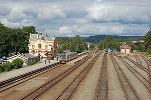
Levanger Station (Norwegian: Levanger stasjon) is a railway station located in the centre of the town of Levanger in Levanger Municipality in Trøndelag county, Norway. The station is located along the Nordland Line. The station serves both local and express trains northbound through Innherred and to Nordland, and southbound to Trondheim.

HiNT station
Railway station in Levanger, Norway
Distance: Approx. 1165 meters
Latitude and longitude: 63.752572,11.318707
HiNT station, formally known as Røstad station (Norwegian: Røstad stasjon), is a railway station located in the town of Levanger in Levanger Municipality in Trøndelag county, Norway. It is located on the Nordland Line. The station gets its name from being located just beside the Nord-Trøndelag University College (Norwegian: Høgskolen i Nord-Trøndelag) campus at Røstad as well as the Norwegian Food Safety Authority.

Sykehuset Levanger Station
Former railway station in Levanger, Norway
Distance: Approx. 712 meters
Latitude and longitude: 63.74083333,11.2925
Sykehuset Levanger Station (Norwegian: Sykehuset Levanger holdeplass), previously Innherred Sykehus Station (Innherred sykehus holdeplass), was a railway station located in the town of Levanger in Levanger Municipality in Trøndelag county, Norway. It was located on the Nordland Line. The station was located adjacent to Levanger Hospital (Sykehuset Levanger).

Levanger Hospital
Hospital in Trøndelag county, Norway
Distance: Approx. 1200 meters
Latitude and longitude: 63.74,11.28
Levanger Hospital (Norwegian: Sykehuset Levanger) is a hospital located in the town of Levanger in Levanger Municipality in Trøndelag county, Norway. The hospital is located along the road Kirkegata on the west side of the town of Levanger. Along with Namsos Hospital, this is one of two hospitals in the old Nord-Trøndelag county (now part of Trøndelag county).
Inntrøndelag
Distance: Approx. 0 meters
Latitude and longitude: 63.7464,11.2996
Inntrøndelag or Inn-Trøndelag is a traditional district that encompasses the central part of Trøndelag county in Norway. It usually includes the area surrounding the inner part of the Trondheimsfjord. It is often used interchangeably with the name Innherred, but Inntrøndelag also includes the Stjørdalen valley.

Norwegian County Road 774
County road in Trøndelag, Norway
Distance: Approx. 603 meters
Latitude and longitude: 63.74998,11.30878
Norwegian County Road 774 (Norwegian: Fylkesvei 774) is a 4.2-kilometre (2.6 mi) long county road in Levanger Municipality in Trøndelag county, Norway. It begins at the junction with the European route E06 highway at the village of Mule. It then heads into and through parts of the town of Levanger.
Stjør- and Verdal District Court
District court in Norway
Distance: Approx. 90 meters
Latitude and longitude: 63.746,11.298
Stjør- and Verdal District Court (Norwegian: Stjør- og Verdal tingrett) was a district court in Nord-Trøndelag county, Norway. The court was based in the town of Levanger. The court existed from 1635 until 2011.
Bamberg Church
Church in Trøndelag, Norway
Distance: Approx. 1122 meters
Latitude and longitude: 63.75034099,11.27863687
Bamberg Church (Norwegian: Bamberg kirke) is a parish church of the Church of Norway in Levanger Municipality in Trøndelag county, Norway. It is located in the Neset area of the town of Levanger. It is an annex church for the Levanger parish which is part of the Stiklestad prosti (deanery) in the Diocese of Nidaros.

Levanger Church
Church in Trøndelag, Norway
Distance: Approx. 239 meters
Latitude and longitude: 63.74518986,11.29558414
Levanger Church (Norwegian: Levanger kirke) is a parish church of the Church of Norway in Levanger Municipality in Trøndelag county, Norway. The church is located in the town of Levanger, along the road Kirkegata. It is the main church for the Levanger parish which is part of the Stiklestad prosti (deanery) in the Diocese of Nidaros.
Levangselva
River in Trøndelag, Norway
Distance: Approx. 714 meters
Latitude and longitude: 63.752818,11.299438
Levangselva is a river that flows through Levanger Municipality in Trøndelag county, Norway. It flows into the Trondheimsfjord in the town of Levanger. The area through which the river flows was once part of the old Frol Municipality.

Levanger (town)
Town in Trøndelag, Norway
Distance: Approx. 46 meters
Latitude and longitude: 63.7465,11.2987
(Norwegian) or Levangke (Southern Sami) is a town and the administrative center of Levanger Municipality in Trøndelag county, Norway. The university town is located along the eastern shore of the Trondheimsfjorden, at the mouth of the river Levangselva. The town is located about half-way between the towns of Steinkjer and Stjørdalshalsen.
Weather in this IP's area
few clouds
-14 Celsius
-19 Celsius
-14 Celsius
-14 Celsius
1000 hPa
87 %
1000 hPa
1000 hPa
10000 meters
2.05 m/s
2.44 m/s
80 degree
18 %