85.87.24.187 - IP Lookup: Free IP Address Lookup, Postal Code Lookup, IP Location Lookup, IP ASN, Public IP
Country:
Region:
City:
Location:
Time Zone:
Postal Code:
IP information under different IP Channel
ip-api
Country
Region
City
ASN
Time Zone
ISP
Blacklist
Proxy
Latitude
Longitude
Postal
Route
Luminati
Country
Region
pv
City
andoain
ASN
Time Zone
Europe/Madrid
ISP
Euskaltel S.A.
Latitude
Longitude
Postal
IPinfo
Country
Region
City
ASN
Time Zone
ISP
Blacklist
Proxy
Latitude
Longitude
Postal
Route
IP2Location
85.87.24.187Country
Region
pais vasco
City
san sebastian
Time Zone
Europe/Madrid
ISP
Language
User-Agent
Latitude
Longitude
Postal
db-ip
Country
Region
City
ASN
Time Zone
ISP
Blacklist
Proxy
Latitude
Longitude
Postal
Route
ipdata
Country
Region
City
ASN
Time Zone
ISP
Blacklist
Proxy
Latitude
Longitude
Postal
Route
Popular places and events near this IP address

Atotxa Stadium
Football stadium in San Sebastián, Spain
Distance: Approx. 746 meters
Latitude and longitude: 43.3195,-1.975
Atotxa (Spanish: Atocha) was a football stadium in San Sebastián, Spain. It was the home ground of Real Sociedad until 1993 when it was replaced by Anoeta Stadium. It had superseded Ondarreta Stadium 80 years earlier.

Roman Catholic Diocese of San Sebastián
Roman Catholic diocese in Spain
Distance: Approx. 682 meters
Latitude and longitude: 43.3167,-1.9815
The Diocese of San Sebastián (Latin: Sancti Sebastiani) is a Latin Church diocese of the Catholic Church located in the city of San Sebastián in the ecclesiastical province of Pamplona y Tudela in Spain.

Tabakalera
International Centre for Contemporary Culture in Basque Country, Spain
Distance: Approx. 435 meters
Latitude and longitude: 43.3167,-1.9754
Tabakalera is a former tobacco factory in San Sebastián, Basque Autonomous Community, Spain, which was converted into a contemporary culture centre. Located in the Egia district of San Sebastián, next to the Estación del Norte railway station and the Cristina Enea Park, it takes up one of the biggest plots (13.277 m2) of the urban area. For 90 years (1913–2003) Tabakalera was a tobacco factory.

Beach of La Concha
Beach in Donostia-San Sebastian, Basque Country
Distance: Approx. 1080 meters
Latitude and longitude: 43.3175,-1.98666667
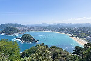
The Beach of La Concha (Basque: Kontxa Hondartza [kontʃa ondarts̻a]; Spanish: Playa de La Concha [ˈplaʝa ðe la ˈkontʃa], "cone shell beach") is a crescent shaped urban seaboard of the city of San Sebastián located at the Bay of La Concha in the Basque Country, in northern Spain. Its name “Concha” is given upon its remarkably regular shape. The scenic setting in the Bay of La Concha and the 19th century elegance of fashionable seaside resorts have made the site very popular, as it is frequently cited as one of the most beautiful and the most famous urban beaches in Europe.

San Sebastián Cathedral
Distance: Approx. 680 meters
Latitude and longitude: 43.31666667,-1.9815
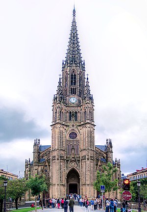
The Cathedral of the Good Shepherd (Basque: Artzain Onaren katedrala, Spanish: Catedral del Buen Pastor de San Sebastián) located in the city of San Sebastián, Gipuzkoa, Basque Country, Spain. It is the seat of the suffragan Diocese of San Sebastián and subordinated to the Archdiocese of Pamplona y Tudela. The most remarkable religious building of San Sebastián, it is endowed with a strong verticality and is the largest in Gipuzkoa.

María Cristina Bridge
Distance: Approx. 568 meters
Latitude and longitude: 43.3173,-1.9783
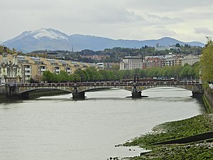
María Cristina Bridge (Basque: Maria Kristina zubia, Spanish: Puente de María Cristina) is a bridge over the Urumea river passing through the Basque city of San Sebastián (Spain).
Siege of the Loyola barracks
Distance: Approx. 1076 meters
Latitude and longitude: 43.3075,-1.96388889
The siege of the Loyola barracks (Spanish: Sitio del Cuartel de Loyola) was a siege and uprising at the military barracks in the Loyola neighborhood of San Sebastián, Spain, on 21 July 1936. It was part of the Spanish coup of July 1936 against the Second Spanish Republic, which led to the start of the Spanish Civil War.

Polloe Cemetery
Cemetery in San Sebastián, Gipuzkoa, Spain
Distance: Approx. 994 meters
Latitude and longitude: 43.3173,-1.9644
The Polloe Cemetery (Spanish: Cementerio de Polloe) is in San Sebastián, Gipuzkoa, Spain. Designed by architect José de Goikoa, it was inaugurated in 1878, and the first burial took place on August 12, 1878. Its pantheons have classical compositions made by various artists.

San Sebastián railway station
Train station in San Sebastián, Spain
Distance: Approx. 565 meters
Latitude and longitude: 43.3177,-1.9768
San Sebastián railway station, also known as Donostia-San Sebastián or Estación del Norte is the main railway station of the Spanish city of San Sebastián, Basque Country. It served over 2 million passengers in 2018.

Amara station
Railway station in San Sebastián, Basque Country, Spain
Distance: Approx. 538 meters
Latitude and longitude: 43.31311389,-1.98162778
Amara is a railway station in San Sebastián, Basque Country, Spain. It is owned by Euskal Trenbide Sarea and operated by Euskotren. It is the eastern terminus of the Bilbao-San Sebastián line and is also served by the suburban Topo service.

Loiola station
Railway station in San Sebastián, Basque Country, Spain
Distance: Approx. 642 meters
Latitude and longitude: 43.31073056,-1.9676
Loiola is a railway station in San Sebastián, Basque Country, Spain. It is owned by Euskal Trenbide Sarea and operated by Euskotren. It lies on the San Sebastián-Hendaye railway, popularly known as the Topo line.

Anoeta station
Railway station in San Sebastián, Basque Country, Spain
Distance: Approx. 1184 meters
Latitude and longitude: 43.30216111,-1.97523889
Anoeta is a railway station in San Sebastián, Basque Country, Spain. It is owned by Euskal Trenbide Sarea and operated by Euskotren. It lies on the San Sebastián-Hendaye railway, popularly known as the Topo line.
Weather in this IP's area
mist
5 Celsius
3 Celsius
2 Celsius
5 Celsius
1030 hPa
73 %
1030 hPa
1028 hPa
3500 meters
2.68 m/s
4.92 m/s
113 degree
