Country:
 Denmark
Region:
City:
Latitude and Longitude:
Time Zone:
Postal Code:
IP information under different IP Channel
ip-api
Country
Region
City
ASN
Time Zone
ISP
Blacklist
Proxy
Latitude
Longitude
Postal
Route
IPinfo
Country
Region
City
ASN
Time Zone
ISP
Blacklist
Proxy
Latitude
Longitude
Postal
Route
MaxMind
Country
Region
City
ASN
Time Zone
ISP
Blacklist
Proxy
Latitude
Longitude
Postal
Route
Luminati
Country
DKRegion
82
City
gjern
ASN
Time Zone
Europe/Copenhagen
ISP
Telenor A/S
Latitude
Longitude
Postal
db-ip
Country
Region
City
ASN
Time Zone
ISP
Blacklist
Proxy
Latitude
Longitude
Postal
Route
ipdata
Country
Region
City
ASN
Time Zone
ISP
Blacklist
Proxy
Latitude
Longitude
Postal
Route
Popular places and events near this IP address
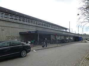
Sydhavn railway station
Commuter railway station in Copenhagen, Denmark
Distance: Approx. 841 meters
Latitude and longitude: 55.655,12.53777778
Sydhavn station is an S-train station serving the district of Kongens Enghave, commonly known as Sydhavnen ("South Harbour"), in southern Copenhagen, Denmark. The station is located on the Køge radial of Copenhagen's S-train network.
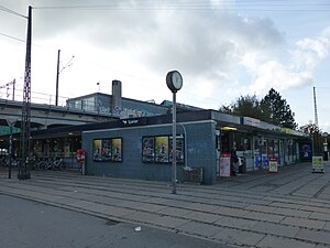
Sjælør railway station
Commuter railway station in Copenhagen, Denmark
Distance: Approx. 1115 meters
Latitude and longitude: 55.65166667,12.52694444
Sjælør station is an S-train railway station serving the southern part of the district of Valby in Copenhagen, Denmark. The station is located on the Køge radial of Copenhagen's S-train network.

Sluseholmen
Distance: Approx. 406 meters
Latitude and longitude: 55.64555556,12.54805556
Sluseholmen (lit. 'The Sluice Isle') is an artificial peninsula in the South Harbour of Copenhagen, Denmark. It takes its name from Slusen, a lock immediately to the south, regulating water levels in the harbor. Previously the site of heavy industry and part of the Southern Docklands of Port of Copenhagen, Sluseholmen has, since the turn of the millennium, undergone massive redevelopment, transforming it into a mainly residential district known for its canals and maritime atmosphere.

Teglholmen
Distance: Approx. 777 meters
Latitude and longitude: 55.65,12.55555556
Teglholmen (English: The Tiles Islet) is a peninsula in the South Harbour of Copenhagen, Denmark, located between Sluseholmen and Enghave Brygge. The former dockland area used to house heavy industry. While some industry activities remain in the area, but since most industry left the area, starting in the 1970s, it has undergone massive redevelopment, though some industrial activities remain, most notably MAN B&W Diesel's motor development plant.

DieselHouse
Diesel technology museum in Copenhagen
Distance: Approx. 1177 meters
Latitude and longitude: 55.6565,12.5552
DieselHouse is an interactive exhibition on diesel technology located on the grounds of the still operating H. C. Ørsted Power Station in the South Docklands of Copenhagen, Denmark. The exhibition is centred on a gigantic decommissioned Burmeister & Wain diesel engine which was the world's largest for more than 30 years.

H. C. Ørsted Power Station
Distance: Approx. 1278 meters
Latitude and longitude: 55.65685278,12.55696389
H. C. Ørsted Power Station (Danish: H. C. Ørstedværket) is a natural gas fired combined heat and power station located at Enghave Brygge, Sydhavnen in Copenhagen, Denmark. It is owned and operated by Ørsted. It is named after the Danish physicist Hans Christian Ørsted, the discoverer of electromagnetism.

Slusen, Copenhagen
Distance: Approx. 825 meters
Latitude and longitude: 55.6427,12.5524
Slusen (literally "The Sluice") is a lock in the South Harbour of Copenhagen, Denmark. It regulates water levels and inhibits unfavourable currents in the Copenhagen Harbour, occupying both sides of the narrow strait between Zealand and Amager. It lends its name to the adjacent Sluseholmen neighbourhood.

Nokken, Copenhagen
Distance: Approx. 1265 meters
Latitude and longitude: 55.65166667,12.56277778
Nokken is a self-built community located on the north-west coast of Amager, just south of Islands Brygge, in Copenhagen, Denmark.
Frederiks Brygge
Waterfront area in Copenhagen, Denmark
Distance: Approx. 806 meters
Latitude and longitude: 55.655,12.548
Frederiks Brygge (literally: Frederik's Quay") is a waterfront area in the Southern Docklands of Copenhagen, Denmark. It is located at the bottom of Frederiksholmsløbet, a canal that separates Enghave Brygge to the north from Teglholmen to the south.
Enghave Brygge station
Copenhagen metro station
Distance: Approx. 1190 meters
Latitude and longitude: 55.6475,12.5625
Enghave Brygge station is an underground Copenhagen Metro station, located in the eponymous area of Copenhagen, Denmark. The station is on the M4 Line, between Havneholmen and Sluseholmen.
Sluseholmen station
Copenhagen metro station
Distance: Approx. 269 meters
Latitude and longitude: 55.64583333,12.54444444
Sluseholmen station is an underground Copenhagen Metro station in the eponymous neighborhood of Copenhagen, Denmark. The station is on the M4 Line, between Enghave Brygge and Mozarts Plads.
Mozarts Plads station
Copenhagen metro station
Distance: Approx. 1308 meters
Latitude and longitude: 55.65666667,12.52916667
Mozarts Plads station is an underground Copenhagen Metro station located at the eponymous urban square in Copenhagen, Denmark. The station is on the M4 Line, between Sluseholmen and Copenhagen South.
Weather in this IP's area
light rain
9 Celsius
7 Celsius
8 Celsius
10 Celsius
1013 hPa
80 %
1013 hPa
1013 hPa
10000 meters
5.66 m/s
230 degree
75 %
07:32:43
18:19:56