Country:
 Denmark
Region:
City:
Latitude and Longitude:
Time Zone:
Postal Code:
IP information under different IP Channel
ip-api
Country
Region
City
ASN
Time Zone
ISP
Blacklist
Proxy
Latitude
Longitude
Postal
Route
IPinfo
Country
Region
City
ASN
Time Zone
ISP
Blacklist
Proxy
Latitude
Longitude
Postal
Route
MaxMind
Country
Region
City
ASN
Time Zone
ISP
Blacklist
Proxy
Latitude
Longitude
Postal
Route
Luminati
Country
DKRegion
83
City
odense
ASN
Time Zone
Europe/Copenhagen
ISP
Telenor A/S
Latitude
Longitude
Postal
db-ip
Country
Region
City
ASN
Time Zone
ISP
Blacklist
Proxy
Latitude
Longitude
Postal
Route
ipdata
Country
Region
City
ASN
Time Zone
ISP
Blacklist
Proxy
Latitude
Longitude
Postal
Route
Popular places and events near this IP address

Funen County
County of Denmark
Distance: Approx. 3620 meters
Latitude and longitude: 55.38111111,10.43527778
Funen County (Danish: Fyns Amt) is a former county (Danish: amt) in central Denmark, comprising the islands of Funen, Langeland, Tåsinge, Ærø, and approximately 90 other islands, of which only 25 are inhabited. The county was formed on 1 April 1970, comprising the former counties of Odense and Svendborg. The county was abolished from 1 January 2007, when it merged into Region of Southern Denmark (Region Syddanmark).

Odense River
River in Denmark
Distance: Approx. 3059 meters
Latitude and longitude: 55.43695,10.42276389
The Odense River (Danish: Odense Å) is a river located on the island of Funen, in central Denmark. It is about 60 kilometres (37 mi) long and is named after the Funish capital, Odense, which it passes through. Boats can be rented by the river, offering a scenic ride to Fruens Bøge.

Skibhusene
Suburb in Odense Municipality, Southern Denmark, Denmark
Distance: Approx. 2539 meters
Latitude and longitude: 55.42611111,10.41361111
Skibhusene is a small village and northeastern suburb of Odense, Denmark. The village is located at the end of Skibhusvej south of Odense Canal and industrial buildings. During the last decades the city of Odense has engulfed the village and today it is de facto a part of Odense.

Vollsmose
Suburb of Odense, Denmark
Distance: Approx. 981 meters
Latitude and longitude: 55.40833333,10.43333333
Vollsmose is a suburb of Odense, the third-largest city in Denmark. Approximately 3 km northeast of central Odense, towards Odense Fjord. It has around 10.000 inhabitants and is characterised by a modern housing development project from the 1970s.
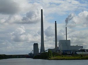
Fyn Power Station
Distance: Approx. 2921 meters
Latitude and longitude: 55.42980556,10.411
The Fyn Power Station (Danish: Fynsværket) is a coal, straw, and municipal waste-fired power station operated by Vattenfall in Odense, Denmark. It has eight units, three of which were operating as of 2010: unit 3, unit 7, and unit 8. Unit 3 has a power of 235 MW (coal), unit 7 of 362 MW (coal), unit 8 of 35 MW biomass), and Odense CHP plant 24 MW. Unit 7 has a 235 metres (771 ft) tall chimney, making it the second-tallest chimney in Denmark.

Rosengårdcentret
Shopping centre in Odense, Denmark
Distance: Approx. 3545 meters
Latitude and longitude: 55.38333333,10.42611111
Rosengårdcentret is a shopping centre located in Odense on the Danish island of Funen. The mall dates from 1971 and is the largest in Denmark with 144,000 m2 (1,550,000 sq ft) of floor space and more than 150 stores as well as restaurants, a cinema and a fitness centre.

Agedrup
Village in Southern Denmark, Denmark
Distance: Approx. 3401 meters
Latitude and longitude: 55.43222222,10.48833333
Agedrup is a village and northeastern suburb of Odense, Funen, Denmark. It contains a church, Agedrup Church (Agedrup Kirke).
Åsum, Denmark
Town in Southern Denmark, Denmark
Distance: Approx. 1786 meters
Latitude and longitude: 55.4,10.46305556
Åsum is a village and eastern suburb of Odense, Funen, Denmark. Aasum Church is located in the village.

Bullerup
Village in Southern Denmark, Denmark
Distance: Approx. 1275 meters
Latitude and longitude: 55.4225,10.45777778
Bullerup is a village and northeastern suburb of Odense, Funen, Denmark. It is located near Agedrup and Seden.
Seden
Village in Southern Denmark, Denmark
Distance: Approx. 1701 meters
Latitude and longitude: 55.42805556,10.44194444
Seden is a large village and northeastern suburb of Odense, in Funen, Denmark. The Suburb has a population of 3.743 It borders Vollsmose to the south and Stige to the north and Kerteminde to the east.
Rosengård, Odense
Neighbourhood in Odense Municipality, Southern Denmark, Denmark
Distance: Approx. 3376 meters
Latitude and longitude: 55.38361111,10.43333333
Rosengård is a southeastern neighbourhood of Odense, in Funen, Denmark. It contains the Rosengårdcentret buildings.
Marienlystcentret
Football stadium in Denmark
Distance: Approx. 3369 meters
Latitude and longitude: 55.42194444,10.39555556
Marienlystcentret is a sports complex located in Odense, Denmark. Its main venue is the stadium, which has a capacity of 1,200 and is home to the association football department of BK Marienlyst, which plays in the fourth-tier Denmark Series. The complex also contains an arena where the volleyball team and other sports teams are located.
Weather in this IP's area
broken clouds
10 Celsius
7 Celsius
10 Celsius
10 Celsius
1013 hPa
74 %
1013 hPa
1013 hPa
10000 meters
6.23 m/s
12.29 m/s
246 degree
72 %
07:40:47
18:28:39