Country:
Region:
City:
Latitude and Longitude:
Time Zone:
Postal Code:
IP information under different IP Channel
ip-api
Country
Region
City
ASN
Time Zone
ISP
Blacklist
Proxy
Latitude
Longitude
Postal
Route
Luminati
Country
ASN
Time Zone
Europe/Berlin
ISP
ISPpro Internet KG
Latitude
Longitude
Postal
IPinfo
Country
Region
City
ASN
Time Zone
ISP
Blacklist
Proxy
Latitude
Longitude
Postal
Route
db-ip
Country
Region
City
ASN
Time Zone
ISP
Blacklist
Proxy
Latitude
Longitude
Postal
Route
ipdata
Country
Region
City
ASN
Time Zone
ISP
Blacklist
Proxy
Latitude
Longitude
Postal
Route
Popular places and events near this IP address

Ostrhauderfehn
Municipality in Lower Saxony, Germany
Distance: Approx. 5658 meters
Latitude and longitude: 53.11666667,7.61666667
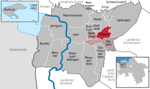
Ostrhauderfehn is a municipality in the Leer district of Lower Saxony, Germany. It split from Rhauderfehn sometime between 1820 and 1830. Ostrhauderfehn was for many years one of the largest municipalities in the district of Leer.

Rhauderfehn
Municipality in Lower Saxony, Germany
Distance: Approx. 6268 meters
Latitude and longitude: 53.16666667,7.55
Rhauderfehn is a municipality in the Leer district, in Lower Saxony, Germany.

Filsum
Municipality in Lower Saxony, Germany
Distance: Approx. 7661 meters
Latitude and longitude: 53.23333333,7.63333333
Filsum is a small municipality in the Leer district, in the North West of Germany. The municipality lies approximately 30 km from the Netherlands border, and 50 km from where the coast meets the North Sea. It is home to the 'horse whisperer' and bonesetter, Tamme Hanken.
Potshausen
Distance: Approx. 2748 meters
Latitude and longitude: 53.18333333,7.61666667
Potshausen is part of Ostrhauderfehn, a municipality in Leer district, Lower Saxony, Germany. Potshausen is famous in northern Germany for its Evangelisch Ostfriesische Landvolkshochschule. This is a school for public education, primarily for adults, but also providing a private school for those pupils who are not able to finish at public schools.

Jümme
Samtgemeinde in Lower Saxony, Germany
Distance: Approx. 7661 meters
Latitude and longitude: 53.23333333,7.63333333
Jümme is a collective municipality (Samtgemeinde) in the district of Leer in the German state of Lower Saxony. It is named after the River Jümme which flows through all three constituent communities. It has an area of 82.34 km2 and a population of 6,421.

Barßel
Municipality in Lower Saxony, Germany
Distance: Approx. 6887 meters
Latitude and longitude: 53.17027778,7.74666667
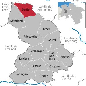
Barßel is a municipality in the district of Cloppenburg, in Lower Saxony, Germany.

Soeste
River in Germany
Distance: Approx. 3432 meters
Latitude and longitude: 53.1816,7.687
Soeste is a river in the Cloppenburg district in Lower Saxony, Germany, a tributary of the Ems. The Soeste forms from two source brooks in Hesselnfeld and Egterholz, two small settlements in the Emstek municipality. It flows northwest through Cloppenburg, where its water flow is already sufficient for water mills to be operated im former times.
Detern
Municipality in Lower Saxony, Germany
Distance: Approx. 7661 meters
Latitude and longitude: 53.23333333,7.63333333
Detern is a municipality in the district of Leer, in Lower Saxony, Germany. The Battle of Detern was fought here in 1426.

Nordgeorgsfehn Canal
Distance: Approx. 5816 meters
Latitude and longitude: 53.21666667,7.63333333
The Nordgeorgsfehn Canal (German: Nordgeorgsfehnkanal or NGFK) is a canal in East Frisia, Lower Saxony, Germany. It connects the Jümme with the Ems-Jade Canal. It is 31.8 km long and 13 m wide.

Aper Tief
River in Lower Saxony, Germany
Distance: Approx. 5042 meters
Latitude and longitude: 53.20528,7.67778
The Aper Tief is a stream in Lower Saxony, Germany. It flows through the municipalities of Apen (district of Ammerland) and Detern in the collective municipality of Jümme (district of Leer). It begins west of Apen at the confluence of the Große Süderbäke and the Große Norderbäke, runs roughly east–west and empties south of the municipality of Detern into the Jümme.

Sagter Ems
River in Germany
Distance: Approx. 2360 meters
Latitude and longitude: 53.1778,7.6718
Sagter Ems is a river of Lower Saxony, Germany. It is formed at the confluence of the rivers Ohe and Marka west of Friesoythe. It is 28 km long.
East Frisian Geest
Distance: Approx. 4093 meters
Latitude and longitude: 53.15,7.7
The East Frisian Geest (German: Ostfriesisch-Oldenburgische Geest) is a natural region major unit group (not quite synonymous with a "major region of the third level") in northwest Germany and northwestern Lower Saxony. Its character consists in the very varied juxtaposition of different landscape elements of the Northern Lowlands of which the East Frisian Geest is a part.
Weather in this IP's area
overcast clouds
8 Celsius
5 Celsius
7 Celsius
8 Celsius
1008 hPa
96 %
1008 hPa
1008 hPa
10000 meters
4.5 m/s
9.61 m/s
253 degree
100 %
07:58:02
16:31:09
