85.254.155.16 - IP Lookup: Free IP Address Lookup, Postal Code Lookup, IP Location Lookup, IP ASN, Public IP
Country:
Region:
City:
Location:
Time Zone:
Postal Code:
IP information under different IP Channel
ip-api
Country
Region
City
ASN
Time Zone
ISP
Blacklist
Proxy
Latitude
Longitude
Postal
Route
Luminati
Country
ASN
Time Zone
Europe/Riga
ISP
UAB Bite Lietuva
Latitude
Longitude
Postal
IPinfo
Country
Region
City
ASN
Time Zone
ISP
Blacklist
Proxy
Latitude
Longitude
Postal
Route
IP2Location
85.254.155.16Country
Region
marupes novads
City
pinki
Time Zone
Europe/Riga
ISP
Language
User-Agent
Latitude
Longitude
Postal
db-ip
Country
Region
City
ASN
Time Zone
ISP
Blacklist
Proxy
Latitude
Longitude
Postal
Route
ipdata
Country
Region
City
ASN
Time Zone
ISP
Blacklist
Proxy
Latitude
Longitude
Postal
Route
Popular places and events near this IP address

Riga International Airport
Airport in Latvia
Distance: Approx. 4191 meters
Latitude and longitude: 56.92361111,23.97111111
RIX Riga Airport (Latvian: RIX Rīgas lidosta; IATA: RIX, ICAO: EVRA) is the international airport of Riga, the capital of Latvia, and the largest airport in the Baltic states with direct flights to 107 destinations as of September 2024. It serves as a hub for airBaltic, SmartLynx Airlines and RAF-Avia, and as one of the base airports for Ryanair. The Latvian national carrier airBaltic is the largest carrier that serves the airport, followed by Ryanair.

Beberbeķi
Neighbourhood of Riga, Latvia
Distance: Approx. 2545 meters
Latitude and longitude: 56.95,23.95
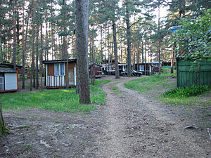
Beberbeķi is a neighbourhood consisting mainly of private houses which lies on the western edge of Riga, Latvia. The swampy forest in Mūķupurvs and the Rīga International Airport noise area divides it from the rest of the city. Within the neighborhood is Beberbeķi Park, which contains a small lake used as a beach and ice fishing.

Riga Aviation Museum
Museum in Riga, Latvia
Distance: Approx. 3923 meters
Latitude and longitude: 56.91888889,23.95972222
Riga Aviation Museum is an aviation museum in Riga, Latvia.

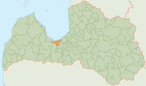
Babīte Municipality
Municipality of Latvia
Distance: Approx. 2545 meters
Latitude and longitude: 56.95,23.95
Babīte Municipality (Latvian: Babītes novads) is a former municipality in Latvia. The municipality was formed in 2009 when Babīte parish and Sala parish merged with the administrative centre becoming Piņķi.
International School of Latvia
School in Jurmala, Latvia
Distance: Approx. 482 meters
Latitude and longitude: 56.94527778,23.90583333
The International School of Latvia founded in 1994, is an independent co-educational, non-profit, college preparatory day school, for students of all nationalities 2 – 18 years of age. The International School of Latvia is an English language learning environment. It is a 15-minute drive from the center of Riga in the township of Piņķi, near the coastal resort of Jūrmala.

Mūkupurvs
Neighbourhood of Riga, Latvia
Distance: Approx. 4270 meters
Latitude and longitude: 56.9383,23.9808
Mūkupurvs is a neighborhood of the city of Riga, the capital city of Latvia and in Pārdaugava, a suburb of Zemgale. Mūkupurva neighborhood is located in the R part of Riga. It borders Beberbekai, Zolitūde and Pleskodāle neighborhoods, as well as Mārupe parish of Mārupe county, which is adjacent to the D part of Mūkupurva neighborhood.

Piņķi
Village in Latvia
Distance: Approx. 283 meters
Latitude and longitude: 56.94444444,23.91083333
Piņķi is a village in Mārupe Municipality, Latvia. Piņķi had 3,527 residents as of 2024. The village has 4 schools in total, including Babīte Secondary School, public, and three international schools: Exupéry International School, King's College Latvia, and The International School of Latvia.
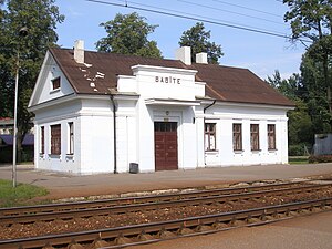
Babīte Station
Railway station in Latvia
Distance: Approx. 3073 meters
Latitude and longitude: 56.95727778,23.95283056
Babīte Station is a railway station on the Torņakalns – Tukums II Railway.
Priedaine Station
Railway station in Jūrmala, Latvia
Distance: Approx. 3605 meters
Latitude and longitude: 56.97157222,23.88701944
Priedaine Station is a railway station on the Torņakalns – Tukums II Railway in the Priedaine neighbourhood of Jūrmala, Latvia.

Bražciems
Neighbourhood of Jūrmala, Latvia
Distance: Approx. 3844 meters
Latitude and longitude: 56.96666667,23.86666667
Bražciems (also Bražuciems, Bražas) is a residential area and neighbourhood of the city Jūrmala, Latvia.

Priedaine
Neighborhood of Jurmala, Latvia
Distance: Approx. 3718 meters
Latitude and longitude: 56.97416667,23.895
Priedaine is a residential area and neighbourhood of the city Jūrmala, Latvia. The Priedaine railway station was established in 1909.

Stirnurags
Neighbourhood of Jurmala, Latvia
Distance: Approx. 4904 meters
Latitude and longitude: 56.98333333,23.88333333
Stirnurags is a residential area and neighbourhood of the city Jūrmala, Latvia.
Weather in this IP's area
fog
-1 Celsius
-5 Celsius
-1 Celsius
-1 Celsius
1016 hPa
100 %
1016 hPa
1015 hPa
1100 meters
3.09 m/s
210 degree
100 %

