Country:
 Slovakia
Region:
City:
Latitude and Longitude:
Time Zone:
Postal Code:
IP information under different IP Channel
ip-api
Country
Region
City
ASN
Time Zone
ISP
Blacklist
Proxy
Latitude
Longitude
Postal
Route
IPinfo
Country
Region
City
ASN
Time Zone
ISP
Blacklist
Proxy
Latitude
Longitude
Postal
Route
MaxMind
Country
Region
City
ASN
Time Zone
ISP
Blacklist
Proxy
Latitude
Longitude
Postal
Route
Luminati
Country
SKRegion
ta
City
dunajskastreda
ASN
Time Zone
Europe/Bratislava
ISP
TomaNet s.r.o.
Latitude
Longitude
Postal
db-ip
Country
Region
City
ASN
Time Zone
ISP
Blacklist
Proxy
Latitude
Longitude
Postal
Route
ipdata
Country
Region
City
ASN
Time Zone
ISP
Blacklist
Proxy
Latitude
Longitude
Postal
Route
Popular places and events near this IP address
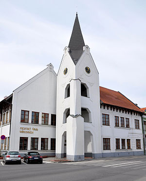
Dunajská Streda
Town in Žitný ostrov, Slovakia
Distance: Approx. 588 meters
Latitude and longitude: 47.99444444,17.61944444
Dunajská Streda (Slovak pronunciation: [ˈdunajskaː ˈstreda] ; Hungarian: Dunaszerdahely; German: Niedermarkt; is a town located in southern Slovakia (Trnavský kraj). Dunajská Streda is the most culturally significant town in the Žitný ostrov area. The town has a population of 22,730, with ethnic Hungarians forming the 72% majority.
Vydrany
Village in Trnava, Slovakia
Distance: Approx. 3527 meters
Latitude and longitude: 48.01666667,17.5875
Vydrany (Hungarian: Nemeshódos, pronounced [nɛmɛʃhoːdoʃ], until 1899 Hódos) is a village and municipality in the Dunajská Streda District in the Trnava Region of south-west Slovakia. .
Dunajská Streda District
District in Trnava Region, Slovakia
Distance: Approx. 302 meters
Latitude and longitude: 47.9925,17.61694444
Dunajská Streda District (Slovak: Okres Dunajská Streda, Hungarian: Dunaszerdahelyi járás) is a district in the Trnava Region of western Slovakia. Until 1918, the district was mostly part of the county of Kingdom of Hungary of Pozsony, apart from a small area in the south, which formed part of the county of Komárno, and Baloň, which formed part of the county of Győr. The majority of the inhabitants of Dunajská Streda District are Hungarians.

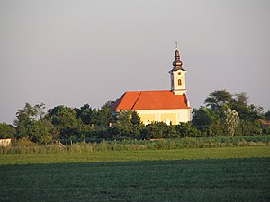
MOL Aréna
Football stadium in Dunajská Streda, Slovakia
Distance: Approx. 983 meters
Latitude and longitude: 47.99888889,17.61833333
MOL Aréna is a football stadium in Dunajská Streda, Slovakia. It is the home ground of a local club FC DAC 1904 Dunajská Streda and has an all-seated capacity of 12,700 people. The intensity of the floodlighting is 1,800 lux.
Povoda
Village in Trnava, Slovakia
Distance: Approx. 2779 meters
Latitude and longitude: 47.97361111,17.64166667
Povoda (Hungarian: Pódatejed, pronounced [ˈpoːdɒtɛjɛd]) is a village and municipality in the Dunajská Streda District in the Trnava Region of south-west Slovakia.
Kráľovičove Kračany
Village in Trnava, Slovakia
Distance: Approx. 4485 meters
Latitude and longitude: 47.9875,17.55416667
Kráľovičove Kračany (Hungarian: Királyfiakarcsa, pronounced [ˈkiraːjfiɒkɒrtʃɒ]) is a village and municipality in the Dunajská Streda District in the Trnava Region of south-west Slovakia.
Kostolné Kračany
Village in Trnava, Slovakia
Distance: Approx. 2900 meters
Latitude and longitude: 47.98361111,17.57666667
Kostolné Kračany (Hungarian: Egyházkarcsa, pronounced [ˈɛɟhaːzkɒrtʃɒ]) is a village and municipality in the Dunajská Streda District in the Trnava Region of south-west Slovakia.
Kútniky
Village in Trnava, Slovakia
Distance: Approx. 3801 meters
Latitude and longitude: 47.97666667,17.66083333
Kútniky (Hungarian: Hegyéte, pronounced [ˈhɛɟeːtɛ]) is a village and municipality in the Dunajská Streda District in the Trnava Region of south-west Slovakia.
Malé Dvorníky
Village in Trnava, Slovakia
Distance: Approx. 3144 meters
Latitude and longitude: 48.01111111,17.64305556
Malé Dvorníky (Hungarian: Kisudvarnok, pronounced [ˈkiʃudvɒrnok]) is a village and municipality in the Dunajská Streda District in the Trnava Region of south-west Slovakia.

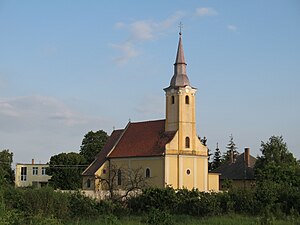
Dolný Štál
Village in Trnava, Slovakia
Distance: Approx. 2900 meters
Latitude and longitude: 47.98361111,17.57666667
Dolný Štál (Hungarian: Alistál, pronounced [ˈɒliʃtaːl]) is a village and municipality in the Dunajská Streda District in the Trnava Region of south-west Slovakia.
Veľké Blahovo
Village in Trnava, Slovakia
Distance: Approx. 3475 meters
Latitude and longitude: 48.01111111,17.57916667
Veľké Blahovo (Hungarian: Nagyabony, pronounced [ˈnɒɟɒboɲ]) is a village and municipality in the Dunajská Streda District in the Trnava Region of south-west Slovakia. Until 1899 its Hungarian name was Nagy-Abony, then Nemesabony, but recently the Nagyabony form has come into usage.
Veľké Dvorníky
Village in Trnava, Slovakia
Distance: Approx. 2869 meters
Latitude and longitude: 48,17.65
Veľké Dvorníky (Hungarian: Nagyudvarnok, pronounced [ˈnɒɟudvrnok]) is a village and municipality in the Dunajská Streda District in the Trnava Region of south-west Slovakia. Its former Slovak name is Dvorníky na Ostrove.
Weather in this IP's area
few clouds
15 Celsius
15 Celsius
14 Celsius
17 Celsius
1022 hPa
85 %
1022 hPa
1008 hPa
10000 meters
3.52 m/s
10 m/s
64 degree
16 %
06:32:25
18:54:12