Country:
Region:
City:
Latitude and Longitude:
Time Zone:
Postal Code:
IP information under different IP Channel
ip-api
Country
Region
City
ASN
Time Zone
ISP
Blacklist
Proxy
Latitude
Longitude
Postal
Route
Luminati
Country
ASN
Time Zone
Europe/Prague
ISP
Slovak Telekom, a.s.
Latitude
Longitude
Postal
IPinfo
Country
Region
City
ASN
Time Zone
ISP
Blacklist
Proxy
Latitude
Longitude
Postal
Route
db-ip
Country
Region
City
ASN
Time Zone
ISP
Blacklist
Proxy
Latitude
Longitude
Postal
Route
ipdata
Country
Region
City
ASN
Time Zone
ISP
Blacklist
Proxy
Latitude
Longitude
Postal
Route
Popular places and events near this IP address

Svitava (river)
River in South Moravian, Czech Republic
Distance: Approx. 1985 meters
Latitude and longitude: 49.14222222,16.62833333
The Svitava (German: Zwittawa) is a river in the Czech Republic, a left tributary of the Svratka River. It flows through the Pardubice and South Moravian regions. It is 98.4 km (61.1 mi) long.

Modřice
Town in South Moravian, Czech Republic
Distance: Approx. 2374 meters
Latitude and longitude: 49.12805556,16.61444444
Modřice (Czech pronunciation: [ˈmodr̝ɪtsɛ]; German: Mödritz) is a town in Brno-Country District in the South Moravian Region of the Czech Republic. It has about 5,700 inhabitants.

South Moravian Region
Region of the Czech Republic
Distance: Approx. 2512 meters
Latitude and longitude: 49.16666667,16.58333333
The South Moravian Region (Czech: Jihomoravský kraj; German: Südmährische Region, pronounced [zyːtˈmɛːʁɪʃə ʁeˈɡi̯oːn]; Slovak: Juhomoravský kraj), or just South Moravia, is an administrative unit (kraj) of the Czech Republic, located in the south-western part of its historical region of Moravia (an exception is Jobova Lhota which traditionally belongs to Bohemia). The region's capital is Brno, the nation's 2nd largest city. South Moravia is bordered by the South Bohemian Region to the west, Vysočina Region to the north-west, Pardubice Region to the north, Olomouc Region to the north-east, Zlín Region to the east, Trenčín and Trnava Regions, Slovakia to the south-east and Lower Austria, Austria to the south.

Brno-Bohunice
City District of Brno in South Moravia, Czech Republic
Distance: Approx. 2939 meters
Latitude and longitude: 49.16944444,16.57916667
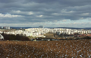
Brno-Bohunice is a city district of Brno, the second largest city in the Czech Republic. It is made up of the cadastral territory of Bohunice. It is located in the southwest part of the city.

Moravany (Brno-Country District)
Municipality in South Moravian, Czech Republic
Distance: Approx. 1939 meters
Latitude and longitude: 49.14555556,16.57611111
Moravany (German: Morbes) is a municipality and village in Brno-Country District in the South Moravian Region of the Czech Republic. It has about 3,500 inhabitants.

Nebovidy (Brno-Country District)
Municipality in South Moravian, Czech Republic
Distance: Approx. 3792 meters
Latitude and longitude: 49.14138889,16.55138889
Nebovidy is a municipality and village in Brno-Country District in the South Moravian Region of the Czech Republic. It has about 900 inhabitants. Nebovidy lies approximately 9 kilometres (6 mi) south-west of Brno and 186 km (116 mi) south-east of Prague.
Želešice
Municipality in South Moravian, Czech Republic
Distance: Approx. 3802 meters
Latitude and longitude: 49.11666667,16.58138889
Želešice is a municipality and village in Brno-Country District in the South Moravian Region of the Czech Republic. It has about 1,900 inhabitants. Želešice lies approximately 10 kilometres (6 mi) south of Brno and 190 km (120 mi) south-east of Prague.

AZ Tower
Distance: Approx. 3117 meters
Latitude and longitude: 49.17583333,16.60555556
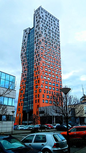
The AZ Tower is a high rise building in the city of Brno, Czech Republic. The tower is 111 m (364 ft) tall, and it has 30 floors. It is currently the tallest building in the Czech Republic.

Spielberk Towers
Distance: Approx. 3830 meters
Latitude and longitude: 49.18222222,16.60611111
Spielberk Towers are two high-rises in Brno, Czech Republic. The towers are part of the complex Spielberk Office Centre. The towers are named as Tower A and Tower B. The lower tower is named Tower A and the taller tower is named Tower B. The Tower A is 53 metres high and the taller Tower B is 85 metres high.

M-Palace
Office in Brno, Czech Republic
Distance: Approx. 3266 meters
Latitude and longitude: 49.17720556,16.60456444
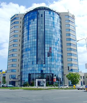
M-Palace (Czech: M-Palác) is a high-rise building in Brno, Czech Republic. The building is 60 meters high and it is one of the tallest buildings in Brno. The building consists of a sixteen-floors tower and two-floors building.

Brno-jih
City District of Brno in South Moravian Region, Czech Republic
Distance: Approx. 3303 meters
Latitude and longitude: 49.17444444,16.62277778
Brno-jih (lit. 'Brno-South') is a city district of Brno in the Czech Republic. The current city district was established on 24 November 1990.

Brno-Starý Lískovec
City District of Brno in South Moravian Region, Czech Republic
Distance: Approx. 3769 meters
Latitude and longitude: 49.16916667,16.56222222
Brno-Starý Lískovec is a city district of Brno, Czech Republic, located on the southwestern edge of the city. It consists of most of the cadastral territory of Starý Lískovec (German: Alt Leskau, lit. 'Old Lískovec'), which has all of the city district's population, along with a small part of Nový Lískovec (German: Neu Leskau), originally the municipality of Lískovec (German: Leskau), which was annexed to Brno in 1919.
Weather in this IP's area
overcast clouds
8 Celsius
6 Celsius
7 Celsius
9 Celsius
1026 hPa
71 %
1026 hPa
1000 hPa
10000 meters
3.13 m/s
320 degree
100 %
07:04:04
16:12:38
