Country:
 Netherlands
Region:
City:
Latitude and Longitude:
Time Zone:
Postal Code:
IP information under different IP Channel
ip-api
Country
Region
City
ASN
Time Zone
ISP
Blacklist
Proxy
Latitude
Longitude
Postal
Route
IPinfo
Country
Region
City
ASN
Time Zone
ISP
Blacklist
Proxy
Latitude
Longitude
Postal
Route
MaxMind
Country
Region
City
ASN
Time Zone
ISP
Blacklist
Proxy
Latitude
Longitude
Postal
Route
Luminati
Country
NLRegion
nb
City
shertogenbosch
ASN
Time Zone
Europe/Amsterdam
ISP
IP Visie Networking B.V.
Latitude
Longitude
Postal
db-ip
Country
Region
City
ASN
Time Zone
ISP
Blacklist
Proxy
Latitude
Longitude
Postal
Route
ipdata
Country
Region
City
ASN
Time Zone
ISP
Blacklist
Proxy
Latitude
Longitude
Postal
Route
Popular places and events near this IP address

De Vliert
Soccer stadium in the Netherlands
Distance: Approx. 1973 meters
Latitude and longitude: 51.70166667,5.32972222
De Vliert (Dutch pronunciation: [də ˈvliːrt]) is a multi-use stadium in 's-Hertogenbosch, Netherlands. It is currently used mostly for football matches and is the home stadium of FC Den Bosch. The original stadium was built in 1951, included an athletics track and had at its heyday a capacity of 30,000, making it one of the largest stadiums in the Netherlands.

Empel
Place in North Brabant, Netherlands
Distance: Approx. 1576 meters
Latitude and longitude: 51.73111111,5.32722222
Empel is a village and former municipality, which is now a quarter of 's-Hertogenbosch in the Dutch province of North Brabant.

Empel en Meerwijk
Former municipality in North Brabant, Netherlands
Distance: Approx. 2168 meters
Latitude and longitude: 51.73555556,5.305
Empel en Meerwijk is a former municipality of the Dutch province of North Brabant.

Maaspoort
Indoor arena in Den Bosch, Netherlands
Distance: Approx. 562 meters
Latitude and longitude: 51.72267778,5.31551944
The Maaspoort (English: Meuse Gate) is an indoor arena in 's-Hertogenbosch, Netherlands. Opened on 2 September 1982, it has a seating capacity for 3,500 people in sporting events and 4,000 for concerts. It is the regular home venue of the Heroes Den Bosch basketball club.

's-Hertogenbosch Oost railway station
Railway station in the Netherlands
Distance: Approx. 1942 meters
Latitude and longitude: 51.70055556,5.31888889
's-Hertogenbosch Oost railway station serves the city of 's-Hertogenbosch in the North Brabant province of the Netherlands.
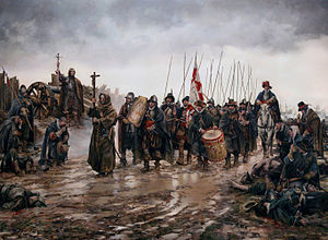
Battle of Empel
Battle
Distance: Approx. 1576 meters
Latitude and longitude: 51.73111111,5.32722222
The Miracle of Empel (Milagro de Empel in Spanish) was an unexpected Spanish victory on December 8, 1585, near Empel, in the Netherlands, as part of the Eighty Years' War, in which a surrounded Spanish force managed to escape when the waters around their island suddenly froze.
Heroes Den Bosch
Basketball team in 's-Hertogenbosch, Netherlands
Distance: Approx. 562 meters
Latitude and longitude: 51.72267778,5.31551944
Heroes Den Bosch is a Dutch professional basketball club based in 's-Hertogenbosch. The club plays in the BNXT League since 2021 and in the top basketball division in the Netherlands since 1972. Founded as EBBC in 1951, the club had several sponsored names the following decades.

Siege of 's-Hertogenbosch (1601)
1601 siege
Distance: Approx. 2008 meters
Latitude and longitude: 51.7,5.31666944
The siege of 's-Hertogenbosch of 1601 (Sitio de Bolduque de 1601 in Spanish) was an unsuccessful Dutch attempt led by Prince Maurice of Nassau and William Louis of Nassau-Dillenburg to capture the city of 's-Hertogenbosch, North Brabant, Spanish Netherlands, garrisoned by about 1,500–2,000 Spanish soldiers (2 infantry companies and 2 cavalry companies) led by Governor Anthonie Schetz, Baron of Grobbendonck, between 1 and 27 November 1601, during the Eighty Years' War and the Anglo-Spanish War (1585–1604), in the context of the long and bloodiest siege of Ostend. After having captured Rheinberg in July 1601, Prince Maurice in October mobilized seventy-three companies of infantry and thirty-three companies of cavalry, including several pieces of artillery. The city was virtually impregnable due to the great defensive fortifications, the continuous arrival of fresh Spanish reinforcements, and the deep loyalty of the population to the Catholic cause.
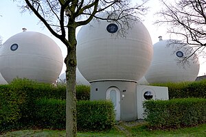
Bolwoningen
Dutch community in Den Bosch, Netherlands, consisting of 50 spherical houses
Distance: Approx. 1543 meters
Latitude and longitude: 51.7297,5.3066
Bolwoningen are Dutch spherical houses in the Maaspoort neighborhood of 's-Hertogenbosch, Netherlands. It consists of 50 spherical houses grouped together near to a canal.

Brabanthallen
Convention center in The Netherlands
Distance: Approx. 2739 meters
Latitude and longitude: 51.701111,5.289722
The Brabanthallen (Dutch pronunciation: [ˈbraːbɑntˌɦɑlə(n)]; literally "Brabant Halls") is a convention center in 's-Hertogenbosch, Netherlands. Every year, it hosts several exhibitions, conferences, trade fairs, concerts and other big events. It is the third largest convention center in the Netherlands, after RAI Amsterdam and Jaarbeurs Utrecht.

Citadel of 's-Hertogenbosch
Fortress in the Netherlands
Distance: Approx. 2740 meters
Latitude and longitude: 51.69527778,5.30333333
The Citadel of 's-Hertogenbosch is a fortress on the north side of the town center of 's Hertogenbosch in the Netherlands. It was constructed from 1637 to 1642.
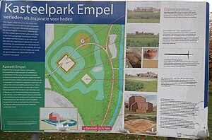
Empel en Meerwijk Castle
Distance: Approx. 1433 meters
Latitude and longitude: 51.730872,5.318331
Empel en Meerwijk Castle was a medieval castle just north of 's-Hertogenbosch. All that's left is a terrain where the castle outlines have been visualized.
Weather in this IP's area
scattered clouds
20 Celsius
20 Celsius
19 Celsius
21 Celsius
1007 hPa
66 %
1007 hPa
1006 hPa
10000 meters
3.79 m/s
7.89 m/s
193 degree
44 %
07:02:51
20:10:09