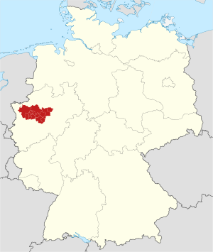
Country:
 Germany
Region:
City:
Latitude and Longitude:
Time Zone:
Postal Code:
IP information under different IP Channel
ip-api
Country
Region
City
ASN
Time Zone
ISP
Blacklist
Proxy
Latitude
Longitude
Postal
Route
IPinfo
Country
Region
City
ASN
Time Zone
ISP
Blacklist
Proxy
Latitude
Longitude
Postal
Route
MaxMind
Country
Region
City
ASN
Time Zone
ISP
Blacklist
Proxy
Latitude
Longitude
Postal
Route
Luminati
Country
DERegion
nw
City
dortmund
ASN
Time Zone
Europe/Berlin
ISP
DOKOM Gesellschaft fuer Telekommunikation mbH
Latitude
Longitude
Postal
db-ip
Country
Region
City
ASN
Time Zone
ISP
Blacklist
Proxy
Latitude
Longitude
Postal
Route
ipdata
Country
Region
City
ASN
Time Zone
ISP
Blacklist
Proxy
Latitude
Longitude
Postal
Route
Popular places and events near this IP address
Ruhr
Urban area in North Rhine-Westphalia, Germany
Distance: Approx. 2060 meters
Latitude and longitude: 51.5,7.5
The Ruhr ( ROOR; German: Ruhrgebiet [ˈʁuːɐ̯ɡəˌbiːt] , also Ruhrpott German pronunciation: [ˈʁuːɐ̯pɔt] ), also referred to as the Ruhr area, sometimes Ruhr district, Ruhr region, or Ruhr valley, is a polycentric urban area in North Rhine-Westphalia, Germany. With a population density of 2,800/km2 and a population of over 5 million (2017), it is the largest urban area in Germany and the third of the European Union. It consists of several large cities bordered by the rivers Ruhr to the south, Rhine to the west, and Lippe to the north.

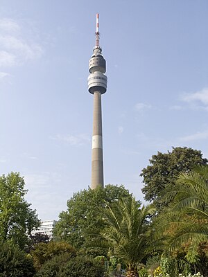
Florianturm
Telecommunications tower and landmark of Dortmund, Germany
Distance: Approx. 2483 meters
Latitude and longitude: 51.49638889,7.47638889
The Florianturm (Florian Tower, Florian for short) is a telecommunications tower and landmark of Dortmund (Germany). It is named after St. Florian, the patron saint of gardeners.
Hörde
Urban district of Dortmund, Germany
Distance: Approx. 294 meters
Latitude and longitude: 51.48333333,7.5
Hörde is a Stadtbezirk ("City District") and also a Stadtteil (Quarter) in the south of the city of Dortmund, in Germany. Hörde is situated at 51°29' North, 7°30' West, and is at an elevation of 112 metres above mean sea level. It is situated in the southern part of Dortmund, a major town in the Ruhrgebiet.

Botanischer Garten Rombergpark
Park in North Rhine-Westphalia, Germany
Distance: Approx. 2415 meters
Latitude and longitude: 51.4807,7.4684
Botanischer Garten Rombergpark (Rombergpark Botanical Garden), or informally Rombergpark, is an extensive municipal botanical garden and arboretum in Dortmund, North Rhine-Westphalia, Germany. With its total area of 68 hectares the Rombergpark is one of the largest botanical gardens in the world. It is always freely open.
Hansa Theater Hörde
Distance: Approx. 601 meters
Latitude and longitude: 51.48694444,7.50194444
Hansa Theater Hörde is a theatre in Dortmund, North Rhine-Westphalia, Germany.

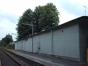
Dortmund-Hörde station
Railway station in Dortmund, Germany
Distance: Approx. 729 meters
Latitude and longitude: 51.48777778,7.49972222
Dortmund-Hörde station is a passenger station in the Dortmund district of Horde in the German state of North Rhine-Westphalia. It is classified by Deutsche Bahn as a category 4 station. It is owned by Deutsche Bahn and is located on the Dortmund–Soest railway.

Brünninghausen
Quarter of Dortmund, Germany
Distance: Approx. 2537 meters
Latitude and longitude: 51.4833,7.4667
Brünninghausen is a Stadtteil (Quarter) in the south of the city of Dortmund in Germany. It belongs to the Stadtbezirk ("City District") Hombruch. With a population of 3,913 and an area of 2.16 km2 it is one of the smaller parts of Dortmund.
Dortmund Zoo
Zoo in Dortmund, Germany
Distance: Approx. 2538 meters
Latitude and longitude: 51.472,7.47
The Dortmund Zoo is the zoological garden of Dortmund, Germany. It is specialized in the keeping and breeding of South American species and is leading in the breeding of the giant anteater, the tamandua and the giant otter. The zoo is situated in the south of the city between the boroughs of Hacheney and Brünninghausen.
Dortmund Tierpark station
Railway station in Germany
Distance: Approx. 2885 meters
Latitude and longitude: 51.47802,7.46199
Dortmund Tierpark station is a railway station in the Brünninghausen district of the town of Dortmund, located in North Rhine-Westphalia, Germany. The station Dortmund Tierpark is located on the Düsseldorf-Derendorf–Dortmund Süd railway built by the Rhenish Railway Company (German: Rheinische Eisenbahn-Gesellschaft, RhE) and now operated by Deutsche Bahn. The railroad line is single-track at the level of the station, for which reason the station has only one platform.
Westfalenpark
Public park in Dortmund, Germany
Distance: Approx. 2350 meters
Latitude and longitude: 51.495,7.477
The Westfalenpark is a large public park in Dortmund, Germany. With an area of 70 ha (170 acres), the park is one of the largest inner-city parks in Europe and is a popular destination for excursions and recreation in North Rhine-Westphalia. The park is situated between the Westfalenstadion, Westfalenhallen, Bundesautobahn 40 and includes the Florianturm.

Dortmunder Stadtwerke
Public transport company in Germany
Distance: Approx. 2931 meters
Latitude and longitude: 51.50559722,7.48578333
Dortmunder Stadtwerke AG is a municipal services and public transport company in Dortmund, wholly owned by the city of Dortmund. It is operating under the brand DSW21 since 2005. The number in the acronym refers to the 21st century.
Goethe-Gymnasium, Dortmund
Gymnasium and secondary school in Dortmund, North Rhine-Westphalia, Germany
Distance: Approx. 778 meters
Latitude and longitude: 51.4797,7.4924
The Goethe-Gymnasium is a gymnasium and secondary school in Dortmund, North Rhine-Westphalia, Germany. It was founded as a school for girls in 1867, as the first school offering higher education to girls in the city. It was later named after Johann Wolfgang von Goethe.
Weather in this IP's area
clear sky
8 Celsius
6 Celsius
6 Celsius
9 Celsius
1015 hPa
94 %
1015 hPa
1001 hPa
10000 meters
2.57 m/s
230 degree
07:47:27
18:45:32