Country:
 Poland
Region:
City:
Latitude and Longitude:
Time Zone:
Postal Code:
IP information under different IP Channel
ip-api
Country
Region
City
ASN
Time Zone
ISP
Blacklist
Proxy
Latitude
Longitude
Postal
Route
IPinfo
Country
Region
City
ASN
Time Zone
ISP
Blacklist
Proxy
Latitude
Longitude
Postal
Route
MaxMind
Country
Region
City
ASN
Time Zone
ISP
Blacklist
Proxy
Latitude
Longitude
Postal
Route
Luminati
Country
PLASN
Time Zone
Europe/Warsaw
ISP
T-Mobile Polska S.A.
Latitude
Longitude
Postal
db-ip
Country
Region
City
ASN
Time Zone
ISP
Blacklist
Proxy
Latitude
Longitude
Postal
Route
ipdata
Country
Region
City
ASN
Time Zone
ISP
Blacklist
Proxy
Latitude
Longitude
Postal
Route
Popular places and events near this IP address

Służewiec Przemysłowy
Neighbourhood in Warsaw, Masovian Voivodeship, Poland
Distance: Approx. 488 meters
Latitude and longitude: 52.18055556,20.99972222
Służewiec Przemysłowy, originally known as the Industrial and Storage District of Służewiec, is a neighbourhood of the city of Warsaw, Poland, located within the district of Mokotów and Ursynów, within the City Information System areas of Służewiec, western Ksawerów, and northern Wyczółki. It mostly consists of office buildings.

Westfield Mokotów
Shopping centre in Warsaw, Poland
Distance: Approx. 812 meters
Latitude and longitude: 52.17944444,21.00416667
Westfield Mokotów, previously known as Galeria Mokotów, is a shopping centre in Warsaw, Poland, in the district of Mokotów. It is located at the 12 Wołoska Street. The building was opened in 2000.
Wyględów
Neighbourhood in Warsaw, Poland
Distance: Approx. 1700 meters
Latitude and longitude: 52.19666667,20.99305556
Wyględów is a neighbourhood, and the City Information System area, located in Warsaw, Poland, within the district of Mokotów. The oldest known records of localities in the area of modern neighbourhood come from 16th century, referring to the settlement of Wyględowo-Kościesze. It was originally formed from two settlements, Wyględowo and Kościesze, with the latter being originally part of the nearby Rakowiec.
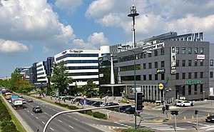
Służewiec
Neighbourhood of Warsaw, Poland
Distance: Approx. 204 meters
Latitude and longitude: 52.17972222,20.99388889
Służewiec is a neighbourhood, and an area of the City Information System, in the city of Warsaw, Poland, located within the district of Mokotów. Most of the neighbourhood consists of office buildings, which form one of the biggest complexes of office buildings in Poland, and one of the most important office centres in the city. It contains many headquarters of branches of many domestic and multinational corporations.

Warsaw Chopin Airport railway station
Railway station in Warsaw, Poland
Distance: Approx. 1773 meters
Latitude and longitude: 52.16963056,20.97521111
Warsaw Chopin Airport railway station (Polish: Warszawa Lotnisko Chopina) is the railway station of the Warsaw Chopin Airport in Warsaw, Poland. The station was built as part of a new Terminal 2 in 2008 but remained out of service until the rail link was completed in 2012. The cost of the 2 km (1.2 mi) link to Warszawa Służewiec was 230 million złoty.
Warszawa Żwirki i Wigury railway station
Railway station in Warsaw, Poland
Distance: Approx. 1520 meters
Latitude and longitude: 52.19305556,20.98111111
Warszawa Żwirki i Wigury railway station is a railway station in the Ochota district of Warsaw, Poland. It is served by Koleje Mazowieckie, who run services from Warszawa Wschodnia to Góra Kalwaria or Skarżysko-Kamienna.

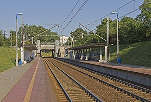
Warszawa Służewiec railway station
Railway station in Warsaw, Poland
Distance: Approx. 412 meters
Latitude and longitude: 52.18027778,20.98694444
Warszawa Służewiec is a railway stop in the city of Warsaw, Poland, on Marynarska Street, operated by the Polish State Railways. It is located at the railway line no. 8, which connects Warszawa Zachodnia (Warsaw West) and Kraków Główny (Kraków Main) railway stations.

Warszawa Okęcie railway station
Railway station in Warsaw, Poland
Distance: Approx. 1648 meters
Latitude and longitude: 52.16694444,20.9875
Warszawa Okęcie railway station is a railway station in the Ursynów district of Warsaw, Poland. It is served by Koleje Mazowieckie, which runs services from Warszawa Wschodnia to Góra Kalwaria and Skarżysko-Kamienna. There is also an unelectrified single track spur line branch (PKP rail line 937) linking the station to the Kabaty Depot of Warsaw Metro and the Siekierki Power Station.

Łazarski University
Distance: Approx. 1629 meters
Latitude and longitude: 52.1775,21.0157
Łazarski University (Polish: Uczelnia Łazarskiego; formerly known as Ryszard Łazarski Higher School of Commerce and Law In Warsaw) is a private Polish university located in Warsaw, founded by Ryszard Łazarski in 1993. The educational offer comprises studies at 3 faculties: the Faculty of Law and Administration, the Faculty of Economics and Management and the Faculty of Medicine. The university’s educational offer comprises BA studies, MA studies, doctoral studies in law, postgradual studies, MBA, LLM, doctoral seminars, trainings and language courses.

Zbarż Pond
Distance: Approx. 658 meters
Latitude and longitude: 52.18,20.98333333
Staw Zbarski is a small pond in Warsaw in the district of Włochy.
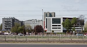
Mordor, Warsaw
Informal name for an area of Warsaw, Poland
Distance: Approx. 488 meters
Latitude and longitude: 52.18055556,20.99972222
Mordor, also known as Mordor on Domaniewska Street, is an informal name for the area, mostly composed of office buildings, in the city of Warsaw, Poland, located within the neighbourhoods of Służewiec (Służewiec Przemysłowy) and western Ksawerów in the district of Mokotów. It is located in the area around Cybernetyki, Domaniewska, Marynarska, and Wołoska Streets. The area is mostly composed of office buildings, including the headquarters of branches of many multinational corporations.

Nowy Służewiec
Neighbourhood in Warsaw, Masovian Voivodeship, Poland
Distance: Approx. 1321 meters
Latitude and longitude: 52.17083333,20.98388889
Nowy Służewiec, also known as Służewiec Nowy, is a neighbourhood of the city of Warsaw, Poland, located within the district of Włochy, within the City Information System area (neighbourhood) of Okęcie.
Weather in this IP's area
clear sky
19 Celsius
19 Celsius
17 Celsius
20 Celsius
1020 hPa
61 %
1020 hPa
1008 hPa
10000 meters
5.14 m/s
60 degree
06:12:35
18:49:14