Country:
 Poland
Region:
City:
Latitude and Longitude:
Time Zone:
Postal Code:
IP information under different IP Channel
ip-api
Country
Region
City
ASN
Time Zone
ISP
Blacklist
Proxy
Latitude
Longitude
Postal
Route
IPinfo
Country
Region
City
ASN
Time Zone
ISP
Blacklist
Proxy
Latitude
Longitude
Postal
Route
MaxMind
Country
Region
City
ASN
Time Zone
ISP
Blacklist
Proxy
Latitude
Longitude
Postal
Route
Luminati
Country
PLRegion
12
City
krakow
ASN
Time Zone
Europe/Warsaw
ISP
T-Mobile Polska S.A.
Latitude
Longitude
Postal
db-ip
Country
Region
City
ASN
Time Zone
ISP
Blacklist
Proxy
Latitude
Longitude
Postal
Route
ipdata
Country
Region
City
ASN
Time Zone
ISP
Blacklist
Proxy
Latitude
Longitude
Postal
Route
Popular places and events near this IP address
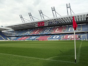
Henryk Reyman Municipal Stadium
Football stadium in Kraków, Poland
Distance: Approx. 2862 meters
Latitude and longitude: 50.06361111,19.91194444
Stadion Miejski im. Henryka Reymana (English: Henryk Reyman Municipal Stadium) is a football-specific stadium in Kraków, Poland. It is currently used as home ground by Wisła Kraków football team playing in the I liga matches.

Pedagogical University of Kraków
University in Kraków, Poland
Distance: Approx. 1893 meters
Latitude and longitude: 50.07346111,19.90876111
The University of National Education Comision (Polish: Uniwersytet Komisji Edukacji Narodowej w Krakowie, UKEN), is named after the Commission of National Education created by King Stanisław August Poniatowski. It is a public university located in Kraków, Poland. It was founded soon after the conclusion of World War II, on 11 May 1946, originally as the National Higher College of Teacher Training.

Prądnik Biały
Dzielnica of Kraków in Lesser Poland Voivodeship, Poland
Distance: Approx. 2071 meters
Latitude and longitude: 50.09923889,19.90630278
Prądnik Biały is one of 18 districts of Kraków, located in the northwest part of the city. The name Prądnik Biały comes from a village of same name that is now a part of the district. According to the Central Statistical Office data, the district's area is 23.42 square kilometres (9.04 square miles) and 69 135 people inhabit Prądnik Biały.

Krowodrza
Dzielnica of Kraków in Lesser Poland Voivodeship, Poland
Distance: Approx. 2822 meters
Latitude and longitude: 50.06666667,19.91666667
Krowodrza is one of 18 districts of Kraków, located in the western part of the city. The name Krowodrza comes from a village of same name that is now a part of the district. According to the Central Statistical Office data, the district's area is 5.62 square kilometres (2.17 square miles) and 31 870 people inhabit Krowodrza.
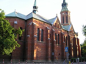
Church of the Holy Virgin Mary of Lourdes
Church in Kraków, Poland
Distance: Approx. 2291 meters
Latitude and longitude: 50.071,19.9128
The Church of the Holy Virgin Mary of Lourdes (Polish: Kościół Najświętszej Maryi Panny z Lourdes w Krakowie) is a Roman Catholic church in Kraków, Poland, dedicated to Our Lady of Lourdes. It was founded by the Lazarists, and built in 1892–1894 at ul. Misjonarska 37 street in the district of Krowodrza.

Museum of the History of Photography, Kraków
Distance: Approx. 2980 meters
Latitude and longitude: 50.070076,19.923744
The Walery Rzewuski Museum of the History of Photography in Kraków (Muzeum Historii Fotografii w Krakowie) is a state-run photography museum in Kraków, Poland, established as the only one of its kind a mere three years before the collapse of the Soviet empire. The venue survived the transition successfully owing to new programmes. The museum building is located on Józefitów 16 street in the Krowodrza district (north-west of Kleparz).
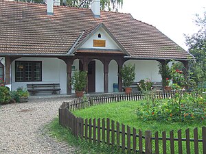
Rydlówka
Museum in Kraków, Poland
Distance: Approx. 837 meters
Latitude and longitude: 50.08777778,19.87805556
Regionalne Muzeum Młodej Polski "Rydlówka" is a museum in Kraków, Poland. It was constructed in 1894.

Miasteczko Studenckie AGH
Distance: Approx. 2180 meters
Latitude and longitude: 50.06833333,19.90583333
Miasteczko Studenckie AGH is the student campus of AGH University of Krakow and an osiedle in Kraków. It lies mostly between Reymonta, Tokarskiego, Nawojki and Miechowska streets. There are 8500 accommodations, for students of AGH (5400 places), and also students of Jagiellonian University, Pedagogical University of Cracow, Cracow University of Economics, Agricultural University of Cracow and other.

Kraków Mydlniki railway station
Railway station in Kraków, Poland
Distance: Approx. 2125 meters
Latitude and longitude: 50.0834,19.8589
Kraków Mydlniki is a railway station in the Bronowice district of Kraków, Poland, located in the neighbourhood of Mydlniki, northwest of the city centre. The station, with its historic building, lies within the Tenczynek Landscape Park (Tenczyński Park Krajobrazowy) protected area with numerous summer visitors, because the Park is also the location of a medieval Tenczyn Castle built as a seat of the powerful Tęczyński family. It fell into ruin during the Deluge in mid-17th century, after being pillaged and burned by Swedish-Brandenburgian forces looking for the Polish Crown Jewels and the rumored treasures of the Tęczyński family.
Embassy International School
International school in Krakow, Poland
Distance: Approx. 2878 meters
Latitude and longitude: 50.0729,19.9246
Embassy International School (Polish: Szkoła Międzynarodowa) is an international school in Kraków, Poland, offering A levels. It serves an age range of 3 to 18/19. Embassy International School offers education for the international and local community of all ages, from 3 to 19, from Nursery (Kindergarten) to the end of high school exams (A levels).
Bronowice, Kraków
Dzielnica of Kraków in Lesser Poland Voivodeship, Poland
Distance: Approx. 1572 meters
Latitude and longitude: 50.08333333,19.86666667
Bronowice is one of 18 districts of Kraków, located in the western part of the city. The name Bronowice comes from a village of same name that is now a part of the district. According to the Central Statistical Office data, the district's area is 9.56 square kilometres (3.69 square miles) and 24,014 people inhabit Bronowice.

Institute of Nuclear Physics of the Polish Academy of Sciences
Institute in Poland
Distance: Approx. 539 meters
Latitude and longitude: 50.08922222,19.89027778
The (Henryka Niewodniczański) Institute of Nuclear Physics Polish Academy of Sciences is a research center in the field of nuclear physics of the Polish Academy of Sciences, located in Kraków. It was founded in 1955 by Henryk Niewodniczański. In 1988 the institute was named after Niewodniczański.
Weather in this IP's area
clear sky
15 Celsius
15 Celsius
14 Celsius
16 Celsius
1018 hPa
77 %
1018 hPa
992 hPa
10000 meters
4.12 m/s
60 degree
06:18:11
18:52:28