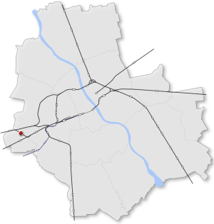
Country:
Region:
City:
Latitude and Longitude:
Time Zone:
Postal Code:
IP information under different IP Channel
ip-api
Country
Region
City
ASN
Time Zone
ISP
Blacklist
Proxy
Latitude
Longitude
Postal
Route
Luminati
Country
Region
14
City
warsaw
ASN
Time Zone
Europe/Warsaw
ISP
T-Mobile Polska S.A.
Latitude
Longitude
Postal
IPinfo
Country
Region
City
ASN
Time Zone
ISP
Blacklist
Proxy
Latitude
Longitude
Postal
Route
db-ip
Country
Region
City
ASN
Time Zone
ISP
Blacklist
Proxy
Latitude
Longitude
Postal
Route
ipdata
Country
Region
City
ASN
Time Zone
ISP
Blacklist
Proxy
Latitude
Longitude
Postal
Route
Popular places and events near this IP address

Battle of Białołęka
Distance: Approx. 358 meters
Latitude and longitude: 52.192881,20.889731
The Battle of Białołęka was fought from 24 to 25 February 1831 in the village of Białołęka, Poland, during the November Uprising. Though the Polish forces were victorious over the Russians, the outcome was not decisive, and was inconclusive in the scope of the larger Russo-Polish War.

Ursus, Warsaw
Warsaw District in Masovian Voivodeship, Poland
Distance: Approx. 355 meters
Latitude and longitude: 52.19277778,20.88972222
Ursus is a district (dzielnica) of Warsaw, one of the 18 such units into which the city is divided. Between 1952 and 1977 it was a separate city. Until 1954 it was known as Czechowice.

Włochy
Warsaw District in Masovian Voivodeship, Poland
Distance: Approx. 2354 meters
Latitude and longitude: 52.2,20.91666667
Włochy (Polish pronunciation: [ˈvwɔxɨ] ) is one of the districts of Warsaw, located in the south-western part of city. Włochy borders districts Bemowo and Wola from the north, Ochota and Mokotów from the east, and Ursus and Ursynów from the south. It is one of 3 neighborhoods with the title of a garden town (pol.
Gmina Michałowice, Masovian Voivodeship
Gmina in Masovian Voivodeship, Poland
Distance: Approx. 2473 meters
Latitude and longitude: 52.17,20.88333333
Gmina Michałowice is a rural gmina (administrative district) in Pruszków County, Masovian Voivodeship, in east-central Poland. Its seat is the village of Michałowice, which lies approximately 4 kilometres (2 mi) east of Pruszków and 11 km (6 mi) south-west of Warsaw. The gmina covers an area of 34.88 square kilometres (13.5 sq mi), and as of 2006 its total population is 15,529.
Michałowice, Pruszków County
Village in Masovian Voivodeship, Poland
Distance: Approx. 2473 meters
Latitude and longitude: 52.17,20.88333333
Michałowice [mixawɔˈvit͡sɛ] is a village in Pruszków County, Masovian Voivodeship, in east-central Poland. It is the seat of the gmina (administrative district) called Gmina Michałowice. It lies approximately 6 kilometres (4 mi) east of Pruszków and 10 km (6 mi) south-west of Warsaw.

Opacz-Kolonia
Village in Masovian Voivodeship, Poland
Distance: Approx. 2430 meters
Latitude and longitude: 52.17166667,20.89666667
Opacz Kolonia [ˈɔpat͡ʂ kɔˈlɔɲa] is a village in the administrative district of Gmina Michałowice, within Pruszków County, Masovian Voivodeship, in east-central Poland.

Warszawa Ursus railway station
Railway station in Warsaw, Poland
Distance: Approx. 435 meters
Latitude and longitude: 52.19611111,20.88472222
Warszawa Ursus railway station is a railway station in the Ursus district of Warsaw, Poland. The station is served by Koleje Mazowieckie, who run trains from Skierniewice to Warszawa Wschodnia, and Szybka Kolej Miejska, who run trains from Pruszków PKP to Otwock. The station was opened in 1926 as Ursus.

Piastów railway station
Railway station in Piastów, Poland
Distance: Approx. 1840 meters
Latitude and longitude: 52.19388889,20.85777778
Piastów railway station is a railway station in Piastów, Poland. The station is served by Koleje Mazowieckie, who run trains from Skierniewice to Warszawa Wschodnia, and Szybka Kolej Miejska, who run trains on line S1 from Pruszków PKP to Otwock.

Warszawa Ursus Północny railway station
Railway station in Warsaw, Poland
Distance: Approx. 1527 meters
Latitude and longitude: 52.20555556,20.88972222
Warszawa Ursus Północny railway station is a railway station in the Ursus district of Warsaw, Poland. The station is served by Koleje Mazowieckie, who run trains from Kutno to Warszawa Wschodnia.
Warszawa Gołąbki railway station
Railway station in Warsaw, Poland
Distance: Approx. 2321 meters
Latitude and longitude: 52.20805556,20.8625
Warszawa Gołąbki railway station is a railway station in the Ursus district of Warsaw, Poland. The station is served by Koleje Mazowieckie, who run trains from Kutno to Warszawa Wschodnia. The neighbourhood of Gołąbki (pl) was nominally a village in the present-day Warsaw West County.

Warszawa Ursus-Niedźwiadek railway station
Railway station in Warsaw, Poland
Distance: Approx. 1028 meters
Latitude and longitude: 52.19132,20.8696007
Warszawa Ursus–Niedźwiadek railway station is a railway station in the Ursus district of Warsaw, Poland. The station is served by Koleje Mazowieckie, which runs trains from Skierniewice to Warszawa Wschodnia, and Szybka Kolej Miejska, which runs trains from Pruszków PKP to Otwock.

Niedźwiadek, Warsaw
Neighbourhood of Warsaw, Poland
Distance: Approx. 1063 meters
Latitude and longitude: 52.19666667,20.87083333
Niedźwiadek is a residential neighbourhood built between 1968 and 1978 under the official name Spółdzielcze Osiedle Mieszkaniowe "Niedźwiadek"; since 2003, it also is the name of an area in City Information System. Both are part of Ursus district, Warsaw, Poland. The neighbourhood was built between 1968 and 1977, to provide housing to the employees of the nearby Ursus factory.
Weather in this IP's area
clear sky
7 Celsius
4 Celsius
6 Celsius
8 Celsius
1025 hPa
55 %
1025 hPa
1012 hPa
10000 meters
4.63 m/s
260 degree
06:35:52
16:04:06
