Country:
 France
Region:
City:
Latitude and Longitude:
Time Zone:
Postal Code:
IP information under different IP Channel
ip-api
Country
Region
City
ASN
Time Zone
ISP
Blacklist
Proxy
Latitude
Longitude
Postal
Route
IPinfo
Country
Region
City
ASN
Time Zone
ISP
Blacklist
Proxy
Latitude
Longitude
Postal
Route
MaxMind
Country
Region
City
ASN
Time Zone
ISP
Blacklist
Proxy
Latitude
Longitude
Postal
Route
Luminati
Country
FRASN
Time Zone
Europe/Paris
ISP
Alsatis SAS
Latitude
Longitude
Postal
db-ip
Country
Region
City
ASN
Time Zone
ISP
Blacklist
Proxy
Latitude
Longitude
Postal
Route
ipdata
Country
Region
City
ASN
Time Zone
ISP
Blacklist
Proxy
Latitude
Longitude
Postal
Route
Popular places and events near this IP address
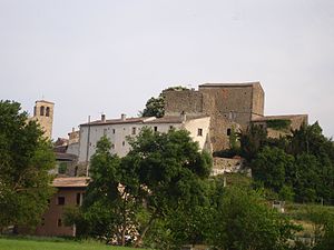
Château de Pieusse
Castle in Occitania
Distance: Approx. 2884 meters
Latitude and longitude: 43.08055556,2.23236111
The Château de Pieusse is one of the so-called Cathar castles in the French commune of Pieusse, near the town of Limoux in the département of l'Aude. It is a "true" Cathar castle in the sense that the site was never taken by the French crown during the annexation of Roussillon, but the buildings are mostly of more recent date. It is characterised by a keep, massive for the time, whose use was essentially defensive.
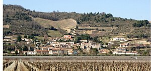
Cépie
Commune in Occitanie, France
Distance: Approx. 116 meters
Latitude and longitude: 43.1056,2.2453
Cépie (French pronunciation: [sepi] ; Occitan: Cépia) is a commune in the Aude department in southern France.
Gaja-et-Villedieu
Commune in Occitanie, France
Distance: Approx. 5235 meters
Latitude and longitude: 43.0822,2.1878
Gaja-et-Villedieu (French pronunciation: [gaʒa e vildjø] ; Occitan: Gajan e Viladieus) is a commune in the Aude department in southern France.
Malviès
Commune in Occitanie, France
Distance: Approx. 5053 meters
Latitude and longitude: 43.1197,2.1853
Malviès (French pronunciation: [malvjɛs] ; Occitan: Malvièrs) is a commune in the Aude department in southern France.
Pieusse
Commune in Occitanie, France
Distance: Approx. 2810 meters
Latitude and longitude: 43.081,2.2334
Pieusse (French pronunciation: [pjøs] ; Languedocien: Piussa) is a commune in the Aude department in southern France.

Pomas
Commune in Occitanie, France
Distance: Approx. 4043 meters
Latitude and longitude: 43.1125,2.2928
Pomas is a commune in the Aude department in Occitanie southern France. It is located 4 km northwest of Saint-Hilaire, 15 km south of Carcassonne, 100 km southeast of Toulouse.
Saint-Martin-de-Villereglan
Commune in Occitanie, France
Distance: Approx. 2628 meters
Latitude and longitude: 43.1069,2.2119
Saint-Martin-de-Villereglan (French pronunciation: [sɛ̃ maʁtɛ̃ də vilʁeglɑ̃] ; also Saint-Martin-de-Villeréglan; Occitan: Sant Martin de Vilareglan) is a commune in the Aude department in southern France.
Villarzel-du-Razès
Commune in Occitanie, France
Distance: Approx. 4903 meters
Latitude and longitude: 43.14,2.2075
Villarzel-du-Razès (French pronunciation: [vilaʁzɛl dy ʁazɛs] ; Languedocien: Vilarzèl de Rasés) is a commune in the Aude department in southern France.
Montclar, Aude
Commune in Occitanie, France
Distance: Approx. 3384 meters
Latitude and longitude: 43.1353,2.2475
Montclar (French pronunciation: [mɔ̃klaʁ] ) is a commune in the Aude department in southern France.

Jardin aux Plantes la Bouichère
Distance: Approx. 4340 meters
Latitude and longitude: 43.0692,2.223
The Jardin aux Plantes la Bouichère (2 hectares) is a private botanical garden specializing in fragrant plants. It is located on the banks of the river Aude in the Domaine de Flassian, Rue Dewoitine, Limoux, Aude, Languedoc-Roussillon, France, and open Wednesday through Sunday in the warmer months; an admission fee is charged. The garden was created circa 2001, and now contains some 2,500 perennials, shrubs, and trees, with a focus on aromatic plants, including 60 types of salvia and 30 types of mint.
Limoux-Flassian station
Railway station in Limoux, France
Distance: Approx. 4610 meters
Latitude and longitude: 43.06833333,2.21777778
Limoux-Flassian is a railway station in Limoux, Occitanie, France. The station is on the Carcassonne–Rivesaltes line. The station is served by TER (local) services operated by the SNCF. The station is just a single platform with a shelter, tickets need to be purchased on the train.

Pomas station
Railway station in Pomas, France
Distance: Approx. 3681 meters
Latitude and longitude: 43.11222222,2.28833333
Pomas is a railway station in Pomas, Occitanie, France. The station is on the Carcassonne–Rivesaltes line.
Weather in this IP's area
light rain
12 Celsius
12 Celsius
12 Celsius
12 Celsius
1017 hPa
91 %
1017 hPa
998 hPa
10000 meters
6.69 m/s
270 degree
75 %
08:08:22
19:03:31