85.208.100.245 - IP Lookup: Free IP Address Lookup, Postal Code Lookup, IP Location Lookup, IP ASN, Public IP
Country:
Region:
City:
Location:
Time Zone:
Postal Code:
ISP:
ASN:
language:
User-Agent:
Proxy IP:
Blacklist:
IP information under different IP Channel
ip-api
Country
Region
City
ASN
Time Zone
ISP
Blacklist
Proxy
Latitude
Longitude
Postal
Route
db-ip
Country
Region
City
ASN
Time Zone
ISP
Blacklist
Proxy
Latitude
Longitude
Postal
Route
IPinfo
Country
Region
City
ASN
Time Zone
ISP
Blacklist
Proxy
Latitude
Longitude
Postal
Route
IP2Location
85.208.100.245Country
Region
catalunya
City
canet de mar
Time Zone
Europe/Madrid
ISP
Language
User-Agent
Latitude
Longitude
Postal
ipdata
Country
Region
City
ASN
Time Zone
ISP
Blacklist
Proxy
Latitude
Longitude
Postal
Route
Popular places and events near this IP address

Arenys de Mar
Municipality in Catalonia, Spain
Distance: Approx. 2745 meters
Latitude and longitude: 41.58194444,2.55027778
Arenys de Mar (Catalan pronunciation: [əˈɾɛɲz ðə ˈmaɾ], locally [əˈɾɛɲʒ ðə ˈmaɾ], arenys being Catalan for "sands (of a seasonal creek)", and de mar for "by the sea" as opposed to Arenys de Munt, "sands up hill") is one of the main municipalities of the comarca of Maresme, Barcelona Province, Catalonia, Spain. It is situated on the coast between Caldes d'Estrac and Canet de Mar, about 40 kilometres (25 miles) northeast of Barcelona. As of 2022, it had a population of 16,155.

Arenys de Munt
Municipality in Catalonia, Spain
Distance: Approx. 4059 meters
Latitude and longitude: 41.61,2.54
Arenys de Munt (Catalan pronunciation: [əˈɾɛɲz ðə ˈmun], locally [əˈɾɛɲʒ ðə ˈmun], arenys being Catalan for "sands (of a seasonal creek)", and de munt for "up hill" as opposed to Arenys de Mar, "sands by the sea") is a municipality in the comarca of the Maresme in Catalonia, Spain. It is situated inland from the coast, in the el Corredor range and including the peak of el Montalt (595 m). It retains a textile industry specialised in the production of towels, and is also known for the production of strawberries, cherries and liqueurs.
Canet de Mar
Municipality in Catalonia, Spain
Distance: Approx. 817 meters
Latitude and longitude: 41.58333333,2.58333333
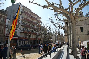
Canet de Mar (Catalan pronunciation: [kəˈnɛd də ˈmaɾ]) is a municipality in the comarca of the Maresme in Catalonia, Spain. It is situated on the coast between Arenys de Mar and Sant Pol de Mar. el Corredor and el Montnegre ranges.

Sant Cebrià de Vallalta
Municipality in Catalonia, Spain
Distance: Approx. 3789 meters
Latitude and longitude: 41.62111111,2.60111111
Sant Cebrià de Vallalta (Catalan pronunciation: [ˈsan səβɾiˈa ðə ˌβaʎˈaltə]) is a municipality in the comarca of the Maresme in Catalonia, Spain. It is situated inland from the coast, in the valley of the Sant Pol river below the Montnegre range. A local road links the town with Arenys de Munt and with Sant Pol de Mar.

C-32 highway (Spain)
Highway in Catalonia, Spain
Distance: Approx. 3948 meters
Latitude and longitude: 41.5825,2.535
C-32 is a primary highway in Catalonia, Spain. It was created in 2004 by merging three sections of existing autopistas and autovías. This re-organisation was part of a renaming of primary highways managed by the Generalitat de Catalunya.

Sant Pau (restaurant)
Distance: Approx. 3775 meters
Latitude and longitude: 41.6025,2.62361111
Sant Pau was a Spanish restaurant in Sant Pol de Mar, Catalonia (Spain), a town between Barcelona and Girona. In 2009 it was awarded three Michelin stars and three Campsa-Repsol suns. Its chef is Carme Ruscalleda, and the dining room was directed by Toni Balam.

Sant Pol de Mar bus crash
2009 motor vehicle incident in Spain
Distance: Approx. 2850 meters
Latitude and longitude: 41.60583333,2.60861111
The Sant Pol de Mar bus crash was a traffic accident which occurred on the evening of 30 July 2009 in Sant Pol de Mar, near Barcelona, in north-eastern Spain. A double-decker bus carrying Dutch tourists left the highway on a bend at the exit for the town, hit a car and a metal crash barrier and overturned. Six Dutch tourists were killed and between 36 and 44 people, including the driver, were injured, some seriously.

Arenys de Mar Museum
Museum in Arenys de Mar, Spain
Distance: Approx. 2856 meters
Latitude and longitude: 41.58197874,2.54884377
Arenys de Mar Museum (Catalan: Museu d'Arenys de Mar) is a museum in Arenys de Mar, Spain. It is made up of two different sections: the Marès Lace Museum and the Mollfulleda Mineralogy Museum, and it also conserves and exhibits the collection from the old Arenys de Mar Fidel Fita Municipal Museum.
Palau Foundation
Distance: Approx. 4966 meters
Latitude and longitude: 41.57106944,2.52751111
The Palau Foundation (Catalan: Fundació Palau) is an art exhibition centre in the centre of Caldes d'Estrac, in the region of El Maresme (Catalonia). It was opened in May 2003, to exhibit and disseminate the art collection that had been compiled by Josep Palau i Fabre, as well as its archives and library. Of particular importance is its archive and bibliographical collection on Pablo Picasso.
Lluís Domènech i Montaner House-Museum
Distance: Approx. 241 meters
Latitude and longitude: 41.58833611,2.58135278
The Lluís Domènech i Montaner House-Museum (Catalan: Casa Museu Lluís Domènech i Montaner), in Canet de Mar, in the region of El Maresme, is a space dedicated to the study of the life and works of architect Lluís Domènech i Montaner. The House-Museum includes the Domènech house, a work of the architect in collaboration with his son, Pere Domènech and his son-in-law, Francesc Guàrdia, and the 16th-century Can Rocosa farmhouse, which Domènech i Montaner converted into his workshop-study. The House-Museum is part of the Barcelona Provincial Council Local Museum Network.

Calella Lighthouse
Lighthouse in Catalonia, Spain
Distance: Approx. 5771 meters
Latitude and longitude: 41.608107,2.646399
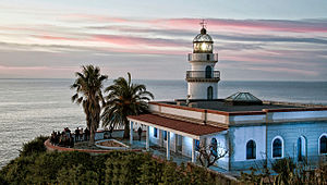
The Calella Lighthouse is an active lighthouse situated in the coastal town of Calella in Costa del Maresme, 58 km northeast of Barcelona, in Catalonia, Spain. Its construction began on 9 October 1856, and the engineer responsible for the project was Marià Parellada. The lighthouse was inaugurated on 15 December 1859.

Castle of Santa Florentina
11th-century castle in Catalonia, Spain
Distance: Approx. 1199 meters
Latitude and longitude: 41.6008,2.577
The Castle of Santa Florentina (Spanish: Castillo de Santa Florentina) is an 11th-century medieval castle in Canet de Mar, Catalonia, Spain. It was built on the foundations of an Ancient Roman villa by Guadimir de Canet (born 1024). In the 16th century, it passed into the hands of Dimas Muntaner.
Weather in this IP's area
clear sky
8 Celsius
8 Celsius
6 Celsius
10 Celsius
1027 hPa
55 %
1027 hPa
1008 hPa
10000 meters
0.91 m/s
0.79 m/s
345 degree
1 %


