Country:
 Switzerland
Region:
City:
Latitude and Longitude:
Time Zone:
Postal Code:
IP information under different IP Channel
ip-api
Country
Region
City
ASN
Time Zone
ISP
Blacklist
Proxy
Latitude
Longitude
Postal
Route
IPinfo
Country
Region
City
ASN
Time Zone
ISP
Blacklist
Proxy
Latitude
Longitude
Postal
Route
MaxMind
Country
Region
City
ASN
Time Zone
ISP
Blacklist
Proxy
Latitude
Longitude
Postal
Route
Luminati
Country
CHRegion
zh
City
zurich
ASN
Time Zone
Europe/Zurich
ISP
Init7 (Switzerland) Ltd.
Latitude
Longitude
Postal
db-ip
Country
Region
City
ASN
Time Zone
ISP
Blacklist
Proxy
Latitude
Longitude
Postal
Route
ipdata
Country
Region
City
ASN
Time Zone
ISP
Blacklist
Proxy
Latitude
Longitude
Postal
Route
Popular places and events near this IP address
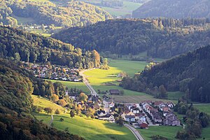
Stallikon
Municipality in Zurich, Switzerland
Distance: Approx. 2139 meters
Latitude and longitude: 47.33333333,8.48333333
Stallikon is a municipality in the district of Affoltern in the canton of Zürich in Switzerland.

Zimmerberg Base Tunnel
Railway tunnel in northeastern Switzerland
Distance: Approx. 1551 meters
Latitude and longitude: 47.3277,8.5312
The Zimmerberg Base Tunnel (ZBT) is a railway tunnel under the Zimmerberg mountains in Switzerland. Phase I of the tunnel was opened to traffic during April 2003. The ZBT has been divided into two phases of work; as of 2020, only Phase I is operational while Phase II remains in the planning and preparation stages.

District 2 (Zürich)
District in Zürich, Switzerland
Distance: Approx. 908 meters
Latitude and longitude: 47.337,8.521
District 2 is a district on the western side of Lake Zürich in the Swiss city of Zürich. The district comprises the quarters Wollishofen, Leimbach and Enge.

Wollishofen
Distance: Approx. 1936 meters
Latitude and longitude: 47.343944,8.530114
Wollishofen is a neighbourhood in Zürich's 2nd district, situated in the eastern foothills of Uetliberg. It was formerly a municipality of its own, having been incorporated into Zürich in 1893. The neighbourhood has a population of 15,592 distributed on an area of 5.75 km2.

Knabenschiessen
Swiss shooting competition in Zürich
Distance: Approx. 2205 meters
Latitude and longitude: 47.35166,8.50966
Knabenschiessen is a traditional target shooting competition in Zürich, held on the second weekend of September each year. The festival, officially held for the first time in 1889, is one of the oldest in Switzerland, dating back to the 17th century. The competition is open to 13- to 17-year-olds who either reside or are enrolled in a school in the canton of Zürich.

Leimbach (Zürich)
Distance: Approx. 379 meters
Latitude and longitude: 47.32863056,8.51299722
Leimbach (German: [ˈlaɪmbax] ) is a quarter in the district 2 in Zürich. It is located in the lower Sihl Valley (Sihltal). It was formerly a municipality of its own, having been incorporated into Zürich in 1893.
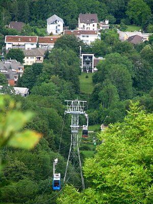
Adliswil-Felsenegg cable car
Distance: Approx. 2180 meters
Latitude and longitude: 47.31316667,8.52003333
The Adliswil-Felsenegg cable car (LAF; German: Luftseilbahn Adliswil-Felsenegg or Felseneggbahn) is a cable car in the canton of Zürich in Switzerland. The lower station is located in Adliswil in the Sihl Valley, whilst the upper station is located on the Felsenegg hill on the Albis ridge near the Felsenegg-Girstel TV-tower. The upper station at Felsenegg forms one end of a panoramic walk to the Uetliberg mountain, whilst the lower station is some 400 metres (1,300 ft) from Adliswil railway station.

Zürich Leimbach railway station
Railway station in the Leimbach quarter of the Swiss city of Zürich
Distance: Approx. 597 meters
Latitude and longitude: 47.3336,8.5191
Zürich Leimbach (German: Zürich Leimbach) is a railway station in the south-west of the Swiss city of Zürich, in the Leimbach quarter. The station is on the Sihltal line, which is operated by the Sihltal Zürich Uetliberg Bahn (SZU).

Manegg Castle
Distance: Approx. 563 meters
Latitude and longitude: 47.336879,8.51028
The ruins of the castle Manegg are situated on the eastern slopes of the Albis range in the canton of Zürich, near Leimbach.
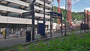
Zürich Manegg railway station
Railway station in the Swiss city of Zürich
Distance: Approx. 941 meters
Latitude and longitude: 47.338216,8.519881
Zürich Manegg (German: Zürich Manegg) is a railway station in the Swiss city of Zürich. The station is on the Sihltal line which is operated by the Sihltal Zürich Uetliberg Bahn (SZU).

Sood-Oberleimbach railway station
Railway station in north-east Switzerland
Distance: Approx. 1550 meters
Latitude and longitude: 47.319697,8.521501
Sood-Oberleimbach is a railway station in the Sihl Valley, and the municipality of Adliswil, in the Swiss Canton of Zürich. The station is on the Sihltal line, which is operated by the Sihltal Zürich Uetliberg Bahn (SZU).
Baldern Castle
Distance: Approx. 1964 meters
Latitude and longitude: 47.31470278,8.50577222
Baldern Castle (German: Burg Baldern or Burgstelle Baldern) is a former castle in the municipality of Stallikon and the canton of Zürich in Switzerland. The remains of the castle comprise a set of earthworks, situated on the Albis ridge at some 810 metres (2,660 ft) above sea level and about 4 kilometres (2.5 mi) south of the summit of Uetliberg. The earthworks are obscured by the site's woodland nature.
Weather in this IP's area
few clouds
19 Celsius
19 Celsius
17 Celsius
21 Celsius
1014 hPa
82 %
1014 hPa
957 hPa
10000 meters
3.09 m/s
330 degree
20 %
06:54:37
19:52:50