Country:
 Switzerland
Region:
City:
Latitude and Longitude:
Time Zone:
Postal Code:
IP information under different IP Channel
ip-api
Country
Region
City
ASN
Time Zone
ISP
Blacklist
Proxy
Latitude
Longitude
Postal
Route
IPinfo
Country
Region
City
ASN
Time Zone
ISP
Blacklist
Proxy
Latitude
Longitude
Postal
Route
MaxMind
Country
Region
City
ASN
Time Zone
ISP
Blacklist
Proxy
Latitude
Longitude
Postal
Route
Luminati
Country
CHRegion
ge
City
chatelaine
ASN
Time Zone
Europe/Zurich
ISP
Init7 (Switzerland) Ltd.
Latitude
Longitude
Postal
db-ip
Country
Region
City
ASN
Time Zone
ISP
Blacklist
Proxy
Latitude
Longitude
Postal
Route
ipdata
Country
Region
City
ASN
Time Zone
ISP
Blacklist
Proxy
Latitude
Longitude
Postal
Route
Popular places and events near this IP address
Vernier, Switzerland
Municipality in Geneva, Switzerland
Distance: Approx. 1776 meters
Latitude and longitude: 46.2,6.1
Vernier (French pronunciation: [vɛʁ.nje]) is a municipality in the Canton of Geneva, in Switzerland.

Arve
River in France
Distance: Approx. 1823 meters
Latitude and longitude: 46.20129,6.12197
The Arve (French: L'Arve, French pronunciation: [aʁv]) is a river in France (département of Haute-Savoie), and Switzerland (canton of Geneva). A left tributary of the Rhône, it is 108 km (67 mi) long, of which 9 km in Switzerland. Its catchment area is 1,976 km2 (763 sq mi), of which 80 km2 in Switzerland.

Servette
District in Geneva, Switzerland
Distance: Approx. 1749 meters
Latitude and longitude: 46.21212,6.13097
Servette is a district of the city of Geneva, Switzerland. The district's name comes from the Latin word for forest, silva, and means "little forest". Its name alludes to Servette's rural past, before Geneva grew beyond its walls and incorporated the area.
International University in Geneva
Distance: Approx. 1180 meters
Latitude and longitude: 46.224,6.101
The International Institute in Geneva (IIG) -- formerly known as International University in Geneva - IUN or IUG), founded in 1997, is a private business school in Geneva, Switzerland. The business school is located in the International Centre Cointrin, next to Geneva Airport.

Charmilles Stadium
Distance: Approx. 974 meters
Latitude and longitude: 46.2091,6.1182
Charmilles Stadium was a multi-purpose stadium in Geneva, Switzerland. It was used mostly for football matches, and was the home venue for Servette FC. The stadium was able to hold 9,250 people and was built in 1930 for the Coupe des Nations 1930 tournament. During the 1954 FIFA World Cup the stadium hosted four games.

Geneva Mosque
Mosque in Geneva, Switzerland
Distance: Approx. 1421 meters
Latitude and longitude: 46.22361111,6.12194444
The Geneva Mosque, also known as the Petit-Saconnex Mosque (French: Mosquée de Genève, Mosquée de Petit-Sacconex) is the largest mosque in Geneva, Switzerland. It was financed by the Saudi-based Muslim World League and constructed in 1978 in the neighborhood of Le Petit-Saconnex. The mosque was inaugurated by the Saudi Arabian King Khalid ibn Abd al-Aziz and President of the Swiss Confederation Willi Ritschard, and is the largest mosque in the city and Switzerland as a whole.

Aïre
Distance: Approx. 1844 meters
Latitude and longitude: 46.19888889,6.10194444
Aïre is a small locality in the Canton of Geneva. It is on the North bank of the river Rhone. It is near Le Lignon, a 1km long block of flats.

United Nations Office on Sport for Development and Peace
Distance: Approx. 1515 meters
Latitude and longitude: 46.2283824,6.1097541
The United Nations Office on Sport for Development and Peace (UNOSDP) was introduced by Kofi Annan in 2001. Its mandate was to coordinate the efforts undertaken by the United Nations in promoting sport in a systematic and coherent way as a means to contribute to the achievement of development and peace. The second UN Special Adviser on Sport for Development and Peace was Wilfried Lemke from Bremen, Germany.

Deutsche Schule Genf
School in Switzerland
Distance: Approx. 1669 meters
Latitude and longitude: 46.2182,6.0875
Deutsche Schule Genf (DSG; French: École Allemande de Genève) is a German international school in Vernier, Switzerland, in the Geneva metropolitan area. It serves levels Kindergarten through Sekundarstufe II (Oberstufe).
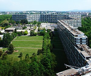
Le Lignon
Urban development in Vernier, Geneva, Switzerland
Distance: Approx. 1545 meters
Latitude and longitude: 46.2031,6.0978
Le Lignon is an urban development in the town of Vernier, canton of Geneva, Switzerland. It was built by architect George Addor between 1964 and 1966 and consists of three large buildings and is one of the largest apartment complexes in the world, containing 2,780 units. It is located on former farmland and was built to address a housing shortage in the 1960s and early 1970s.
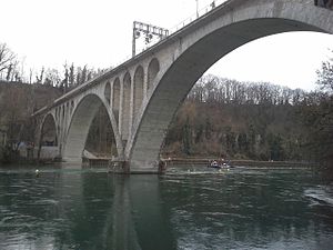
Viaduc de la Jonction
Swiss Viaduct
Distance: Approx. 1786 meters
Latitude and longitude: 46.2012,6.1209
The Viaduc de la Jonction (Viaduct of the Junction) is a rail viaduct in Geneva, Switzerland. It was completed in 1945. It is located above the confluence of the rivers Rhône & Arve, locally known as "la Jonction" (the Junction), from which it gets its name.

Vernier railway station
Railway station in Vernier, Switzerland
Distance: Approx. 1311 meters
Latitude and longitude: 46.22071889,6.09389194
Vernier railway station (French: Gare de Vernier), formerly known as Cointrin, is a railway station in the municipality of Vernier, in the Swiss canton of Geneva. It is an intermediate stop on the standard gauge Lyon–Geneva line of Swiss Federal Railways.
Weather in this IP's area
overcast clouds
18 Celsius
18 Celsius
17 Celsius
19 Celsius
1014 hPa
76 %
1014 hPa
965 hPa
10000 meters
1.03 m/s
100 %
07:05:16
20:01:24