Country:
 Netherlands
Region:
City:
Latitude and Longitude:
Time Zone:
Postal Code:
IP information under different IP Channel
ip-api
Country
Region
City
ASN
Time Zone
ISP
Blacklist
Proxy
Latitude
Longitude
Postal
Route
IPinfo
Country
Region
City
ASN
Time Zone
ISP
Blacklist
Proxy
Latitude
Longitude
Postal
Route
MaxMind
Country
Region
City
ASN
Time Zone
ISP
Blacklist
Proxy
Latitude
Longitude
Postal
Route
Luminati
Country
NLRegion
nb
City
vught
ASN
Time Zone
Europe/Amsterdam
ISP
LeaseWeb Netherlands B.V.
Latitude
Longitude
Postal
db-ip
Country
Region
City
ASN
Time Zone
ISP
Blacklist
Proxy
Latitude
Longitude
Postal
Route
ipdata
Country
Region
City
ASN
Time Zone
ISP
Blacklist
Proxy
Latitude
Longitude
Postal
Route
Popular places and events near this IP address
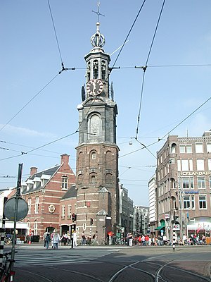
Munttoren
Distance: Approx. 86 meters
Latitude and longitude: 52.36694444,4.89333333
The Munttoren (Dutch pronunciation: [ˈmʏnˌtoːrə(n)]; "Mint Tower") or Munt ([mʏnt]) is a tower in Amsterdam, Netherlands. It stands on the busy Muntplein square, where the Amstel river and the Singel canal meet, near the flower market and the eastern end of the Kalverstraat shopping street.

Rembrandtplein
Square in Amsterdam, Netherlands
Distance: Approx. 159 meters
Latitude and longitude: 52.36611111,4.89666667
Rembrandtplein (English: Rembrandt Square) is a major square in central Amsterdam, Netherlands, named after Rembrandt van Rijn who owned a house nearby from 1639 to 1656.

De Kleine Komedie
Theatre in Amsterdam, Netherlands
Distance: Approx. 107 meters
Latitude and longitude: 52.36680556,4.89611111
De Kleine Komedie is today the oldest theatre in Amsterdam, dating from 1788. Situated on the Amstel near the Halvemaansteeg, the building offers a stage for both upcoming and established Dutch talents. The theatre has 503 seats.
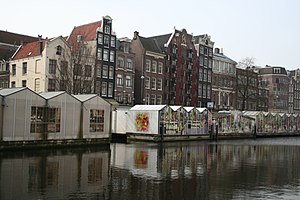
Bloemenmarkt
Flower market in Amsterdam
Distance: Approx. 176 meters
Latitude and longitude: 52.36666667,4.89194444
The Bloemenmarkt (Dutch pronunciation: [ˈbluməˌmɑr(ə)kt]) is the world's only floating flower market. Founded in 1862, it is sited in Amsterdam, Netherlands, on the Singel canal between Muntplein and Koningsplein in the city's southern canal belt. It has 15 souvenir and gift shops, with only a few still selling fresh flowers.
Muntplein, Amsterdam
Square in Amsterdam, Netherlands
Distance: Approx. 86 meters
Latitude and longitude: 52.36694444,4.89333333
The Muntplein (Mint Square) is a square in the centre of Amsterdam. The square is in fact a bridge — the widest bridge in Amsterdam — that crosses the Singel canal at the point where it flows into the Amstel river. All bridges in Amsterdam are numbered, and the Muntplein carries the number 1.

Museum of Bags and Purses
Fashion Museum in Amsterdam, Netherlands
Distance: Approx. 174 meters
Latitude and longitude: 52.365938,4.896782
The Museum of Bags and Purses (Dutch: Tassenmuseum Amsterdam), was a museum devoted to the history of bags, purses, and their related accessories. Located in Amsterdam's historic central canal belt, the museum's collection included over 5,000 items dating back to the sixteenth-century. One of only three museums across the globe specialising in this field, it housed the world's largest collection of bags and purses.

De L'Europe Amsterdam
Luxury hotel
Distance: Approx. 89 meters
Latitude and longitude: 52.3675,4.89444444
De L'Europe Amsterdam (formerly known as Hotel de l'Europe) is a five-star hotel located on the Amstel river in the centre of Amsterdam, Netherlands. De L'Europe Amsterdam is situated opposite and overlooking the Munt, where the river Amstel flows into the Rokin canal. The 19th-century hotel became an official monument (rijksmonument) in 2001.

Vijzelstraat 31
Distance: Approx. 95 meters
Latitude and longitude: 52.36625833,4.89333611
Vijzelstraat 31 in Amsterdam, The Netherlands, is a historical establishment, probably dating from the 17th century. It has a gable roof from the first half of the 18th century. The building is currently used as a shop, together with the adjacent buildings (numbers 27 to 35) by Aurora, a supplier of electrical and electronic products.

Excelsior (restaurant)
Restaurant in Amsterdam, Netherlands
Distance: Approx. 92 meters
Latitude and longitude: 52.36747778,4.8941
Excelsior is a defunct restaurant located in Hotel de l'Europe, Amsterdam, Netherlands. It was a fine dining restaurant that was awarded one Michelin stars for the period 1957-1970 and for the period 1987–1992. Restaurant Excelsior closed in 2010 and was replaced by "Restaurant Bord'Eau" in February 2011.

Atria Institute on gender equality and women's history
Distance: Approx. 141 meters
Latitude and longitude: 52.36579,4.8931
Atria, institute on gender equality and women's history is a public library and research institute in Amsterdam dedicated to research and policy advice on gender equality and to the documentation and archival of women's history. Its previous names were International Information Centre and Archive for the Women's Movement (IIAV) (1988-2009) and Aletta, Institute for Women's History (2009-2013).

Kloveniersdoelen, Amsterdam
Civic guard complex in Amsterdam
Distance: Approx. 138 meters
Latitude and longitude: 52.36777778,4.89555556
The Kloveniersdoelen ("musketeers' shooting range") was a complex of buildings in Amsterdam which served as headquarters and shooting range for the local schutterij (civic guard). The companies of kloveniers were armed with an early type of musket known as an arquebus, known in Dutch as a bus, haakbus or klover (from the French couleuvrine), hence the name kloveniers. The Kloveniersdoelen was located at the corner of Nieuwe Doelenstraat and Kloveniersburgwal canal, both named after the former shooting range.

Doelen Hotel
Distance: Approx. 188 meters
Latitude and longitude: 52.3682,4.8958
Tivoli Doelen Amsterdam Hotel is a historic hotel in the Binnenstad (historic centre) of Amsterdam, the oldest hotel in the city. It is located on the Binnen-Amstel (inner Amstel) at the southern end of the Kloveniersburgwal. The entrance is at Nieuwe Doelenstraat 24.
Weather in this IP's area
drizzle rain
15 Celsius
15 Celsius
14 Celsius
17 Celsius
1015 hPa
89 %
1015 hPa
1015 hPa
3500 meters
10.29 m/s
250 degree
75 %
08:14:52
18:35:07