Country:
 France
Region:
City:
Latitude and Longitude:
Time Zone:
Postal Code:
IP information under different IP Channel
ip-api
Country
Region
City
ASN
Time Zone
ISP
Blacklist
Proxy
Latitude
Longitude
Postal
Route
IPinfo
Country
Region
City
ASN
Time Zone
ISP
Blacklist
Proxy
Latitude
Longitude
Postal
Route
MaxMind
Country
Region
City
ASN
Time Zone
ISP
Blacklist
Proxy
Latitude
Longitude
Postal
Route
Luminati
Country
FRRegion
naq
City
larochelle
ASN
Time Zone
Europe/Paris
ISP
Groupe Telecoms De L Ouest SAS
Latitude
Longitude
Postal
db-ip
Country
Region
City
ASN
Time Zone
ISP
Blacklist
Proxy
Latitude
Longitude
Postal
Route
ipdata
Country
Region
City
ASN
Time Zone
ISP
Blacklist
Proxy
Latitude
Longitude
Postal
Route
Popular places and events near this IP address

Arrondissement of La Rochelle
Arrondissement in Nouvelle-Aquitaine, France
Distance: Approx. 2901 meters
Latitude and longitude: 46.16666667,-1.16666667
The Arrondissement of La Rochelle (French: arrondissement de La Rochelle) is an arrondissement of France, located in the Charente-Maritime department, region of Nouvelle-Aquitaine. It has 58 communes. Its population is 215,707 (2016), and its area is 852.8 km2 (329.3 sq mi).

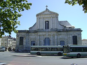
La Rochelle Cathedral
Catholic church in France
Distance: Approx. 4040 meters
Latitude and longitude: 46.16138889,-1.15333333
La Rochelle Cathedral (French: Cathédrale Saint-Louis de la Rochelle) is a Catholic church located in the city of La Rochelle, France. The cathedral has been a national monument since 1906.

La Pallice
Port in La Rochelle, France
Distance: Approx. 2377 meters
Latitude and longitude: 46.15833333,-1.22777778
La Pallice (also known as grand port maritime de La Rochelle) is the commercial deep-water port of La Rochelle, France. During the Fall of France, on 19 June 1940, approximately 6,000 Polish soldiers in exile under the command of Stanisław Sosabowski arrived at La Pallice, from where they were evacuated to Great Britain - thus able to go on fighting till the end of the war. Under the Nazi Occupation of France, La Pallice was used as a U-boat base (Base sous-marine de La Rochelle) from October 1941 when the 3rd U-boat Flotilla was moved there from its base in Kiel.
Roman Catholic Diocese of La Rochelle and Saintes
Catholic diocese in France
Distance: Approx. 4087 meters
Latitude and longitude: 46.15611111,-1.15555556
The Diocese of La Rochelle and Saintes (Latin: Dioecesis Rupellensis et Santonensis; French: Diocèse de La Rochelle et Saintes) is a Latin Church diocese of the Catholic Church in France. The diocese comprises the département of Charente-Maritime and the French overseas collectivity of Saint-Pierre and Miquelon. The bishop is a suffragan of the Archbishop of Poitiers.

L'Houmeau
Commune in Nouvelle-Aquitaine, France
Distance: Approx. 2826 meters
Latitude and longitude: 46.1939,-1.1861
L'Houmeau (French pronunciation: [lumo]) is a commune in the Charente-Maritime department in southwestern France.

Vauclair Castle
Distance: Approx. 3986 meters
Latitude and longitude: 46.1625,-1.15361111
Vauclair Castle, also Vauclerc Castle (French: 'Château Vauclair) was a castle built in La Rochelle, on the Atlantic coast of France, by Henry II of England in the 12th century. The castle was located in the area defined by the current Place de Verdun (formally called Place du Château). It was incorporated in the fortifications of the city built by William X of Aquitaine, father of Queen Eleanor of Aquitaine, in 1130.

Orbigny-Bernon Museum
Distance: Approx. 3915 meters
Latitude and longitude: 46.16083333,-1.15527778
The Orbigny-Bernon Museum (French: Musée d'Orbigny-Bernon, [myze dɔʁbiɲi bɛʁnɔ̃]) is a history museum in the French city of La Rochelle. It was founded in 1917, and contains collections relating to the history of La Rochelle, as well as an important collection of porcelains of the city. A floor is also dedicated to Far Eastern art, with the collection of the French diplomat Baron Charles de Chassiron.

Fort Louis (La Rochelle)
Distance: Approx. 3000 meters
Latitude and longitude: 46.1558,-1.1721
Fort Louis was a Royal fort built just outside the walls of the Huguenot city in La Rochelle. The fort was a source of great tension between the Huguenots of La Rochelle and Louis XIII, and was perceived as a real threat to their survival. Marshal Lesdiguieres predicted "Either La Rochelle must take Fort Louis, or the Fort will destroy La Rochelle." The construction of the fort had been started by the Count of Soissons in 1620 during the first Huguenot rebellion.

Muséum d'Histoire naturelle de La Rochelle
Distance: Approx. 4119 meters
Latitude and longitude: 46.1648,-1.1511
The Muséum d'histoire naturelle de La Rochelle is a natural history museum located in the city of La Rochelle, France. The building is listed as a historic monument by order of October 27, 2003. He is a member of the national network of naturalist collections (RECOLNAT).

Stade Marcel-Deflandre
Sports stadium in La Rochelle, France
Distance: Approx. 2482 meters
Latitude and longitude: 46.15805556,-1.17805556
Stade Marcel-Deflandre is a sports stadium in La Rochelle, France. It was built by Emile Sourice. It is the home ground of rugby union team Stade Rochelais of the Top 14 who have played there since it was opened in 1926.

Île de Ré bridge
Bridge in Charente-Maritime, France
Distance: Approx. 2740 meters
Latitude and longitude: 46.17166667,-1.23916667
The Île de Ré bridge is located in French departement of Charente-Maritime, on the western coast of France and connects the mainland (La Rochelle) to the Île de Ré via a 2,926.5-meter-long curve, culminating at 42 meters above sea level. Built by Bouygues and financed by the Charente-Maritime, the bridge was opened to traffic on 19 May 1988. It is the second longest bridge in France, behind the Saint-Nazaire Bridge (1975) and ahead of the Ile d'Oléron Bridge.
Canton of Lagord
Distance: Approx. 3937 meters
Latitude and longitude: 46.19,-1.16
The canton of Lagord is an administrative division of the Charente-Maritime department, western France. It was created at the French canton reorganisation which came into effect in March 2015. Its seat is in Lagord.
Weather in this IP's area
overcast clouds
12 Celsius
12 Celsius
12 Celsius
12 Celsius
1019 hPa
100 %
1019 hPa
1018 hPa
10000 meters
5.14 m/s
330 degree
100 %
08:26:09
19:13:20