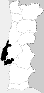
Country:
 Portugal
Region:
City:
Latitude and Longitude:
Time Zone:
Postal Code:
IP information under different IP Channel
ip-api
Country
Region
City
ASN
Time Zone
ISP
Blacklist
Proxy
Latitude
Longitude
Postal
Route
IPinfo
Country
Region
City
ASN
Time Zone
ISP
Blacklist
Proxy
Latitude
Longitude
Postal
Route
MaxMind
Country
Region
City
ASN
Time Zone
ISP
Blacklist
Proxy
Latitude
Longitude
Postal
Route
Luminati
Country
PTRegion
11
City
cascais
ASN
Time Zone
Europe/Lisbon
ISP
Nos Comunicacoes, S.A.
Latitude
Longitude
Postal
db-ip
Country
Region
City
ASN
Time Zone
ISP
Blacklist
Proxy
Latitude
Longitude
Postal
Route
ipdata
Country
Region
City
ASN
Time Zone
ISP
Blacklist
Proxy
Latitude
Longitude
Postal
Route
Popular places and events near this IP address

Boca do Inferno
Tourist attraction in Cascais, Portugal
Distance: Approx. 3003 meters
Latitude and longitude: 38.69111111,-9.43111111
Boca do Inferno (Portuguese for Hell's Mouth) is a chasm located in the seaside cliffs close to the Portuguese city of Cascais, in the District of Lisbon. The seawater has access to the deep bottom of the chasm and vigorously strikes its rocky walls, making it a popular tourist attraction. The cave was the first to be depicted in moving pictures, in the 1896 British film A Sea Cave Near Lisbon, which shows waves breaking at the mouth of the cave.

Praia do Guincho
Beach in Portugal
Distance: Approx. 2933 meters
Latitude and longitude: 38.733149,-9.472696
Praia do Guincho (English: Guincho Beach) is an Atlantic beach located on Portugal's Estoril coast, 5 km from the town of Cascais, and is located in the municipality of Cascais, more precisely in the parishes of Cascais e Estoril and Alcabideche, in the District of Lisbon. Guincho is situated close to several small villages, including Areia, Charneca, Figueira do Guincho and Biscaia. The beach, which has a shoreline of approximately 800 metres, has preferred surfing conditions and is popular for surfing, windsurfing, and kitesurfing.
Lisboa VR
Distance: Approx. 750 meters
Latitude and longitude: 38.7150166,-9.4477633
Lisboa, until 2009 named Estremadura, is a Portuguese wine region covering the same areas as the Estremadura region, and taking its name from the country's capital. The region is classified as a Vinho Regional (VR), a designation similar to a French vin de pays region. While the Beiras and Alentejo VRs are largest geographically, the Lisboa region is Portugal's largest producer of wine by volume.

Roman ruins of Casais Velhos
Distance: Approx. 1886 meters
Latitude and longitude: 38.72611111,-9.46416667
The Roman ruins of Casais Velhos are the remains of a Roman town, in the municipality of Cascais, Lisbon District, Portugal that included baths, two cemeteries, remains of a wall and ceramic artifacts.
Roman villa of Vilares
Distance: Approx. 2362 meters
Latitude and longitude: 38.73038333,-9.44383611
The Roman ruins of Vilares (Portuguese: Ruinas romanas de Vilares) is an archaeological excavation in the civil parish of Alcabideche, municipality of Cascais, discovered in the early part of the 21st century on a site designated for residential development. The site identified remnants that implied a necropolis and remains of a Roman villa (imbrices and terra sigillata), but suggested occupation since the Iron Age until Moorish intervention.

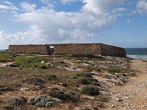
Cabo Raso Lighthouse
Lighthouse in Portugal
Distance: Approx. 2718 meters
Latitude and longitude: 38.70944444,-9.48583333
Cabo Raso Lighthouse is an active Portuguese lighthouse that is located in the Fort of São Brás of Sanxete, near Cascais, Lisbon District. It is a cylindrical, red, metallic tower, thirteen meters high, with a lantern and balcony and attached buildings.

Museum of the Sea, Cascais
Maritime and fishing museum in Portugal
Distance: Approx. 3116 meters
Latitude and longitude: 38.6952,-9.4249
The King D. Carlos Sea Museum (Portuguese: Museu do Mar Rei D. Carlos) is a Maritime Museum in the fishing town of Cascais, Lisbon District, in Portugal. It was inaugurated in 1992.
Fort of Cresmina
Building in Cascais, Lisbon District, Portugal
Distance: Approx. 2449 meters
Latitude and longitude: 38.72277778,-9.47833333
The Fort of Cresmina (Portuguese: Forte da Cresmina), also known as the Fort of Crismina, is located at the southern end of Cresmina beach, in the municipality of Cascais, Lisbon District, in Portugal. Originally built in 1762 to protect Cresmina beach from landings, it was transferred to private ownership in 1889. As of 2021 it was in the process of being converted into a restaurant.

Fort of Nossa Senhora da Guia (Cascais)
Building in Cascais, Lisbon District, Portugal
Distance: Approx. 1749 meters
Latitude and longitude: 38.69527778,-9.4525
The Fort of Nossa Senhora da Guia is located in Cascais, Lisbon District in Portugal. It was built during the Portuguese Restoration War (1640-1668), becoming operational in 1646. The site, which preserves some parts of the fort, is now occupied by a maritime laboratory under control of the Faculty of Sciences of the University of Lisbon.
Cabo Raso
Cape in western coastal Portugal
Distance: Approx. 2646 meters
Latitude and longitude: 38.70933333,-9.485
Cabo Raso (Cape Raso) is a cape along the coast of Cascais in western coastal Portugal.

Fort São Brás de Sanxete
Distance: Approx. 2718 meters
Latitude and longitude: 38.70944444,-9.48583333
Fort São Brás de Sanxete (Forte de São Brás de Sanxete in Portuguese) is located in Cabo Raso, parish and municipality of Cascais, district of Lisbon, in Portugal.

Avner Cohen Casa Chabad
Jewish community centre in Portugal
Distance: Approx. 1606 meters
Latitude and longitude: 38.6996,-9.4431
The Avner Cohen Casa Chabad (Avner Cohen Chabad House) is a Jewish community centre situated in Cascais in the Lisbon District of Portugal. It includes a library that places special emphasis on works about the Torah, either those written by Portuguese Jewish scholars or printed in Portugal in the late 15th century.
Weather in this IP's area
scattered clouds
19 Celsius
20 Celsius
18 Celsius
20 Celsius
1019 hPa
79 %
1019 hPa
1011 hPa
10000 meters
4.02 m/s
8.05 m/s
41 degree
34 %
07:32:54
19:22:20