Country:
 Portugal
Region:
City:
Latitude and Longitude:
Time Zone:
Postal Code:
IP information under different IP Channel
ip-api
Country
Region
City
ASN
Time Zone
ISP
Blacklist
Proxy
Latitude
Longitude
Postal
Route
IPinfo
Country
Region
City
ASN
Time Zone
ISP
Blacklist
Proxy
Latitude
Longitude
Postal
Route
MaxMind
Country
Region
City
ASN
Time Zone
ISP
Blacklist
Proxy
Latitude
Longitude
Postal
Route
Luminati
Country
PTRegion
11
City
amadora
ASN
Time Zone
Europe/Lisbon
ISP
Nos Comunicacoes, S.A.
Latitude
Longitude
Postal
db-ip
Country
Region
City
ASN
Time Zone
ISP
Blacklist
Proxy
Latitude
Longitude
Postal
Route
ipdata
Country
Region
City
ASN
Time Zone
ISP
Blacklist
Proxy
Latitude
Longitude
Postal
Route
Popular places and events near this IP address
Parede
Civil parish in Lisbon, Portugal
Distance: Approx. 2767 meters
Latitude and longitude: 38.69333333,-9.35694444
Parede (Portuguese pronunciation: [ˈvilɐ ðɐ pɐˈɾeðɨ]) is a former civil parish in the municipality of Cascais, Portugal. In 2013, the parish merged into the new parish Carcavelos e Parede. In 2001 its resident population was approximately 17,830 inhabitants, covering an area of 3.6 km2, west of Lisbon on the coast near the mouth of the Tagus estuary.

São Domingos de Rana
Civil parish in Lisbon, Portugal
Distance: Approx. 2181 meters
Latitude and longitude: 38.702,-9.34
São Domingos de Rana (Portuguese pronunciation: [sɐ̃w duˈmĩɡuʒ ðɨ ˈʁɐnɐ]) is a civil parish (Portuguese: freguesia) of the Portuguese municipality of Cascais, part of the Greater Lisbon subregion. The population in 2011 was 57,502, in an area of 20.36 km2. The parish includes the localities Abóboda, Cabeço de Mouro, Caparide, Matarraque, Outeiro de Polima, Polima, Rana, Talaíde, Tires, Trajouce and Zambujal.

Cascais Municipal Aerodrome
Airport in São Domingos de Rana, Portugal
Distance: Approx. 834 meters
Latitude and longitude: 38.72555556,-9.35527778
Lisbon Cascais-Tejo Regional Airport (Cascais Municipal Aerodrome), also known as Tires Aerodrome (Portuguese: Aeródromo de Tires/Aeródromo Municipal de Cascais) (IATA: CAT, ICAO: LPCS) is a regional airport, situated near the village of Tires, in the civil parish of São Domingos de Rana, in the Portuguese municipality of Cascais, approximately 12 km (7.5 mi) northeast of town of the same name in the Greater Lisbon subregion.
St. Dominic's International School
School in São Domingos de Rana, Cascais, Portugal
Distance: Approx. 2254 meters
Latitude and longitude: 38.71305556,-9.32916667
St. Dominics International School is a school in São Domingos de Rana, Cascais, near Lisbon, in Portugal. It was founded by Irish Dominican Sisters, beginning as the Bom Sucesso Girls Day School in 1954.

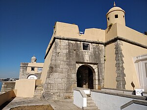
Fort of São Pedro do Estoril
Distance: Approx. 3819 meters
Latitude and longitude: 38.70225556,-9.39328889
The Fort of São Pedro do Estoril, also known as the Fort of Poça, is a medieval fortification, along the coast of the civil parish of Estoril, in the municipality of Cascais. Situated on the beach of Poça, the Fort was part of a group of fortifications during the Joanino era of Portuguese monarchs, built between 1642 and 1648 to form a defensive line between the Fort of São Julião da Barra and Cabo da Roca.
Roman villa of Outeiro de Polima
Distance: Approx. 2238 meters
Latitude and longitude: 38.71602778,-9.32866667
The Roman villa of Outeiro de Polima (Portuguese: Villa Romana de Outeiro de Polima) is a Roman villa in the civil parish of São Domingos de Rana, in the Portuguese municipality of Cascais, dating from the 1st to 6th centuries AD.
Carcavelos e Parede
Civil parish in Lisbon, Portugal
Distance: Approx. 3494 meters
Latitude and longitude: 38.691,-9.334
Carcavelos e Parede is a civil parish in the municipality of Cascais, Portugal. It was formed in 2013 by the merger of the former parishes Carcavelos and Parede. The population in 2011 was 45,007, in an area of 8.11 km2.
Tires, Portugal
Distance: Approx. 406 meters
Latitude and longitude: 38.71666667,-9.35
Tires is a Portuguese village located in the civil parish of São Domingos de Rana, in the coastal municipality of Cascais.

Roman villa of Freiria
Distance: Approx. 2719 meters
Latitude and longitude: 38.72105556,-9.32322222
The Roman villa of Freiria (Portuguese: Villa Romana de Freiria) is a Roman villa in the civil parish of São Domingos de Rana, in the Portuguese municipality of Cascais.
Colégio Marista de Carcavelos
Parochial school in Lisbon, Portugal, Portugal, Portugal
Distance: Approx. 3002 meters
Latitude and longitude: 38.69225556,-9.34445
Colégio Marista de Carcavelos is a school founded by Henrique Garcia in Lisbon, Portugal, in 1965. Classes run from preschool through secondary school.
Fort of Santo António da Barra
Fort in Estoril, Portugal
Distance: Approx. 3387 meters
Latitude and longitude: 38.69842194,-9.38404111
The Fort of Saint Anthony of Barra (Portuguese: Forte de Santo António da Barra) is located overlooking the sea, in the parish of Estoril, Cascais municipality, District of Lisbon, in Portugal. It is sometimes known as the Old Fort (Portuguese: Forte Velho)), or as the Fort of Salazar as it was used by the Prime Minister, António de Oliveira Salazar as his seasonal residence during the Portuguese dictatorship. Until early 2018 the fort had been disused and subject to some vandalism, but it was then restored by the Municipality and opened for public viewing for the first time on 25 April 2018.

Artificial caves of Alapraia
Prehistoric necropolis near Lisbon, Portugal
Distance: Approx. 2380 meters
Latitude and longitude: 38.70638889,-9.37722222
The Artificial caves of Alapraia (Portuguese: Grutas Artificiais de Alapraia) constitute a prehistoric necropolis formed by four subterranean tombs or hypogea that were created by excavating marlstone rock using stone tools. They are situated in the centre of the suburb of Alapraia in Estoril, Lisbon District, Portugal and are believed to date back to the last quarter of the 4th Millennium BCE and to have been used as a necropolis for over one thousand years.
Weather in this IP's area
few clouds
20 Celsius
20 Celsius
19 Celsius
21 Celsius
1019 hPa
77 %
1019 hPa
1009 hPa
10000 meters
6.69 m/s
10 degree
20 %
07:32:30
19:21:56