85.132.115.144 - IP Lookup: Free IP Address Lookup, Postal Code Lookup, IP Location Lookup, IP ASN, Public IP
Country:
Region:
City:
Location:
Time Zone:
Postal Code:
IP information under different IP Channel
ip-api
Country
Region
City
ASN
Time Zone
ISP
Blacklist
Proxy
Latitude
Longitude
Postal
Route
Luminati
Country
Region
ba
City
baku
ASN
Time Zone
Asia/Baku
ISP
Delta Telecom Ltd
Latitude
Longitude
Postal
IPinfo
Country
Region
City
ASN
Time Zone
ISP
Blacklist
Proxy
Latitude
Longitude
Postal
Route
IP2Location
85.132.115.144Country
Region
ganca
City
ganja
Time Zone
Asia/Baku
ISP
Language
User-Agent
Latitude
Longitude
Postal
db-ip
Country
Region
City
ASN
Time Zone
ISP
Blacklist
Proxy
Latitude
Longitude
Postal
Route
ipdata
Country
Region
City
ASN
Time Zone
ISP
Blacklist
Proxy
Latitude
Longitude
Postal
Route
Popular places and events near this IP address

Ganja, Azerbaijan
City in Ganja-Dashkasan, Azerbaijan
Distance: Approx. 4 meters
Latitude and longitude: 40.68277778,46.36055556
Ganja (; Azerbaijani: Gəncə [ɟænˈdʒæ] ) is Azerbaijan's third largest city, with a population of around 335,600. The city has been a historic and cultural center throughout most of its existence. It was the capital of the Ganja Khanate until 1804; after Qajar Iran ceded it to the Russian Empire following the Treaty of Gulistan in 1813, it became part of the administrative divisions of the Georgia Governorate, Georgia-Imeretia Governorate, Tiflis Governorate, and Elizavetpol Governorate.
Ganja State University
University in Azerbaijan
Distance: Approx. 529 meters
Latitude and longitude: 40.67805556,46.36016667
Ganja State University (GDU, Azerbaijani: Gəncə Dövlət Universiteti) is a public university in Ganja, Azerbaijan. Officially accredited and recognized by the Ministry of Science and Education of Azerbaijan), Ganja State University is a medium-sized (uniRank enrollment range: 6,000-6,999 students) coeducational higher education institution. The university offers courses and programs leading to officially recognized higher education degrees such as bachelor degrees, master degrees, and doctorate degrees in several areas of study.

Elizavetpol Governorate
Governorate of the Russian Empire
Distance: Approx. 0 meters
Latitude and longitude: 40.6828,46.3606
The Elizavetpol Governorate, also known after 1918 as the Ganja Governorate, was a province (guberniya) of the Caucasus Viceroyalty of the Russian Empire, with its capital in Yelisavetpol (present-day Ganja). The area of the governorate stretched 38,922.43 square versts (44,296.15 square kilometres; 17,102.84 square miles) and was composed of 1,275,131 inhabitants in 1916. The Elizavetpol Governorate bordered the Erivan Governorate to the west, the Tiflis Governorate and Zakatal Okrug to the north, the Dagestan Oblast to the northeast, the Baku Governorate to the east, and Iran to the south.

Elizavetpol uezd
Uezd in Caucasus, Russian Empire
Distance: Approx. 4 meters
Latitude and longitude: 40.68277778,46.36055556
The Elizavetpol uezd, also known as the Ganja uezd after 1918, was a county (uezd) of the Elizavetpol Governorate of the Russian Empire, and later of the Azerbaijan Democratic Republic and Azerbaijan SSR until its formal abolition in 1929. The area of the Elizavetpol uezd corresponds to the modern-day Gadabay, Shamkir, Dashkasan, Goygol, and Samukh districts of Azerbaijan.

Juma Mosque, Ganja
Mosque in Ganja, Azerbaijan
Distance: Approx. 607 meters
Latitude and longitude: 40.6775,46.35888889
The Juma Mosque of Ganja (Azerbaijani: Cümə məscidi) or Friday Mosque of Ganja is a Shai Islam mosque, located in the centre of Ganja, Azerbaijan. The mosque was built in 1606, according to a project of Sheykh Baheddin Mohammad Amili. The mosque is also often called "Shah Abbas Mosque" (Azerbaijani: Şah Abbas Məscidi) because it was built on the instructions of Shah Abbas the Great during his reign.
Alexander Nevsky Church, Ganja
Church in Ganja, Azerbaijan
Distance: Approx. 535 meters
Latitude and longitude: 40.6792,46.3564
The Alexander Nevsky Church (Azerbaijani: Aleksandr Nevski kilsəsi, Russian: Александро-Невская церковь) is a Russian Orthodox church in Ganja (Azerbaijan), built in 1887. Services at the church are carried out on Saturdays and Sundays, and also during the Twelve Great Feasts and Holidays. Andrey Bezotosny is currently the priest of the church.

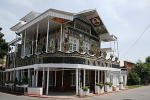
Bottle house of Ganja
Building in Ganja, Azerbaijan
Distance: Approx. 434 meters
Latitude and longitude: 40.68176,46.35564
Bottle House (Azerbaijani: Butulka ev/Butulkali ev) is an unusual private residence in Ganja built from glass bottles.

Nizami Ganjavi Ganja State History-Ethnography Museum
History museum in Ganja, Azerbaijan
Distance: Approx. 368 meters
Latitude and longitude: 40.68027778,46.35777778
Ganja State History-Ethnography Museum named after Nizami Ganjavi (Azerbaijani: Nizami Gəncəvi adına Tarix-Diyarşünaslıq Muzeyi) is the largest museum in Ganja,

Chokak Hamam
Distance: Approx. 645 meters
Latitude and longitude: 40.6773,46.3582
Chokak Hamam (Azerbaijani: Çökək hamam, "fallen bath") is a historical bath near Juma Mosque in Ganja. Historical-architectural monument built in 1606 , by order of Shah Abbas. The bathhouse was included in the list of immovable historical and cultural monuments of local significance by the decision No.
Siege of Ganja (1213)
1213 successful siege of the city of Ganja, by the Georgians under King George IV
Distance: Approx. 4 meters
Latitude and longitude: 40.68277778,46.36055556
The siege of Ganja was the successful siege of the city of Ganja, by the Georgians under King George IV in 1213.

Ganja-Dashkasan Economic Region
Economic region of Azerbaijan
Distance: Approx. 631 meters
Latitude and longitude: 40.68602778,46.36675
Ganja-Dashkasan Economic Region (Azerbaijani: Gəncə-Daşkəsən iqtisadi rayonu) is one of the 14 economic regions of Azerbaijan. It borders Georgia to the north and Armenia to the south, as well as the economic regions of Shaki-Zagatala, Central Aran, Karabakh, East Zangezur, and Gazakh-Tovuz. The region consists of the districts of Dashkasan, Goranboy, Goygol, Samukh, as well as the cities of Ganja and Naftalan.

Shah Abbas Square
Square in Ganja, Azerbaijan
Distance: Approx. 553 meters
Latitude and longitude: 40.678,46.3589
Shah Abbas Square is a square located in the historical center of the city of Ganja, Azerbaijan. At one time, it was the main memorial complex of the suburb of the Ganja fortress. The complex of Shah Abbas Square was firstly mentioned in the plan of the Ganja fortress of 1797.
Weather in this IP's area
broken clouds
11 Celsius
10 Celsius
11 Celsius
11 Celsius
1024 hPa
54 %
1024 hPa
967 hPa
10000 meters
6.17 m/s
270 degree
75 %
