85.122.180.142 - IP Lookup: Free IP Address Lookup, Postal Code Lookup, IP Location Lookup, IP ASN, Public IP
Country:
Region:
City:
Location:
Time Zone:
Postal Code:
ISP:
ASN:
language:
User-Agent:
Proxy IP:
Blacklist:
IP information under different IP Channel
ip-api
Country
Region
City
ASN
Time Zone
ISP
Blacklist
Proxy
Latitude
Longitude
Postal
Route
db-ip
Country
Region
City
ASN
Time Zone
ISP
Blacklist
Proxy
Latitude
Longitude
Postal
Route
IPinfo
Country
Region
City
ASN
Time Zone
ISP
Blacklist
Proxy
Latitude
Longitude
Postal
Route
IP2Location
85.122.180.142Country
Region
arad
City
arad
Time Zone
Europe/Bucharest
ISP
Language
User-Agent
Latitude
Longitude
Postal
ipdata
Country
Region
City
ASN
Time Zone
ISP
Blacklist
Proxy
Latitude
Longitude
Postal
Route
Popular places and events near this IP address

Arad County (former)
County of the Kingdom of Hungary
Distance: Approx. 5 meters
Latitude and longitude: 46.18333333,21.31666667
Arad County was an administrative unit in the Kingdom of Hungary, the Eastern Hungarian Kingdom and the Principality of Transylvania. The county was established along the Maros (Mureș) River in the 11th or the 12th century, but its first head, or ispán, was only mentioned in 1214. Its territory is now part of Romania, except a small area (the town of Elek and the surrounding villages) which is part of Hungary.

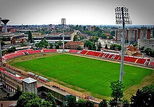
Stadionul Francisc von Neuman (1946)
Distance: Approx. 1109 meters
Latitude and longitude: 46.192575,21.31144167
Francisc von Neuman Stadium was a multi-purpose stadium in Arad, Romania. It was used mostly for football matches and was the home ground of FC UTA Arad, one of the most successful teams in Romanian club football. The stadium used to hold up to 7,287 people, all on seats, and was built in 1944.

Arad, Romania
Municipality in Arad County, Romania
Distance: Approx. 979 meters
Latitude and longitude: 46.175,21.3125
Arad (Romanian pronunciation: [aˈrad] ) is the capital city of Arad County, at the edge of Crișana and the Banat. No villages are administered by the city. It is the third largest city in Western Romania, behind Timișoara and Oradea, and the 12th largest in Romania, with a population of 145,078.
Aurel Vlaicu University of Arad
University in Arad, Romania
Distance: Approx. 1076 meters
Latitude and longitude: 46.17363889,21.31713889
Aurel Vlaicu University of Arad is a public university founded in 1990 in Arad, Romania. It was named in honor of the Romanian engineer and aviation pioneer Aurel Vlaicu.

Castra of Aradul Nou
Fort in the Roman province of Dacia
Distance: Approx. 5 meters
Latitude and longitude: 46.18333333,21.31666667
The castra of Aradul Nou was a fort in the Roman province of Dacia, located on the western side of the defensive line of forts, limes Daciae. It is situated near Arad, Romania.

Arad Central railway station
Railway station in Arad, Romania
Distance: Approx. 942 meters
Latitude and longitude: 46.189591,21.324871
Arad Central railway station (Romanian: Gara Centrală din Arad) is the largest railway station in the city of Arad, and the largest in the Arad County. It is the second largest railway station in the western region of Romania, immediately after Timișoara Nord railway station.

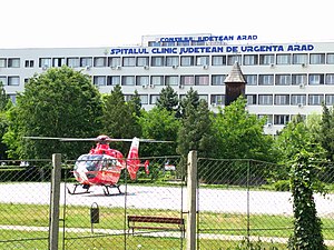
Arad County Clinical Hospital
Hospital in Arad County, Romania
Distance: Approx. 647 meters
Latitude and longitude: 46.1868463,21.3100433
Arad County Emergency Clinical Hospital (Romanian: Spitalul Clinic Județean de Urgență Arad) is a major hospital located at 2-4 Andrényi Károly Street, Arad, Romania. The hospital serves the whole Arad County and neighboring counties. The hospital is a multipurpose facility with 1322 beds, being one of the largest hospitals in the country.

Arad Administrative Palace
Heritage site in Arad County, Romania
Distance: Approx. 883 meters
Latitude and longitude: 46.17554746,21.31913394
The Arad Administrative Palace is an historic building located at 75 Revoluției Boulevard, Arad, Romania. It houses the city hall and the prefecture of Arad County.

Neumann Palace
Distance: Approx. 892 meters
Latitude and longitude: 46.1753,21.3174
The Neumann Palace is an eclectic building located in Arad. It is a historical monument. It was built in 1891–1892 by the wealthy family of Neumann.

Holy Trinity Cathedral, Arad
Romanian orthodox cathedral
Distance: Approx. 619 meters
Latitude and longitude: 46.18359444,21.32472222
The 'Holy Trinity' Orthodox Cathedral (Romanian: Catedrala "Sfânta Treime" din Arad) is a Romanian Orthodox cathedral in Arad, in the Crișana region of western Romania. It is the main cathedral of the episcopal see of Arad, currently headed by Timotei, Archbishop of Arad.

Francisc von Neuman Stadium
Romanian soccer stadium
Distance: Approx. 1088 meters
Latitude and longitude: 46.1925,21.31194444
Francisc von Neuman Stadium is a football stadium in Arad, Romania. It is built on the site of the former Francisc von Neuman Stadium. The stadium was opened on 28 August 2020 and currently serves as the home for UTA Arad of the Liga I. The stadium shares designing elements from Kirklees Stadium in Huddersfield which is visible in the stands.

St. Anthony of Padua Church (Arad, Romania)
Roman Catholic church in Arad, Romania
Distance: Approx. 1204 meters
Latitude and longitude: 46.1725117,21.31566397
St. Anthony of Padua Church is a Roman Catholic church located at 96A Revoluției Boulevard in Arad, Romania. It is dedicated to Saint Anthony of Padua.
Weather in this IP's area
clear sky
13 Celsius
12 Celsius
13 Celsius
15 Celsius
1008 hPa
70 %
1008 hPa
994 hPa
10000 meters
4.63 m/s
150 degree