Country:
 Belgium
Region:
City:
Latitude and Longitude:
Time Zone:
Postal Code:
IP information under different IP Channel
ip-api
Country
Region
City
ASN
Time Zone
ISP
Blacklist
Proxy
Latitude
Longitude
Postal
Route
IPinfo
Country
Region
City
ASN
Time Zone
ISP
Blacklist
Proxy
Latitude
Longitude
Postal
Route
MaxMind
Country
Region
City
ASN
Time Zone
ISP
Blacklist
Proxy
Latitude
Longitude
Postal
Route
Luminati
Country
BERegion
bru
City
brussels
ASN
Time Zone
Europe/Brussels
ISP
VERIXI SA
Latitude
Longitude
Postal
db-ip
Country
Region
City
ASN
Time Zone
ISP
Blacklist
Proxy
Latitude
Longitude
Postal
Route
ipdata
Country
Region
City
ASN
Time Zone
ISP
Blacklist
Proxy
Latitude
Longitude
Postal
Route
Popular places and events near this IP address

Schaerbeek
Municipality of the Brussels-Capital Region, Belgium
Distance: Approx. 450 meters
Latitude and longitude: 50.8675,4.37361111
Schaerbeek (French: [skaʁbek, -bɛk] ; also archaic Dutch) or Schaarbeek (Dutch: [ˈsxaːrbeːk] ) is one of the 19 municipalities of the Brussels-Capital Region, Belgium. Located in the north-eastern part of the region, it is bordered by the City of Brussels, Etterbeek, Evere and Saint-Josse-ten-Noode. In common with all of Brussels' municipalities, it is legally bilingual (French–Dutch).
LUCA School of Arts
Art college in Belgium
Distance: Approx. 1262 meters
Latitude and longitude: 50.86149444,4.36677222
Hogeschool Sint-Lukas Brussel (the "LUCA School of Arts") is an independent Flemish art school based in the Schaerbeek municipality of Brussels, Belgium. It is a predominantly Dutch-speaking institution located on the Paleizenstraat/Rue de Palais, and at another site, within reachable distance of Brussels' North Station. The Hogeschool provides exclusively art-related university-level higher education, hence the name.
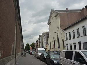
Rue d'Aerschot
Street in Schaerbeek, Belgium
Distance: Approx. 1278 meters
Latitude and longitude: 50.86277778,4.36361111
The Rue d'Aerschot (French) or Aarschotstraat (Dutch) is a street in the Schaerbeek municipality of Brussels, Belgium. It is known as a hotspot of the city's underground nightlife and famous for its brothels. The street is also known for its inexpensive lodging.

Josaphat Park
Park in Schaerbeek, Belgium
Distance: Approx. 1200 meters
Latitude and longitude: 50.86222222,4.385
Josaphat Park (French: Parc Josaphat; Dutch: Josaphatpark) is a public park of 20 ha (49 acres) located in the municipality of Schaerbeek in Brussels, Belgium. The football stadium that was formerly used by the K.V.V. Crossing Elewijt lies on the north-western corner of the park. There is also an elementary school (Chazal school), a tennis club (R.T.C. Lambermont), the municipal greenhouses, animals (horses, donkeys, hen, ducks), two playgrounds, a minigolf course, an archery range, three cafés (La Laiterie, La Buvette Saint-Sebastiaan, and La Guinguette Populeir), a kiosk (Josaphine's), and some ponds.

Schaarbeek railway station
Railway station in Brussels, Belgium
Distance: Approx. 794 meters
Latitude and longitude: 50.87805556,4.37944444
Schaerbeek railway station (French: Gare de Schaerbeek) or Schaarbeek railway station (Dutch: Station Schaarbeek) is a railway station in the municipality of Schaerbeek in Brussels, Belgium, opened in 1887. The train services are operated by the National Railway Company of Belgium (NMBS/SNCB). Located to the north-east of Brussels, the station mainly serves trains travelling between central Brussels and Leuven, Antwerp or Brussels Airport-Zaventem.
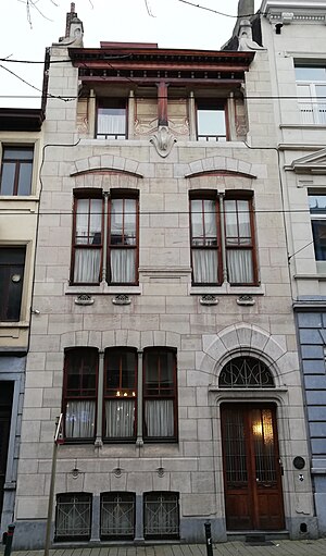
Autrique House
Historic Art Nouveau house in Brussels, Belgium
Distance: Approx. 938 meters
Latitude and longitude: 50.86305556,4.37305556
The Autrique House (French: Maison Autrique; Dutch: Autrique Huis) is a historic town house in Brussels, Belgium. This house, built in 1893, was the first designed by Victor Horta in Art Nouveau style, and represents an essential step in the evolution of the Belgian architect. In many ways, it was an innovative dwelling, although it does not feature the novel spatial composition of the almost contemporary Hôtel Tassel.

Brusilia
Curved high-rise building in Brussels, Belgium
Distance: Approx. 763 meters
Latitude and longitude: 50.86483,4.37937
The Résidence Brusilia is a curved high-rise in the Schaerbeek municipality of Brussels, Belgium, next to Josaphat Park. It was designed by the architect Jacques Cuisinier and built from 1970 to 1974. At 35 stories and 100 metres (330 ft) tall, it remained the tallest all-residential building in Belgium until the 142-metre-tall (466 ft) UP-Site tower was completed in Brussels in 2014.

Saint Mary's Royal Church
Church in Schaerbeek, Belgium
Distance: Approx. 1435 meters
Latitude and longitude: 50.85916667,4.36888889
Saint Mary's Royal Church (French: Église Royale Sainte-Marie; Dutch: Koninklijke Sint-Mariakerk) is a Roman Catholic parish church located on the Place de la Reine/Koninginneplein in the Brussels municipality of Schaerbeek, Belgium. Officially dedicated to Our Lady of the Assumption, it is popularly associated with Queen Louise-Marie, first Queen of the Belgians, as is the square where it is located, which earned it the title of "Royal". This site is served by the Botanique/Kruidtuin metro station on lines 2 and 6 of the Brussels Metro.

Train World
Railway museum in Brussels, Belgium
Distance: Approx. 794 meters
Latitude and longitude: 50.87805556,4.37944444
Train World is a railway museum in Schaerbeek, a municipality of Brussels, Belgium, and the official museum of the National Railway Company of Belgium (NMBS/SNCB). It is situated in the preserved buildings of Schaarbeek railway station and in a new shed built to its north. Although scheduled to open in 2014, its opening was delayed until September 2015, when it was solemnly opened by King Philippe.

Schaerbeek Beer Museum
Museum of Belgian beers in Brussels, Belgium
Distance: Approx. 889 meters
Latitude and longitude: 50.86333333,4.375
The Schaerbeek Beer Museum (French: Musée schaerbeekois de la bière; Dutch: Schaarbeeks Biermuseum) is a museum dedicated to Belgian beers in Schaerbeek, a municipality of Brussels, Belgium. The museum, which is a not-for-profit association (in Belgium, an asbl), was founded in 1993 and officially opened in March 1994. The museum houses a collection of more than 1000 bottles of Belgian beer and their respective beer glasses.

Halles de Schaerbeek
Cultural centre in Brussels, Belgium
Distance: Approx. 1321 meters
Latitude and longitude: 50.8601,4.3696
The Halles de Schaerbeek (Dutch: Hallen van Schaarbeek) is a cultural centre in Brussels, Belgium. It is located at 22, rue Royale Sainte-Marie/Koninklijke Sinte-Mariastraat in Schaerbeek, in the former Sainte-Marie covered market, built in 1865 and destroyed by a fire in 1898.
Schaerbeek Municipal Hall
Municipal hall building in Schaerbeek, Belgium
Distance: Approx. 450 meters
Latitude and longitude: 50.8675,4.37361111
The Municipal Hall (French: Hôtel communal; Dutch: Gemeentehuis) of Schaerbeek is the municipal hall building and the seat of that municipality of Brussels, Belgium. Designed by the architect Jules Jacques Van Ysendyck in neo-Flemish Renaissance style and completed in 1887, it is located at the centre of the Place Colignon/Colignonplein. This site is served by the tram stop Pavillon/Paviljoen (on line 55).
Weather in this IP's area
clear sky
24 Celsius
24 Celsius
23 Celsius
25 Celsius
1021 hPa
60 %
1021 hPa
1018 hPa
10000 meters
4.12 m/s
60 degree
07:24:29
19:48:00