Country:
Region:
City:
Latitude and Longitude:
Time Zone:
Postal Code:
IP information under different IP Channel
ip-api
Country
Region
City
ASN
Time Zone
ISP
Blacklist
Proxy
Latitude
Longitude
Postal
Route
Luminati
Country
Region
bru
City
brussels
ASN
Time Zone
Europe/Brussels
ISP
VERIXI SA
Latitude
Longitude
Postal
IPinfo
Country
Region
City
ASN
Time Zone
ISP
Blacklist
Proxy
Latitude
Longitude
Postal
Route
db-ip
Country
Region
City
ASN
Time Zone
ISP
Blacklist
Proxy
Latitude
Longitude
Postal
Route
ipdata
Country
Region
City
ASN
Time Zone
ISP
Blacklist
Proxy
Latitude
Longitude
Postal
Route
Popular places and events near this IP address
Brussels Faculty for Protestant Theology
Distance: Approx. 304 meters
Latitude and longitude: 50.83554722,4.40441389
The Faculté Universitaire de Théologie Protestante (Faculty of Protestant Theology in Brussels; FUTP) is a private university in Brussels, Belgium. Its official languages are French and Dutch.

ICHEC Brussels Management School
Management school in Brussels, Belgium
Distance: Approx. 102 meters
Latitude and longitude: 50.83805556,4.40861111
ICHEC Brussels Management School, officially Institut catholique des Hautes Études commerciales, is a Brussels-based management school, constituting the economic category of the "Haute École ICHEC - ECAM - ISFSC". It also has several training and research centers. ICHEC offers university-level management training programs in both daytime and evening courses, in both initial and continuing education.

Montgomery metro station
Metro station in Brussels, Belgium
Distance: Approx. 62 meters
Latitude and longitude: 50.83777778,4.40694444
Montgomery is an underground station on the Brussels Metro, the first station on the eastern branch of line 1 (formerly line 1B), in the Brussels-Capital Region, Belgium. The station also serves a number of tram lines and buses: Brussels tram routes 7 and 25 pass through, and 39 and 44 terminate there, while tram route 81 and a number of buses stop at surface level.

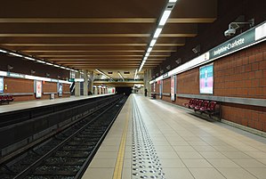
Joséphine-Charlotte metro station
Metro station in Brussels, Belgium
Distance: Approx. 465 meters
Latitude and longitude: 50.84,4.41277778
Joséphine-Charlotte is a Brussels Metro station on the eastern branch of line 1. It is located in the municipality of Woluwe-Saint-Lambert, in the eastern part of Brussels, Belgium. The station is located entirely below the Avenue de Broqueville/De Broquevillelaan.

Avenue de Tervueren
Thoroughfare in Brussels, Belgium
Distance: Approx. 297 meters
Latitude and longitude: 50.83666667,4.41166667
The Avenue de Tervueren (French: [avny də tɛʁvyʁœn]) or Tervurenlaan (Dutch: [tɛrˈvyːrə(n)ˌlaːn]) is a major thoroughfare in Brussels, Belgium. It was originally commissioned by King Leopold II as part of his building campaign, and was finished in 1897, in time for the Brussels International Exhibition of that year. Geographically, the Avenue de Tervueren forms a continuation of the Rue de la Loi/Wetstraat, which ends at the western end of the Parc du Cinquantenaire/Jubelpark, running from Merode station in the west, connecting with Square Maréchal Montgomery/Maarschalk Montgomeryplein, passing through the municipality of Woluwe-Saint-Pierre and the Ring at Quatre Bras/Vier Armen, and finishing at the park in Tervuren.
Church of St. John Berchmans, Brussels
Church in Etterbeek, Belgium
Distance: Approx. 299 meters
Latitude and longitude: 50.83472222,4.40722222
The Church of St. John Berchmans (French: Église Saint-Jean-Berchmans; Dutch: Sint-Jan-Berchmanskerk) is the Catholic church of St. Michael's College in the Brussels municipality of Etterbeek, Belgium.

Boileau premetro station
Premetro station in Brussels, Belgium
Distance: Approx. 605 meters
Latitude and longitude: 50.83222,4.405
Boileau is a premetro (underground tram) station located in the municipality of Etterbeek in Brussels, Belgium. The station opened on 30 January 1975. Named for the nearby Rue Boileau/Boileaustraat, it is situated on the Boulevard Saint-Michel/Sint-Michielslaan section of the Greater Ring, adjacent to the Boileau tunnel.
Georges Henri premetro station
Premetro station in Brussels, Belgium
Distance: Approx. 607 meters
Latitude and longitude: 50.84277,4.4061
Georges Henri is a premetro (underground tram) station located in the municipality of Woluwe-Saint-Lambert in Brussels, Belgium. The station opened on 30 January 1975. Named for the Avenue Georges Henri/Georges Henrilaan, which runs perpendicular to the Greater Ring at the south end of the station, it is located on the Boulevard Brand Whitlock/Brand Whitlocklaan section of the Greater Ring.
St. Michael's College, Brussels
Distance: Approx. 344 meters
Latitude and longitude: 50.83437,4.40858
St. Michael's College (French: Collège Saint-Michel) is a Roman Catholic secondary school in the Brussels municipality of Etterbeek, Belgium. The school was built in 1905 by the Society of Jesus in order to replace the previous school that had become too small.

Square Maréchal Montgomery
Square in Brussels, Belgium
Distance: Approx. 13 meters
Latitude and longitude: 50.8375,4.4075
The Square Maréchal Montgomery (Dutch: Maarschalk Montgomeryplein), usually shortened to the Square Montgomery, or Montgomery by locals, is a major intersection in the Brussels municipality of Woluwe-Saint-Pierre, Belgium. It is named in honour of Field Marshal Bernard Montgomery, a senior British Army officer who served in the First World War, the Irish War of Independence and the Second World War. It is situated on the intersection of the Avenue de Tervueren/Tervurenlaan, the Boulevard Brand Whitlock/Brand Whitlocklaan and the Boulevard Saint-Michel/Sint-Michielslaan.
Artiscope Gallery
Art gallery in Brussels, Belgium
Distance: Approx. 257 meters
Latitude and longitude: 50.83532,4.406
Artiscope is a Brussels art gallery specialized in contemporary American and European artists. Artiscope Gallery has organized exhibitions in collaboration with many museums in Belgium and Germany.
List of ambassadors of Rwanda to Belgium
Distance: Approx. 535 meters
Latitude and longitude: 50.833013,4.404503
The Rwandan Ambassador to Belgium is the official representative of the Government of Rwanda to the Government of Belgium he is concurrently accredited to the European Commission, the government in The Hague and the Holy See.
Weather in this IP's area
mist
4 Celsius
4 Celsius
2 Celsius
6 Celsius
1023 hPa
95 %
1023 hPa
1012 hPa
2500 meters
0.51 m/s
100 %
07:41:30
17:10:26

