Country:
 Great Britain
Region:
City:
Latitude and Longitude:
Time Zone:
Postal Code:
IP information under different IP Channel
ip-api
Country
Region
City
ASN
Time Zone
ISP
Blacklist
Proxy
Latitude
Longitude
Postal
Route
IPinfo
Country
Region
City
ASN
Time Zone
ISP
Blacklist
Proxy
Latitude
Longitude
Postal
Route
MaxMind
Country
Region
City
ASN
Time Zone
ISP
Blacklist
Proxy
Latitude
Longitude
Postal
Route
Luminati
Country
GBASN
Time Zone
Europe/London
ISP
Kda Web Services Ltd
Latitude
Longitude
Postal
db-ip
Country
Region
City
ASN
Time Zone
ISP
Blacklist
Proxy
Latitude
Longitude
Postal
Route
ipdata
Country
Region
City
ASN
Time Zone
ISP
Blacklist
Proxy
Latitude
Longitude
Postal
Route
Popular places and events near this IP address
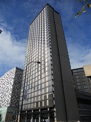
St Paul's Tower
Skyscraper in Sheffield, England
Distance: Approx. 226 meters
Latitude and longitude: 53.378947,-1.468277
St Paul's Tower is a skyscraper located on Arundel Gate in Sheffield, South Yorkshire, England. Construction commenced in May 2006 and the building was topped out in August 2010, surpassing Sheffield University's Arts Tower as the tallest building in Sheffield at 101 metres (331 ft) tall. The city's first skyscraper, it was constructed as the centrepiece of the St Paul's Place project as part of the Heart of the City redevelopment of Sheffield city centre.
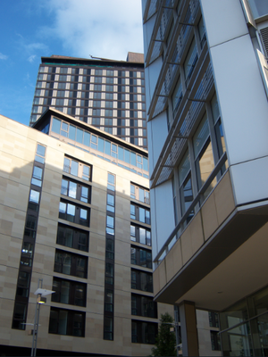
St Paul's Place
Distance: Approx. 140 meters
Latitude and longitude: 53.379,-1.47
St Paul's Place is part of the Heart of the City project in Sheffield, South Yorkshire, England. It encompasses the new office blocks surrounding the Peace Gardens, the car park and is linked to the St. Pauls Tower.

Gatecrasher One
Distance: Approx. 239 meters
Latitude and longitude: 53.3761,-1.4696
Gatecrasher One was a nightclub in Sheffield, South Yorkshire, England. The club was a converted warehouse owned by the Gatecrasher dance music brand. The nightclub was originally named The Republic, but this was changed in 2003 after a £1.5 million refurbishment.

St Paul's Church, Sheffield
Church in Sheffield, South Yorkshire, England
Distance: Approx. 207 meters
Latitude and longitude: 53.3797,-1.47
See also St Paul's Church and Centre, Norton Lees, Sheffield and Sheffield Cathedral, which is dedicated to St Peter and St Paul. St Paul's Church, Sheffield, was a chapel of ease to Sheffield Parish Church. By 1700, Sheffield's population had reached 5,000, and a second Anglican place of worship was required to house a growing congregation.
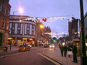
Pinstone Street
Distance: Approx. 148 meters
Latitude and longitude: 53.379268,-1.47059
Pinstone Street is a part-pedestrianised road located in Sheffield, England. It connects the two main shopping areas of Fargate and The Moor in the centre of the city. Originally called Pinstone Lane, its eastern side contains Sheffield Town Hall and the Peace Gardens.

St Matthew's Church, Sheffield
Anglican church in Sheffield, South Yorkshire, England
Distance: Approx. 223 meters
Latitude and longitude: 53.3796,-1.4733
St Matthew's Church, more usually known as St Matthew's Carver Street, is situated on Carver Street in the centre of Sheffield, South Yorkshire, England. It is a Grade II listed building located at grid reference SK351871. The church is part of the Anglo-Catholic movement.
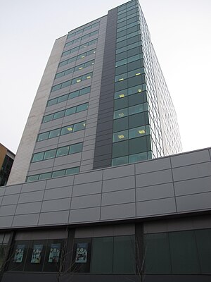
Redvers House
Distance: Approx. 51 meters
Latitude and longitude: 53.377937,-1.470513
Redvers House is an office block situated on Union Street in the centre of the city of Sheffield in South Yorkshire, England. Redvers House was built in 1971 by the construction firm Newman Doncaster Associates. It is owned by Sheffield City Council and the top 11 stories are used as offices by certain sections of their Social Services department as offices.
Midcity Tower
Residential, Retail in Sheffield, England
Distance: Approx. 19 meters
Latitude and longitude: 53.378,-1.471
Midcity Tower (previously known by its street address, 23 Furnival Gate) is an approved tower in Sheffield, England. Plans were submitted in 2005 and accepted later the same year. Construction is yet to start as of 2016, and proposed plans would mean the demolition of 'The Nelson' public house.

The Gate, Sheffield
Residential, Hotel in Sheffield, England
Distance: Approx. 140 meters
Latitude and longitude: 53.377,-1.47
The Gate is a residential tower located at 1 Eyre Street in Sheffield, England. Plans were submitted in 2006 and accepted that year. Construction started in 2007, however the project was placed on hold in January 2009 as a result of the Great Recession.

Vita Student Sheffield
Office (1972–2012), Vacant (2012–2015), Residential (2015–) in Sheffield, South Yorkshire
Distance: Approx. 164 meters
Latitude and longitude: 53.378343,-1.473686
Vita Student Sheffield (known as Telephone House prior to 2014) is a high-rise building on Wellington Street, near Charter Row in Sheffield city centre. It is 56 metres tall and has sixteen floors. When completed in 1972, it was Sheffield's third-tallest building; as of May 2020, it is now the ninth-tallest.
Leah's Yard
Building in South Yorkshire, England
Distance: Approx. 201 meters
Latitude and longitude: 53.3797,-1.4723
Leah's Yard is a former collection of small industrial workshops situated on Cambridge Street in the city centre of Sheffield in South Yorkshire, England. The building has been designated as a Grade II* listed building because of its importance as an example of Sheffield's industrial heritage and has recently undergone a significant restoration to bring it back into use.

Code (nightclub)
Nightclub in Sheffield, England
Distance: Approx. 132 meters
Latitude and longitude: 53.37686,-1.47074
Code is a nightclub in Sheffield, England. It is located on Eyre Street in Sheffield City Centre and plays contemporary chart music including pop, hip hop and R&B. Code was voted Sheffield's Nightclub of the Year every year from 2016 to 2022; its main competitors are Corporation and The Leadmill. On 13 October 2022, it was announced that Code would be closing due to rising costs associated with the COVID-19 recession and the global energy crisis, with the final club night closing party taking place later that year on 26 November.
Weather in this IP's area
scattered clouds
14 Celsius
14 Celsius
14 Celsius
16 Celsius
995 hPa
74 %
995 hPa
985 hPa
10000 meters
1.28 m/s
1.32 m/s
154 degree
49 %
07:18:31
18:28:26