Country:
 Netherlands
Region:
City:
Latitude and Longitude:
Time Zone:
Postal Code:
IP information under different IP Channel
ip-api
Country
Region
City
ASN
Time Zone
ISP
Blacklist
Proxy
Latitude
Longitude
Postal
Route
IPinfo
Country
Region
City
ASN
Time Zone
ISP
Blacklist
Proxy
Latitude
Longitude
Postal
Route
MaxMind
Country
Region
City
ASN
Time Zone
ISP
Blacklist
Proxy
Latitude
Longitude
Postal
Route
Luminati
Country
NLRegion
fl
City
dronten
ASN
Time Zone
Europe/Amsterdam
Latitude
Longitude
Postal
db-ip
Country
Region
City
ASN
Time Zone
ISP
Blacklist
Proxy
Latitude
Longitude
Postal
Route
ipdata
Country
Region
City
ASN
Time Zone
ISP
Blacklist
Proxy
Latitude
Longitude
Postal
Route
Popular places and events near this IP address
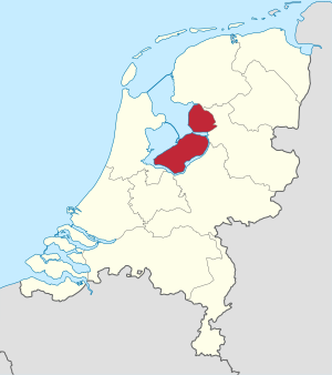
Flevoland
Province of the Netherlands
Distance: Approx. 2087 meters
Latitude and longitude: 52.53333333,5.66666667
Flevoland (Dutch pronunciation: [ˈfleːvoːlɑnt] ) is the twelfth and newest province of the Netherlands, established in 1986, when the southern and eastern Flevopolders, together with the Noordoostpolder, were merged into one provincial entity. It is in the centre of the country in the former Zuiderzee, which was turned into the freshwater IJsselmeer by the closure of the Afsluitdijk in 1932. Almost all of the land belonging to Flevoland was reclaimed in the 1950s and 1960s while splitting the Markermeer and Bordering lakes from the IJsselmeer.

Dronten
Municipality in Flevoland, Netherlands
Distance: Approx. 2717 meters
Latitude and longitude: 52.51666667,5.71666667
Dronten (Dutch pronunciation: [ˈdrɔntə(n)] ) is a municipality and a town in the central Netherlands, in the province of Flevoland. It had a population of 42,011 in 2021.

Biddinghuizen
Village in Flevoland, The Netherlands
Distance: Approx. 9311 meters
Latitude and longitude: 52.45416667,5.69416667
Biddinghuizen (Dutch pronunciation: [ˌbɪdɪŋˈɦœyzə(n)]) is a village in the municipality of Dronten in the Netherlands. It is situated in the center of the province of Flevoland, about 13 km north of the city of Harderwijk. On 1 January 2018, the village had 6,295 inhabitants.

Swifterbant
Village in Flevoland, Netherlands
Distance: Approx. 4976 meters
Latitude and longitude: 52.5675,5.64166667
Swifterbant (Dutch pronunciation: [ˌsʋɪftərˈbɑnt]) is a town in the Dutch province of Flevoland. It is a part of the municipality of Dronten, and lies about 13 km northeast of Lelystad. On 1 January 2014, Swifterbant had 6475 inhabitants.

Ketelbrug
Distance: Approx. 8969 meters
Latitude and longitude: 52.61194444,5.64472222
The Ketelbrug is bridge spanning the Ketel-lake between the Noordoostpolder and the Eastern Flevopolder in the Dutch province of Flevoland. The motorway A6 runs over it. A part of it is a Bascule bridge.

Dronten railway station
Railway station in the Netherlands
Distance: Approx. 1844 meters
Latitude and longitude: 52.53388889,5.72305556
Dronten is a Dutch railway station, on the Lelystad–Zwolle railway, also knowns as the Hanzelijn. The station is located in the north of Dronten. The station opened on 9 December 2012, with there being 2 platforms and 4 tracks, for passing Intercities from The Hague and Schiphol to Groningen and Leeuwarden.
Ketelmeer
Bordering lake in Flevoland, Overijssel
Distance: Approx. 8125 meters
Latitude and longitude: 52.60666667,5.73638889
The Ketelmeer is the tongue of the IJsselmeer into which the River IJssel drains, it is situated between the polders Noordoostpolder (North-east Polder) and Oostelijk Flevoland (East Flevoland), and connects the river IJssel to the IJsselmeer. It is one of the bordering lakes, a continuous body of water which separate Flevoland from the Noordostpolder and the ancient lands of the provinces of Gelderland and Utrecht. The Ketelmeer covers an area of 3500 hectares, most of which is in the province of Flevoland, but the river delta of the IJssel is in province of Overijssel.
CAH Dronten
Agricultural school in the Netherlands
Distance: Approx. 1153 meters
Latitude and longitude: 52.5275,5.69833333
CAH Vilentum University of Applied Sciences is a professional university situated in the centre of the Netherlands - in one of the most modern food production areas in the world.
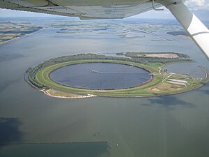
IJsseloog
Artificial island in Dronten
Distance: Approx. 7810 meters
Latitude and longitude: 52.6,5.75
The IJsseloog (Dutch pronunciation: [ˈɛisəlˌoːx], "IJssel eye") is an artificial island in the Ketelmeer (province of Flevoland, the Netherlands) used as a depository to store polluted silt. Most of the polluted silt was deposited in the Ketelmeer by the IJssel river between 1950 and 1990. Removal of silt soil from the Ketelmeer lake also aims to deepen the channel leading to the mouth of the IJssel to at least a depth of 3.5 m (11.5 ft), thus aiming to improve access to the river for navigation.
Weather in this IP's area
clear sky
15 Celsius
15 Celsius
13 Celsius
16 Celsius
1027 hPa
94 %
1027 hPa
1027 hPa
10000 meters
3.9 m/s
7.77 m/s
57 degree
7 %
07:18:36
19:43:20