85.117.22.67 - IP Lookup: Free IP Address Lookup, Postal Code Lookup, IP Location Lookup, IP ASN, Public IP
Country:
Region:
City:
Location:
Time Zone:
Postal Code:
IP information under different IP Channel
ip-api
Country
Region
City
ASN
Time Zone
ISP
Blacklist
Proxy
Latitude
Longitude
Postal
Route
Luminati
Country
Region
12
City
tarnow
ASN
Time Zone
Europe/Warsaw
ISP
Multimedia Polska Sp. z o.o.
Latitude
Longitude
Postal
IPinfo
Country
Region
City
ASN
Time Zone
ISP
Blacklist
Proxy
Latitude
Longitude
Postal
Route
IP2Location
85.117.22.67Country
Region
malopolskie
City
tarnow
Time Zone
Europe/Warsaw
ISP
Language
User-Agent
Latitude
Longitude
Postal
db-ip
Country
Region
City
ASN
Time Zone
ISP
Blacklist
Proxy
Latitude
Longitude
Postal
Route
ipdata
Country
Region
City
ASN
Time Zone
ISP
Blacklist
Proxy
Latitude
Longitude
Postal
Route
Popular places and events near this IP address

Tarnów
City in Lesser Poland Voivodeship, Poland
Distance: Approx. 185 meters
Latitude and longitude: 50.0125,20.98861111
Tarnów (Polish pronunciation: [ˈtarnuf] ) is a city in southeastern Poland with 105,922 inhabitants and a metropolitan area population of 269,000 inhabitants. The city is situated in the Lesser Poland Voivodeship. It is a major rail junction, located on the strategic east–west connection from Lviv to Kraków, and two additional lines, one of which links the city with the Slovak border.

Tarnów Voivodeship
Former administrative division of Poland
Distance: Approx. 185 meters
Latitude and longitude: 50.0125,20.988611
Tarnów Voivodeship (Polish: województwo tarnowskie) was a unit of administrative division and local government in Poland in years 1975–1998, superseded by a much larger Lesser Poland Voivodeship. Its capital city was Tarnów. Located in southeastern part of the country, its area was 4,151 km2.

Tarnów County
County in Lesser Poland Voivodeship, Poland
Distance: Approx. 2365 meters
Latitude and longitude: 50.03333333,21
Tarnów County (Polish: powiat tarnowski) is a unit of territorial administration and local government (powiat) in Lesser Poland Voivodeship, southern Poland. It came into being on January 1, 1999, as a result of the Polish local government reforms passed in 1998. Its administrative seat is the city of Tarnów, although the city is not part of the county (it constitutes a separate city county).

New Synagogue (Tarnów)
Destroyed synagogue in Tarnów, Poland
Distance: Approx. 277 meters
Latitude and longitude: 50.01416667,20.99083333
The New Synagogue (Polish: Nowa Synagoga), officially the New Synagogue of Tłomackie (Polish: Nowa Synagoga w Tarnowie), was a former Jewish congregation and synagogue, that was located on the corner of Nowa and Waryńskiego Streets, in Tarnów, in the Masovian Voivodeship of Poland. The synagogue was designed by Władysław Ekielski in the Moorish Revival style, commenced in 1865 and completed in 1908, the lack of funds delayed timely construction. The synagogue served as a house of prayer until World War II when it was set on fire by the Nazis in November 1939.

Roman Catholic Diocese of Tarnów
Roman Catholic diocese in Poland
Distance: Approx. 78 meters
Latitude and longitude: 50.0131,20.9871
The Diocese of Tarnów (Latin: Dioecesis Tarnoviensis) is a Latin diocese of the Catholic Church in Poland. According to Church statistics, it is the most religious diocese in Poland, with 72.5% weekly Mass attendance.
Gmina Tarnów
Gmina in Lesser Poland Voivodeship, Poland
Distance: Approx. 2365 meters
Latitude and longitude: 50.03333333,21
Gmina Tarnów is a rural gmina (administrative district) in Tarnów County, Lesser Poland Voivodeship, in southern Poland. Its seat is the city of Tarnów, although the city is not part of the territory of the gmina. The gmina covers an area of 82.81 square kilometres (32.0 sq mi), and as of 2006 its total population is 23,060.

Tarnów train station bombing
Bombing of railway station in Poland leading up to WWII
Distance: Approx. 1312 meters
Latitude and longitude: 50.00555556,20.97388889
The Tarnów train station bombing was a deadly bombing carried out by a German saboteur two days before the outbreak of World War II in Europe. The bombing occurred in the city of Tarnów, Poland during the interwar period, and preceded the joint invasion of Poland by Nazi Germany and the Soviet Union. A time bomb detonated inside the station on the night of 28 August 1939, resulting in the deaths of 20 people and injuries to 35 others.

State Higher Vocational School in Tarnow
Distance: Approx. 315 meters
Latitude and longitude: 50.0156,20.9904
State Higher Vocational School in Tarnów (Państwowa Wyższa Szkoła Zawodowa w Tarnowie) – a public, vocational type university, created on the basis of the Council of Ministers of 19 May 1998 as the first university in Poland of a new type of vocational educating undergraduate and engineering. The university operates under the Act of 26 June 1997 on higher vocational schools (Ustawa z dnia 26 czerwca 1997 roku o wyższych szkołach zawodowych), the statute and other regulations issued on its basis.

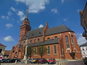
Tarnów Cathedral
Church in Tarnów, Poland
Distance: Approx. 79 meters
Latitude and longitude: 50.0131,20.9872
The Cathedral Basilica of the Nativity of the Blessed Virgin Mary (Polish: Bazylika katedralna Narodzenia Najświętszej Maryi Panny w Tarnowie ) also called Tarnów Cathedral is a religious building belonging to the Catholic Church and is located in the city of Tarnów in the European country of Poland. It is a Gothic church, rebuilt in later periods. The building has three naves with an elongated chancel and west tower added that one rises 72 meters.

Tarnów railway station
Railway station in Lesser Poland, Poland
Distance: Approx. 1376 meters
Latitude and longitude: 50.0057298,20.972428
Tarnów railway station is a railway station in Tarnów (Lesser Poland), Poland. As of 2022, it is served by Koleje Małopolskie (KMŁ), Polregio, and PKP Intercity (EIP, InterCity, and TLK services).

Akademiola (Tarnów)
Historic building in Tarnów, Poland
Distance: Approx. 86 meters
Latitude and longitude: 50.01305556,20.98666667
Akademiola in Tarnów (also known as scholasteria or chapter house) is a historic building located at 5 Cathedral Square in Tarnów. It was likely created by merging two other structures: the parish school building and the infirmary for collegiate vicars, built around the mid-16th century. Over its history, it was used, among other purposes, as the seat of educational institutions.

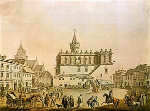
Tarnów Town Hall
Town hall in Tarnów, Poland
Distance: Approx. 178 meters
Latitude and longitude: 50.01247222,20.98838889
The Tarnów Town Hall is a 15th century town hall in Tarnów, Poland. It is on the register of monuments in Poland. The town hall is located in Tarnów's market square.
Weather in this IP's area
scattered clouds
2 Celsius
-0 Celsius
2 Celsius
2 Celsius
1032 hPa
81 %
1032 hPa
1005 hPa
10000 meters
1.87 m/s
2.34 m/s
136 degree
47 %