Country:
 Croatia
Region:
City:
Latitude and Longitude:
Time Zone:
Postal Code:
IP information under different IP Channel
ip-api
Country
Region
City
ASN
Time Zone
ISP
Blacklist
Proxy
Latitude
Longitude
Postal
Route
IPinfo
Country
Region
City
ASN
Time Zone
ISP
Blacklist
Proxy
Latitude
Longitude
Postal
Route
MaxMind
Country
Region
City
ASN
Time Zone
ISP
Blacklist
Proxy
Latitude
Longitude
Postal
Route
Luminati
Country
HRRegion
08
City
rijeka
ASN
Time Zone
Europe/Zagreb
ISP
Telemach Hrvatska d.o.o.
Latitude
Longitude
Postal
db-ip
Country
Region
City
ASN
Time Zone
ISP
Blacklist
Proxy
Latitude
Longitude
Postal
Route
ipdata
Country
Region
City
ASN
Time Zone
ISP
Blacklist
Proxy
Latitude
Longitude
Postal
Route
Popular places and events near this IP address
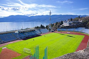
Stadion Kantrida
Croatian football stadium
Distance: Approx. 4353 meters
Latitude and longitude: 45.339202,14.380959
Kantrida Stadium (Croatian: Stadion Kantrida) is a football stadium in the Croatian city of Rijeka. It is named after the Kantrida neighbourhood in which it is located, in the western part of the city. It has served as the home of the HNK Rijeka football club for most years since at least 1918.
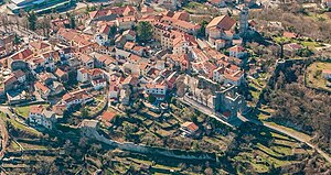
Kastav
Town in Primorje-Gorski Kotar, Croatia
Distance: Approx. 2452 meters
Latitude and longitude: 45.375,14.349
Kastav (Italian: Castua) is a town in Primorje-Gorski Kotar County, Croatia, built on a 365 m high hill overlooking the Kvarner Gulf on the northern coast of the Adriatic. It is in close vicinity of Rijeka, the largest port in Croatia, and the Opatija Riviera, one of the popular tourist destinations in the country.

Viškovo
Municipality in Primorje-Gorski Kotar County, Croatia
Distance: Approx. 481 meters
Latitude and longitude: 45.37777778,14.38611111
Viškovo is a village and a municipality in the Primorje-Gorski Kotar County in western Croatia.
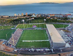
Stadion Rujevica
Stadium in Rijeka, Croatia
Distance: Approx. 3997 meters
Latitude and longitude: 45.34666667,14.40416667
Stadion Rujevica (English: Rujevica Stadium), officially known as Stadion HNK Rijeka (English: HNK Rijeka Stadium), is a stadium in the city of Rijeka, Croatia. The stadium is commonly referred to as Rujevica after its location. From August 2015, the stadium is a temporary home ground for HNK Rijeka during construction of the new Stadion Kantrida.
Drenova, Rijeka
Local board in Primorje-Gorski Kotar County, Croatia
Distance: Approx. 4869 meters
Latitude and longitude: 45.35333333,14.43111111
Drenova is a neighbourhood and a local board of the city of Rijeka, Croatia perched on a plateau above the city. Historically there were two parts: Gornja (Upper) Drenova and Donja (Lower) Drenova, nowadays united in one. Drenova has the largest cemetery and park area of the city.
Opatija Circuit
Motorsport circuit in Croatia
Distance: Approx. 4664 meters
Latitude and longitude: 45.35222222,14.33333333
Opatija Circuit, also known as Preluk Circuit and the Kvarner Circuit, was a motorsport street circuit in Opatija, Croatia. The circuit used the city streets of the seaside resort situated on the Kvarner Gulf between 1931 and 1977. It was known as the "Monaco" of the Grand Prix motorcycle racing circuit because of its dramatic views of the Adriatic Sea.
Saršoni
Village in Croatia
Distance: Approx. 2543 meters
Latitude and longitude: 45.38841864,14.40915758
Saršoni is a village in Croatia.
Jurdani
Village in Croatia
Distance: Approx. 4984 meters
Latitude and longitude: 45.38333333,14.31666667
Jurdani (Italian: Giordani) is a village in Matulji municipality in western Croatia.
HNK Rijeka Academy
Youth academy of Croatian football club Rijeka
Distance: Approx. 3806 meters
Latitude and longitude: 45.34788889,14.40225
HNK Rijeka Academy is the youth academy of HNK Rijeka. There are a total of eleven age categories within the academy, the oldest being the Juniori (under-19) and youngest the Morčići (under-8). Rijeka's football academy was officially founded in 1972.

Centar Zamet
Mixed-use sports hall in Rijeka, Croatia
Distance: Approx. 3786 meters
Latitude and longitude: 45.3443851,14.3836658
Centar Zamet (English: Centre Zamet), also rendered in English as Zamet Sports Centre, is a mixed-use sports hall in the Zamet neighbourhood of Rijeka, Croatia, that hosts sporting, cultural, business and entertainment events. The hall was built in Zamet in 2009. The size of the hall is 16,830 square metres (181,200 sq ft) and the surface of the outer space is 88,075 square metres (948,030 sq ft).
Kukuljani
Place in Primorje-Gorski Kotar County, Croatia
Distance: Approx. 4029 meters
Latitude and longitude: 45.40333333,14.41722222
Kukuljani (Italian: Cucugliani) is a village in the Primorje-Gorski Kotar County, Croatia. Administratively it belongs to the municipality of Jelenje.
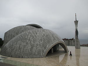
Rijeka Mosque
Mosque in Rijeka, Croatia
Distance: Approx. 3865 meters
Latitude and longitude: 45.3458,14.3974
Rijeka Mosque (Croatian and Bosnian: Džamija u Rijeci) is a mosque in Rijeka, Croatia built between 2009 and 2013. The project of the mosque and the cultural center was originally developed by Dušan Džamonja in cooperation with Branko Vučinović and Darko Vlahović. The entire project costed 76 million Croatian kuna with significant contribution by the state of Qatar.
Weather in this IP's area
overcast clouds
15 Celsius
14 Celsius
14 Celsius
16 Celsius
1018 hPa
75 %
1018 hPa
981 hPa
10000 meters
5.61 m/s
13.52 m/s
50 degree
99 %
06:47:19
19:04:25