Country:
Region:
City:
Latitude and Longitude:
Time Zone:
Postal Code:
IP information under different IP Channel
ip-api
Country
Region
City
ASN
Time Zone
ISP
Blacklist
Proxy
Latitude
Longitude
Postal
Route
Luminati
Country
Region
08
City
rijeka
ASN
Time Zone
Europe/Zagreb
ISP
Telemach Hrvatska d.o.o.
Latitude
Longitude
Postal
IPinfo
Country
Region
City
ASN
Time Zone
ISP
Blacklist
Proxy
Latitude
Longitude
Postal
Route
db-ip
Country
Region
City
ASN
Time Zone
ISP
Blacklist
Proxy
Latitude
Longitude
Postal
Route
ipdata
Country
Region
City
ASN
Time Zone
ISP
Blacklist
Proxy
Latitude
Longitude
Postal
Route
Popular places and events near this IP address

Šibenik
City in Šibenik-Knin, Croatia
Distance: Approx. 303 meters
Latitude and longitude: 43.735,15.89055556
Šibenik (Croatian: [ʃîbeniːk] ), historically known as Sebenico (Italian: [sebeˈniːko]), is a historic town in Croatia, located in central Dalmatia, where the river Krka flows into the Adriatic Sea. Šibenik is a political, educational, transport, industrial and tourist center of Šibenik-Knin County, and is also the third-largest town in the Dalmatian region. As of 2021, the town has 31,115 inhabitants, while the municipality has 42,599 inhabitants.

Šibenik Cathedral
Cathedral in Croatia
Distance: Approx. 434 meters
Latitude and longitude: 43.73566111,15.88914722
The Cathedral of St. James (Croatian: Katedrala sv. Jakova) in Šibenik, Croatia, is a triple-nave Catholic basilica with three apses and a dome (32 m high inside).

Stadion Šubićevac
Association football stadium in Šibenik, Croatia
Distance: Approx. 1041 meters
Latitude and longitude: 43.7435533,15.8960581
Stadion Šubićevac, also known simply as Šubićevac, is an association football stadium in Šibenik, Croatia. It is the home stadium of HNK Šibenik football club. The stadium has a capacity of 3,412, all of which is seated.

Roman Catholic Diocese of Šibenik
Roman Catholic diocese in Croatia
Distance: Approx. 458 meters
Latitude and longitude: 43.7358,15.8889
The Diocese of Šibenik (Latin: Dioecesis Sebenicensis; Croatian: Šibenska biskupija) is a Latin diocese of the Catholic Church located in the city of Šibenik in the ecclesiastical province of Split-Makarska in Croatia.

St. Nicholas Fortress
Distance: Approx. 3512 meters
Latitude and longitude: 43.722,15.854
St. Nicholas Fortress (Croatian: Tvrđava sv. Nikole) is a fortress located at the entrance to St.
Battle of Šibenik
Battle of the Croatian War of Independence
Distance: Approx. 586 meters
Latitude and longitude: 43.73,15.89
The Battle of Šibenik (Croatian: Bitka za Šibenik), also known as the September War (Rujanski rat), was an armed conflict fought between the Yugoslav People's Army (Jugoslovenska Narodna Armija – JNA), supported by the Croatian Serb-established Serbian Autonomous Oblast of Krajina (SAO Krajina), and the Croatian National Guard (Zbor Narodne Garde – ZNG), supported by the Croatian Police. The battle was fought to the north and west of the city of Šibenik, Croatia on 16–22 September 1991, during the Croatian War of Independence. The JNA's initial orders were to relieve Croatian siege of their barracks in the city and isolate the region of Dalmatia from the rest of Croatia.
St. Basil of Ostrog Monastery
Serbian Orthodox monastery
Distance: Approx. 250 meters
Latitude and longitude: 43.7364,15.8931
The St. Basil of Ostrog Monastery (Serbian: Манастир Светог Василија Острошког, romanized: Manastir Svetog Vasilija Ostroškog) is a Serbian Orthodox monastery dedicated to Saint Basil of Ostrog located in the village of Crnogorci near the town of Imotski in Dalmatia, Croatia. The construction of the monastery began in 2005, and it had been suspended in 2006 after protests from the municipality of Podbablje.
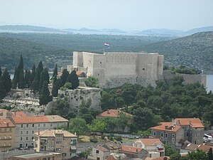
St. Michael's Fortress, Šibenik
Fortress in Šibenik, Croatia
Distance: Approx. 529 meters
Latitude and longitude: 43.7377,15.8896
St. Michael's Fortress (Croatian: Tvrđava sv. Mihovila; Venetian: Castel vecchio; formerly known as St.

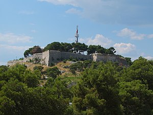
Barone Fortress
Fortress in Šibenik, Croatia
Distance: Approx. 378 meters
Latitude and longitude: 43.7373,15.8964
The Barone Fortress (also known as Šubićevac Fortress; Croatian: Tvrđava Barone or Tvrđava Šubićevac) in Šibenik, Croatia, is an early modern fortress constructed in 1646 on Vidakuša hill above the city. Together with the remaining three city fortresses, it is a part of the Šibenik fortification system. It played a significant role in city's defense from the Ottomans during the Cretan War.
St. John's Fortress, Šibenik
Distance: Approx. 602 meters
Latitude and longitude: 43.7397,15.8938
St. John's Fortress (also known as Tanaja; Croatian: Tvrđava sv. Ivana) is an early modern fortress in Šibenik, Croatia, situated atop a hill north of the city's historical center.

Banj beach
Beach in Croatia
Distance: Approx. 1099 meters
Latitude and longitude: 43.7411,15.8843
Banj Beach (Croatian: Plaža Banj) is the most famous beach based in Šibenik, Croatia. It was built in 2012. It is located one kilometer away from the center of the town.
Šibenik railway station
Railway station in Šibenik, Croatia
Distance: Approx. 631 meters
Latitude and longitude: 43.73027778,15.89972222
Šibenik is a railway station located in Šibenik, Croatia. The station was opened on 4 October 1887 and is the terminus of the Perković-Šibenik railway, a branch of M604 railway connecting Zagreb and Split via Knin. The train services are operated by Croatian railways.
Weather in this IP's area
clear sky
10 Celsius
9 Celsius
10 Celsius
12 Celsius
1021 hPa
61 %
1021 hPa
1019 hPa
10000 meters
0.45 m/s
1.34 m/s
213 degree
1 %
06:44:31
16:36:20


