Country:
Region:
City:
Latitude and Longitude:
Time Zone:
Postal Code:
IP information under different IP Channel
ip-api
Country
Region
City
ASN
Time Zone
ISP
Blacklist
Proxy
Latitude
Longitude
Postal
Route
Luminati
Country
Region
08
City
rijeka
ASN
Time Zone
Europe/Zagreb
ISP
Telemach Hrvatska d.o.o.
Latitude
Longitude
Postal
IPinfo
Country
Region
City
ASN
Time Zone
ISP
Blacklist
Proxy
Latitude
Longitude
Postal
Route
db-ip
Country
Region
City
ASN
Time Zone
ISP
Blacklist
Proxy
Latitude
Longitude
Postal
Route
ipdata
Country
Region
City
ASN
Time Zone
ISP
Blacklist
Proxy
Latitude
Longitude
Postal
Route
Popular places and events near this IP address

Klis
Municipality in Dalmatian Hinterland, Croatia
Distance: Approx. 6851 meters
Latitude and longitude: 43.56666667,16.51666667
Klis (Croatian: Klis, Italian: Clissa, Turkish: Kilis) is a Croatian village and a municipality located around a mountain fortress bearing the same name.

Dugopolje
Municipality in Dalmatian Hinterland, Croatia
Distance: Approx. 257 meters
Latitude and longitude: 43.58027778,16.59694444
Dugopolje is a village and a municipality in Croatia in the Split-Dalmatia County.

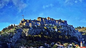
Fortress of Klis
Medieval fortress in Klis, Croatia
Distance: Approx. 6531 meters
Latitude and longitude: 43.56,16.52388889
The Klis Fortress (Croatian: Tvrđava Klis; Italian: Fortezza di Clissa) is a medieval fortress situated above the village of Klis, near Split, Croatia. From its origin as a small stronghold built by the ancient Illyrian tribe Dalmatae, to a role as royal castle and seat of many Croatian kings, to its final development as a large fortress during the Ottoman wars in Europe, Klis Fortress has guarded the frontier, being lost and re-conquered several times throughout its 2,000-year history. Due to its location on a pass that separates the mountains Mosor and Kozjak, the fortress served as a major source of defense in Dalmatia, especially against the Ottoman Empire.

Stadion Hrvatski vitezovi
Football stadium in Dugopolje, Croatia
Distance: Approx. 2102 meters
Latitude and longitude: 43.58805556,16.57416667
Stadion Hrvatski vitezovi (English: Croatian Knights Stadium) is a football stadium in Dugopolje, near the city of Split in southern Croatia. The stadium has a capacity of 5,200 and is home to the second-level side NK Dugopolje. The stadium was officially opened on 22 July 2009, with a friendly game between Dugopolje and Hajduk Split.

Konjsko Tunnel
Tunnel in Croatia
Distance: Approx. 9045 meters
Latitude and longitude: 43.59583333,16.48833333
The Konjsko Tunnel is located between Vučevica and Dugopolje interchanges of the A1 motorway, in the central Dalmatia region of Croatia. The tunnel tubes vary in length, and are 1,262 metres (4,140 ft) and 1,122 metres (3,681 ft) long respectively. The tunnel tubes were completed simultaneously.

Bisko
Village in Croatia
Distance: Approx. 6701 meters
Latitude and longitude: 43.58,16.68194444
Bisko is a village in Croatia. It is connected by the D220 highway.
Žrnovnica
Place in Split-Dalmatia County, Croatia
Distance: Approx. 7518 meters
Latitude and longitude: 43.52111111,16.55888889
Žrnovnica is a settlement (naselje) in Croatia, administratively part of the city of Split. The population is 3,222 (census 2011).

Siege of Klis
1536–37 Ottoman victory in Croatia
Distance: Approx. 6531 meters
Latitude and longitude: 43.56,16.52388889
The siege of Klis or Battle of Klis (Croatian: Opsada Klisa, Bitka kod Klisa, Turkish: Klise Kuşatması) was a siege of Klis Fortress in the Kingdom of Croatia within Habsburg monarchy. The siege of the fortress, which lasted for more than two decades, and the final battle near Klis in 1537, were fought as a part of the Ottoman–Habsburg wars between the defending Croatian–Habsburg forces under the leadership of Croatian feudal lord Petar Kružić, and the attacking Ottoman army under the leadership of the Ottoman general Murat-beg Tardić. After the decisive Ottoman victory at the Battle of Krbava Field in 1493, and especially after the Battle of Mohács in 1526, the Croats continued defending themselves against the Ottoman attacks.

Vranjača Cave
Distance: Approx. 4587 meters
Latitude and longitude: 43.5622,16.6487
Vranjača Cave (pronounced [vraɲatʃa]; Croatian: Špilja Vranjača) is a karst cave in Croatia, on the northern slopes of the Mosor mountain near the village of Kotlenice, some 18 miles inland from Split. The cave is a Geomorphological Natural Monument of Croatia, and a significant site of Neolithic culture and post-diluvial fauna. The cave was formed in rudist limestone as a ponor of an ancient stream.
Prisoje, Croatia
Place
Distance: Approx. 5205 meters
Latitude and longitude: 43.62805556,16.61083333
Prisoje is a village in Dicmo, Croatia. In the 2011 census, it had 643 inhabitants.

Kučine, Croatia
Place
Distance: Approx. 7851 meters
Latitude and longitude: 43.5325,16.52972222
Kučine is a village near Solin, Croatia. In the 2011 census, it had 974 inhabitants.

Rižinice monastery
Historic site in Klis, Croatia
Distance: Approx. 8623 meters
Latitude and longitude: 43.5549,16.4988
Rupotine is an archeological site near Solin, Croatia, which is believed by Croatian archaeologists to be the site of medieval Rižinice monastery. It is considered one of the most significant early medieval Croatian archeological sites due to the inscription of duke Trpimir "PRO DUCE TREPIME(ro)" which was found here.
Weather in this IP's area
clear sky
10 Celsius
9 Celsius
10 Celsius
10 Celsius
1021 hPa
53 %
1021 hPa
985 hPa
10000 meters
2.9 m/s
2.45 m/s
37 degree
6 %
06:41:20
16:33:52