Country:
Region:
City:
Latitude and Longitude:
Time Zone:
Postal Code:
IP information under different IP Channel
ip-api
Country
Region
City
ASN
Time Zone
ISP
Blacklist
Proxy
Latitude
Longitude
Postal
Route
Luminati
Country
Region
14
City
osijek
ASN
Time Zone
Europe/Zagreb
ISP
Telemach Hrvatska d.o.o.
Latitude
Longitude
Postal
IPinfo
Country
Region
City
ASN
Time Zone
ISP
Blacklist
Proxy
Latitude
Longitude
Postal
Route
db-ip
Country
Region
City
ASN
Time Zone
ISP
Blacklist
Proxy
Latitude
Longitude
Postal
Route
ipdata
Country
Region
City
ASN
Time Zone
ISP
Blacklist
Proxy
Latitude
Longitude
Postal
Route
Popular places and events near this IP address

Osijek
City in Osijek-Baranja, Croatia
Distance: Approx. 920 meters
Latitude and longitude: 45.55555556,18.69444444
Osijek (Croatian pronunciation: [ôsijeːk] ) is the fourth-largest city in Croatia, with a population of 96,848 in 2021. It is the largest city and the economic and cultural centre of the eastern Croatian region of Slavonia, as well as the administrative centre of Osijek-Baranja County. Osijek is on the right bank of the Drava River, 25 km (16 mi) upstream of its confluence with the Danube, at an elevation of 94 m (308 ft).

Virovitica County
Historic county of the Kingdom of Croatia-Slavonia
Distance: Approx. 965 meters
Latitude and longitude: 45.55,18.68333333
Virovitica County (Croatian: Virovitička županija; Hungarian: Verőce vármegye) was an administrative subdivision (županija) of the Medieval Kingdom of Croatia, the Kingdom of Slavonia and the Kingdom of Croatia-Slavonia. Slavonia was an autonomous kingdom within both Croatia and Hungary, themselves within the Habsburg Monarchy/Austrian Empire; Croatia-Slavonia, its successor, was an autonomous kingdom within the Lands of the Crown of Saint Stephen (Transleithania), the Hungarian part of Austria-Hungary. Its territory is now in eastern Croatia.

Gradski Vrt Stadium
Football stadium in Osijek, Croatia
Distance: Approx. 262 meters
Latitude and longitude: 45.545,18.69583333
Gradski vrt Stadium (Croatian: Stadion Gradski vrt, lit. 'City Garden Stadium') is a multi-use stadium in Osijek, Croatia. It is located in the Gradski vrt neighbourhood in Novi grad city district. With a capacity of 18,856, it has been best known as the home ground of Croatian football club NK Osijek.

Gradski vrt Hall
Sport venue in Osijek
Distance: Approx. 296 meters
Latitude and longitude: 45.54472222,18.69416667
Gradski vrt Hall is a multi-purpose indoor arena in Osijek, Croatia. The complex is used mostly for handball and basketball matches. The complex has 7 main halls, two of them with spectator seats, bigger one capacity of 3,538 (4,438 basketball configuration) and a smaller one 1,770, there are two more smaller halls for fighting sports training.
Jug Sport Hall
Indoor arena in Osijek, Croatia
Distance: Approx. 1246 meters
Latitude and longitude: 45.54277778,18.70972222
Jug Sport Hall (Croatian: Športska dvorana Jug) is an indoor arena in the Jug II city district of Osijek, Croatia. It is located in city district of Jug I. It has a capacity of 1,250 seats. It was opened in 2005.

Osijek railway station
Railway station in Osijek, Croatia
Distance: Approx. 1098 meters
Latitude and longitude: 45.5529,18.6835
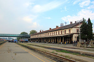
Osijek railway station (Croatian: Željeznički kolodvor Osijek) is the principal railway station in Osijek and one of the larger stations in Croatia. It is located on Lavoslav Ružička Square in the centre of Osijek.
Osijek bus station
Main bus station in Osijek, Croatia
Distance: Approx. 1349 meters
Latitude and longitude: 45.55325,18.68002778
Osijek bus station (Croatian: Autobusni kolodvor Osijek) is the principal bus station in Osijek, Croatia. It was opened in 2011 and it is the most modern station in Croatia.
Industrijska četvrt
City district of Osijek in Croatia
Distance: Approx. 990 meters
Latitude and longitude: 45.55,18.683
Industrijska četvrt is a city district of Osijek, Croatia. It has 6,920 inhabitants distributed in 2,000 households. Day of the city district is on 1 May, on feast of Saint Joseph the Worker.

Museum of Fine Arts, Osijek
Gallery in Osijek, Croatia
Distance: Approx. 1237 meters
Latitude and longitude: 45.5583099,18.6972713
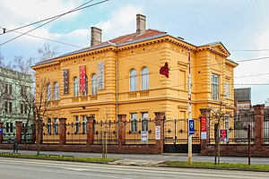
The Museum of Fine Arts (Croatian: Muzej likovnih umjetnosti) is an art museum in Osijek, Croatia. It was established in 1954.

Eurodom Osijek
Business and cultural center in Osijek, Croatia
Distance: Approx. 900 meters
Latitude and longitude: 45.555386,18.694807
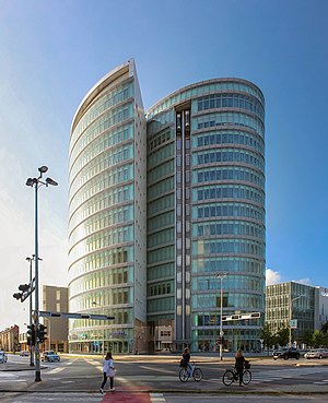
Eurodom is a business, shopping and cultural center in Osijek, Croatia. It is named after Eurodom company, which was established in 2002. The whole complex is 85,000 m2 (910,000 sq ft) and it consists of three buildings, two are business towers and the third is a shopping mall and cultural center.

III Gymnasium Osijek
Public high school in Osijek, Croatia
Distance: Approx. 1365 meters
Latitude and longitude: 45.55955556,18.69475
III Gymnasium Osijek (Croatian: III. gimnazija Osijek) is a high school in Osijek, Croatia.
Franjo Krežma Concert Hall
Distance: Approx. 965 meters
Latitude and longitude: 45.55596694,18.69511889
Franjo Krežma Concert Hall (Croatian: Koncertna dvorana Franjo Krežma) is the first concert hall in Osijek, situated inside Cultural Center Osijek. The size of the hall itself is 1000 m2 with a 400 seat capacity. It is the most modern concert hall in Croatia and the second largest concert hall in the country after Vatroslav Lisinski Concert Hall in Zagreb.
Weather in this IP's area
mist
4 Celsius
3 Celsius
4 Celsius
5 Celsius
1027 hPa
93 %
1027 hPa
1016 hPa
3000 meters
1.54 m/s
10 degree
100 %
06:37:47
16:20:39

