Country:
Region:
City:
Latitude and Longitude:
Time Zone:
Postal Code:
IP information under different IP Channel
ip-api
Country
Region
City
ASN
Time Zone
ISP
Blacklist
Proxy
Latitude
Longitude
Postal
Route
Luminati
Country
Region
30
City
kyiv
ASN
Time Zone
Europe/Kyiv
ISP
PrJSC VF UKRAINE
Latitude
Longitude
Postal
IPinfo
Country
Region
City
ASN
Time Zone
ISP
Blacklist
Proxy
Latitude
Longitude
Postal
Route
db-ip
Country
Region
City
ASN
Time Zone
ISP
Blacklist
Proxy
Latitude
Longitude
Postal
Route
ipdata
Country
Region
City
ASN
Time Zone
ISP
Blacklist
Proxy
Latitude
Longitude
Postal
Route
Popular places and events near this IP address

Kyiv Funicular
Distance: Approx. 475 meters
Latitude and longitude: 50.45777778,30.52361111
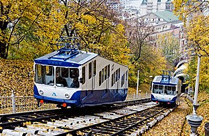
The Kyiv Funicular (Ukrainian: Київський фунікулер) is a steep slope railroad on Kyiv Hills that serves the city of Kyiv, connecting the historic Uppertown, and the lower commercial neighborhood of Podil through the steep Volodymyrska Hill overseeing the Dnieper River. The line consists of only two stations and is operated by the Kyiv city community enterprise Kyivpastrans.

Postal Square
Historic square in Kyiv, Ukraine
Distance: Approx. 409 meters
Latitude and longitude: 50.45944444,30.525
Poshtova Square (Ukrainian: Поштова площа, translit.: Poshtova Ploshcha, pronounced [pɔʃˈtɔʋɐ ˈpɫɔʃt͡ʃɐ], literally: Postal Square) in Kyiv, the capital of Ukraine, is one of the oldest historic squares of the city. Archaeological findings are dated back to the 4th century. A crossing of several historic streets such as Saint Volodymyr Descent, Borychiv Descent and Sahaydachny Street, the square is located at the Dnipro riverfront right next to the Kyiv River Port.

Kyiv River Port
Port in Ukraine
Distance: Approx. 271 meters
Latitude and longitude: 50.45916667,30.52694444
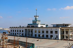
The Kyiv River Port (Ukrainian: Київський річковий порт; translit. Kyivskyi richkovyi port) is the main river port of Kyiv, located on the right bank of the Dnieper River in the Podil neighborhood of the city. The port has an own fleet that serves as a shipping company.
Borychiv Descent
Distance: Approx. 503 meters
Latitude and longitude: 50.458814,30.523319
Borychiv Descent (Ukrainian: Боричів узвіз, translit.: Borychiv uzviz) is a historic descent in the historical and merchant quarter of Kyiv, the Podil (Podol) neighbourhood. It is located near the Poshtova Square. Its legendary name, Borichev Descent, is derived from either the name of a wealthy Kyivan who lived there at the turn of the 19th century, or from the word borych/biruch (Ukrainian: борич/бірюч), which means a herald and customs officer serving the Kyiv Prince in the Middle Ages.
Poshtova Ploshcha (Kyiv Metro)
Kyiv Metro Station
Distance: Approx. 397 meters
Latitude and longitude: 50.45916667,30.525
Poshtova Ploshcha (Ukrainian: Поштова площа, ) is a station on Kyiv Metro's Obolonsko–Teremkivska Line. The station was opened on 17 December 1976, and is named after Kyiv's Poshtova Square (Post Square) near the Dnieper's embankment in the historic Podil neighbourhood. It was designed by A.S. Krushynskyi, T.A. Tselykovska, I.L. Maslenkov, and V.S. Bohdanovskyi.

National Philharmonic of Ukraine
Distance: Approx. 538 meters
Latitude and longitude: 50.45333333,30.52833333
The National Philharmonic of Ukraine (Ukrainian: Національна Філармонія України), often referred to as Kyiv Philharmonic and National Philharmonic, is a complex of two adjacent concert halls in the Khreshchatyi Park in Kyiv, Ukraine. Formerly the Merchant's House, the building's use for musical performances is associated with the Philharmonic Society, established by Mykola Lysenko. The historic building was built at the end of the 19th century.

Arch of Freedom of the Ukrainian People
Monument in Kyiv
Distance: Approx. 396 meters
Latitude and longitude: 50.45444444,30.53
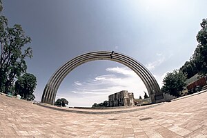
The Arch of Freedom of the Ukrainian People (Ukrainian: Арка свободи українського народу, romanized: Arka svobody ukrainskoho narodu), formerly known as Peoples' Friendship Arch (Ukrainian: Арка дружби народів, romanized: Arka druzhby narodiv) is a monument in Kyiv, the capital of Ukraine. It was opened on 7 November 1982, amidst the celebration of the 1,500th Anniversary of Kyiv, to commemorate the 60th Anniversary of the USSR and the "reunification of Ukraine with Russia in 1654" (the Pereiaslav Agreement as it was known in the Soviet Union). The sculpture under the arch, which depicted a Ukrainian worker and a Russian worker standing together, was dismantled in April 2022 amidst the Russian invasion of Ukraine.

Saint Volodymyr Hill
Park in Kyiv, Ukraine
Distance: Approx. 315 meters
Latitude and longitude: 50.45677222,30.5263
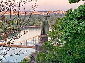
Volodymyrska Hill or Saint Volodymyr Hill (Ukrainian: Володимирська гірка, "Volodymyrska hirka") is a large 10.6 hectares (0.106 km2) park located on the steep right-bank of the Dnipro River in central Kyiv, the capital of Ukraine. Its most famous and prominent landmark is the Monument to Prince Volodymyr. The monument, with its prominent location and overlooking the scenic panorama of the left-bank of Kyiv, has since become one of the symbols of Kyiv, often depicted in paintings and photographic works of the city.

Monument to Magdeburg Rights (Kyiv)
Monument in Kyiv, Ukraine
Distance: Approx. 229 meters
Latitude and longitude: 50.45600833,30.529475
The Monument to the Magdeburg Rights (Ukrainian: Пам'ятник Маґдебурзькому праву) is a monument commemorating the return to Kyiv of its Magdeburg rights, which granted its right to self-government. It is located in Podil Raion, Kyiv, at the foothills of the former Mykhailo Hill, next to the Shore Highway. It is considered to be the city's oldest monument.

Monument to Prince Volodymyr
1853 monument in Kyiv
Distance: Approx. 335 meters
Latitude and longitude: 50.4564,30.5263
Monument to Prince Volodymyr, is a monument in Kyiv, dedicated to the Grand Prince of Kyiv Volodymyr the Great, built in 1853. It is located on Volodymyrska Hill, the steep right bank of the Dnipro. It is the oldest sculptural monument, a dominating feature of the Dnipro banks, and one of the city's symbols.

Kyiv River Station
Distance: Approx. 271 meters
Latitude and longitude: 50.45916667,30.52694444
Kyiv River Station is the main river port of Kyiv, located on the right bank of the Dnieper in Podil in the historical part of the city.

Bridge over Saint Volodymyr Descent
Bridge in Kyiv, Ukraine
Distance: Approx. 346 meters
Latitude and longitude: 50.45517,30.52827
Pedestrian and cycling bridge over Saint Volodymyr Descent (Ukrainian: Пішохідно-велосипедний міст через Володимирський узвіз, romanized: Pishokhidno-velosypednyi mist cherez Volodomyrskyi uzviz), also known as Klitschko Glass Bridge (Скляний міст Кличка, Sklianyi mist Klychka), is a bridge connecting two parks in Kyiv, Ukraine—the Saint Volodymyr Hill and Khreshchatyi Park—over the street Saint Volodymyr Descent. It is used by pedal cycles and pedestrians only. Built over five months at a cost of 275 million hryvnia, the bridge was opened by Kyiv mayor Vitali Klitschko on 25 May 2019.
Weather in this IP's area
overcast clouds
3 Celsius
0 Celsius
3 Celsius
6 Celsius
1008 hPa
91 %
1008 hPa
996 hPa
10000 meters
3.45 m/s
9.05 m/s
229 degree
91 %
07:17:36
16:08:54

