Country:
 Slovenia
Region:
City:
Latitude and Longitude:
Time Zone:
Postal Code:
IP information under different IP Channel
ip-api
Country
Region
City
ASN
Time Zone
ISP
Blacklist
Proxy
Latitude
Longitude
Postal
Route
IPinfo
Country
Region
City
ASN
Time Zone
ISP
Blacklist
Proxy
Latitude
Longitude
Postal
Route
MaxMind
Country
Region
City
ASN
Time Zone
ISP
Blacklist
Proxy
Latitude
Longitude
Postal
Route
Luminati
Country
SIRegion
102
City
radovljica
ASN
Time Zone
Europe/Ljubljana
ISP
Telemach UG d.o.o.
Latitude
Longitude
Postal
db-ip
Country
Region
City
ASN
Time Zone
ISP
Blacklist
Proxy
Latitude
Longitude
Postal
Route
ipdata
Country
Region
City
ASN
Time Zone
ISP
Blacklist
Proxy
Latitude
Longitude
Postal
Route
Popular places and events near this IP address

Radovljica
Town in Upper Carniola, Slovenia
Distance: Approx. 607 meters
Latitude and longitude: 46.34251667,14.17207778
Radovljica (pronounced [ɾaˈdoːu̯ljitsa] ; German: Radmannsdorf) is a town in the Upper Carniola region of northern Slovenia. It is the administrative seat of the Municipality of Radovljica.

Lesce
Place in Upper Carniola, Slovenia
Distance: Approx. 2036 meters
Latitude and longitude: 46.36,14.15638889
Lesce (pronounced [lɛˈstsɛ]) is a town in the Municipality of Radovljica in the Upper Carniola region of Slovenia. It is an industrial and tourist centre. It is one of the earliest-mentioned settlements in the region, first noted in a document from 1004 together with Bled and Bohinj.

Lesce-Bled Airport
Airport in Lesce
Distance: Approx. 1232 meters
Latitude and longitude: 46.35833333,14.17805556
Lesce-Bled Airport (ICAO: LJBL) (Slovene: Letališče Lesce) is located in Lesce, in the northwest part of Slovenia, only a few "air" kilometers between airports in Slovenia and Austria. Road connections with Austria and Italy are possible via the A2 motorway. The operator of the airport is the Public Commercial Institution ALC Lesce-Bled, established by the nearby municipality of Radovljica.

Sava Dolinka
River in Slovenia
Distance: Approx. 1600 meters
Latitude and longitude: 46.3442,14.1553
The Sava Dolinka is a headwater of the Sava River in northwestern Slovenia. The 45 kilometres (28 mi) long Sava Dolinka starts as Nadiža Creek in the Planica Valley under Mount Zadnja Ponca in the Julian Alps, at an elevation of 1222 m, close to the Italian border. The stream goes underground soon after its source and breaks out again after 5 km at an elevation of 842 m in Zelenci, near Kranjska Gora.
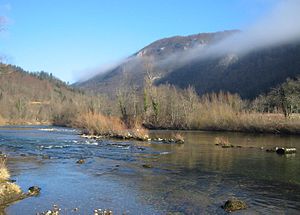
Sava Bohinjka
River in Slovenia
Distance: Approx. 1600 meters
Latitude and longitude: 46.3442,14.1553
The Sava Bohinjka is a headwater of the Sava River in northwestern Slovenia. At 41 kilometres (25 mi) in length, it is the shorter of the two headwaters that become the Sava River in the town of Radovljica, the other being the 45 km (28 mi)-long Sava Dolinka.

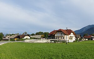
Gorica, Radovljica
Place in Upper Carniola, Slovenia
Distance: Approx. 1733 meters
Latitude and longitude: 46.34566944,14.19801389
Gorica (pronounced [ɡɔˈɾiːtsa]) is a settlement in the Municipality of Radovljica in the Upper Carniola region of Slovenia.

Lancovo
Place in Upper Carniola, Slovenia
Distance: Approx. 2019 meters
Latitude and longitude: 46.3328,14.16001667
Lancovo (pronounced [ˈlaːntsɔʋɔ]) is a settlement on the right bank of the Sava River, opposite Radovljica in the Upper Carniola region of Slovenia.

Nova Vas pri Lescah
Place in Upper Carniola, Slovenia
Distance: Approx. 1585 meters
Latitude and longitude: 46.359,14.18755556
Nova Vas pri Lescah (pronounced [ˈnɔːʋa ˈʋaːs pɾi lɛˈstsax]; Slovene: Nova vas pri Lescah) is a settlement near Lesce in the Municipality of Radovljica in the Upper Carniola region of Slovenia.

Vrbnje
Place in Upper Carniola, Slovenia
Distance: Approx. 1262 meters
Latitude and longitude: 46.35178889,14.19074167
Vrbnje (pronounced [ˈʋəɾbnjɛ], German: Werbnach) is a settlement in the Municipality of Radovljica in the Upper Carniola region of Slovenia.
Zapuže, Radovljica
Place in Upper Carniola, Slovenia
Distance: Approx. 1536 meters
Latitude and longitude: 46.35443611,14.19280278
Zapuže (pronounced [ˈzaːpuʒɛ]) is a settlement in the Municipality of Radovljica in the Upper Carniola region of Slovenia.

Municipality of Radovljica
Municipality of Slovenia
Distance: Approx. 745 meters
Latitude and longitude: 46.35,14.16666667
The Municipality of Radovljica (pronounced [ɾaˈdoːu̯ljitsa] ; Slovene: Občina Radovljica) is a municipality in the Upper Carniola region of northern Slovenia. The administrative seat of the municipality is the town of Radovljica.

Lesce-Bled railway station
Railway station in Upper Carniola, Slovenia
Distance: Approx. 1968 meters
Latitude and longitude: 46.36027778,14.15805556
Lesce-Bled railway station (Slovene: Železniška postaja Lesce Bled) is a railway station in the town of Lesce in the Upper Carniola region of northwestern Slovenia. It also serves the nearby town of Bled about 4 km away. It is operated by Slovenian Railways (SŽ).
Weather in this IP's area
broken clouds
11 Celsius
10 Celsius
10 Celsius
11 Celsius
1020 hPa
96 %
1020 hPa
962 hPa
10000 meters
1.99 m/s
3.06 m/s
352 degree
77 %
06:46:40
19:07:27