Country:
 Great Britain
Region:
City:
Latitude and Longitude:
Time Zone:
Postal Code:
IP information under different IP Channel
ip-api
Country
Region
City
ASN
Time Zone
ISP
Blacklist
Proxy
Latitude
Longitude
Postal
Route
IPinfo
Country
Region
City
ASN
Time Zone
ISP
Blacklist
Proxy
Latitude
Longitude
Postal
Route
MaxMind
Country
Region
City
ASN
Time Zone
ISP
Blacklist
Proxy
Latitude
Longitude
Postal
Route
Luminati
Country
GBRegion
eng
City
hackney
ASN
Time Zone
Europe/London
ISP
CloudCoCo Connect Limited
Latitude
Longitude
Postal
db-ip
Country
Region
City
ASN
Time Zone
ISP
Blacklist
Proxy
Latitude
Longitude
Postal
Route
ipdata
Country
Region
City
ASN
Time Zone
ISP
Blacklist
Proxy
Latitude
Longitude
Postal
Route
Popular places and events near this IP address

London Fields
Human settlement in England
Distance: Approx. 58 meters
Latitude and longitude: 51.541104,-0.059545
London Fields is a park in Hackney, London, although the name also refers to the immediate area in Hackney surrounding it and London Fields station. It is common land adjoining the Hackney Central area of the London Borough of Hackney. The park covers an area of 12.65 hectares (31.3 acres), and includes sporting and recreation facilities.

London Fields railway station
London Overground station
Distance: Approx. 189 meters
Latitude and longitude: 51.5407,-0.0577
London Fields is a London Overground station on the Lea Valley Lines, serving the district of London Fields in the London Borough of Hackney, east London. It is 2 miles 35 chains (3.9 km) down-line from London Liverpool Street and is situated between Cambridge Heath and Hackney Downs. Its three-letter station code is LOF and it is in Travelcard zone 2.

Miniscule of Sound
Distance: Approx. 170 meters
Latitude and longitude: 51.54286389,-0.06119167
The Miniscule of Sound is a performance given in a small wooden structure described as "The World's Smallest Niteclub". It was devised in Hackney, London, in 1998 as a parody of established superclubs, with the name referring to the Ministry of Sound. This led to representatives from the Ministry of Sound considering legal action, though in following communications an amicable agreement was reached.

Hackney South and Shoreditch (UK Parliament constituency)
Parliamentary constituency in the United Kingdom, 1974 onwards
Distance: Approx. 167 meters
Latitude and longitude: 51.54,-0.06
Hackney South and Shoreditch is a constituency represented in the House of Commons of the UK Parliament since 2005 by Meg Hillier of Labour Co-op.

Hackney Central
Human settlement in England
Distance: Approx. 206 meters
Latitude and longitude: 51.543307,-0.059486
Hackney Central is a sub-district of Hackney in the London Borough of Hackney in London, England and is four miles (6.4 km) northeast of Charing Cross. The Hackney Central area is focused on Mare Street and the retail areas to the north of it including Narrow Way and surrounding local area around Hackney Downs railway station. As such it extends north from Regent's Canal (with Bethnal Green), takes in most of Broadway Market and London Fields, and follows each side of Mare Street till it terminates in the vicinity of Hackney Central railway station.
Dalston bus garage
Distance: Approx. 369 meters
Latitude and longitude: 51.53916667,-0.06388889
Dalston bus garage was a bus depot in Dalston, London, England. It was opened by Motor Bus Co in 1906, passing with the business to Vanguard Motors in 1907, who in turn sold out to the London General Omnibus Company in 1908. It was built on the site of a former cavalry barracks.

Festifeel
Distance: Approx. 344 meters
Latitude and longitude: 51.5387,-0.058
Festifeel is an annual music festival held to raise money for breast cancer awareness. The festival is organised by the English breast cancer charity CoppaFeel. It describes itself as "Britain's only boutique music festival with boobs in mind".

The Dolphin, Hackney
Grade listed public house in east London
Distance: Approx. 330 meters
Latitude and longitude: 51.5398,-0.0562
The Dolphin is a Grade II listed public house and nightclub at 165 Mare Street, Hackney Central in the London Borough of Hackney, London. It is on the Campaign for Real Ale's National Inventory of Historic Pub Interiors. It was built about 1850.
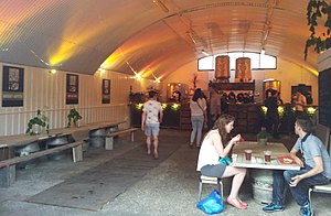
London Fields Brewery
Distance: Approx. 344 meters
Latitude and longitude: 51.5387,-0.058
London Fields Brewery was a brewery in the London Fields area of the London Borough of Hackney, London. It was founded in 2011 with significant success riding the wave of new craft beers, though by December 2014 the company had fallen into trouble following the arrest of co-founder Julian de Vere Whiteway-Wilkinson, on suspicion of tax evasion. In 2017, London Fields Brewery was purchased in a joint-venture by Brooklyn Brewery and Carlsberg UK with plans to bring brewing back onsite.

Hackney Museum
Local museum in London, England
Distance: Approx. 447 meters
Latitude and longitude: 51.54450833,-0.055825
Hackney Museum is a local history museum located in the London Borough of Hackney. Amongst other aspects of the Hackney area, the museum explores the history of immigration.
Hackney, London
Human settlement in England
Distance: Approx. 184 meters
Latitude and longitude: 51.543,-0.059
Hackney is a district in East London, England, forming around two-thirds of the area of the modern London Borough of Hackney, to which it gives its name. It is 4 miles (6.4 km) northeast of Charing Cross and includes part of the Queen Elizabeth Olympic Park. Historically it was within the county of Middlesex.
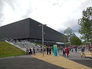
London School of Architecture
Architecture school in London, England
Distance: Approx. 369 meters
Latitude and longitude: 51.5388,-0.057
The London School of Architecture, known as the LSA, is a small independent higher education provider based in London. It is England's first independent school of architecture since the Architectural Association opened in 1847.
Weather in this IP's area
broken clouds
12 Celsius
12 Celsius
11 Celsius
14 Celsius
1027 hPa
91 %
1027 hPa
1025 hPa
10000 meters
3.09 m/s
340 degree
75 %
06:37:15
19:12:56