Country:
 Great Britain
Region:
City:
Latitude and Longitude:
Time Zone:
Postal Code:
IP information under different IP Channel
ip-api
Country
Region
City
ASN
Time Zone
ISP
Blacklist
Proxy
Latitude
Longitude
Postal
Route
IPinfo
Country
Region
City
ASN
Time Zone
ISP
Blacklist
Proxy
Latitude
Longitude
Postal
Route
MaxMind
Country
Region
City
ASN
Time Zone
ISP
Blacklist
Proxy
Latitude
Longitude
Postal
Route
Luminati
Country
GBASN
Time Zone
Europe/London
ISP
CloudCoCo Connect Limited
Latitude
Longitude
Postal
db-ip
Country
Region
City
ASN
Time Zone
ISP
Blacklist
Proxy
Latitude
Longitude
Postal
Route
ipdata
Country
Region
City
ASN
Time Zone
ISP
Blacklist
Proxy
Latitude
Longitude
Postal
Route
Popular places and events near this IP address

Bournemouth
Town in Dorset, England
Distance: Approx. 377 meters
Latitude and longitude: 50.72001,-1.87995
Bournemouth ( BORN-məth) is a coastal resort town in the Bournemouth, Christchurch and Poole unitary authority area, in the ceremonial county of Dorset, England. The 2021 census built-up area had a population of 196,455, making it the largest town in Dorset. Previously an uninhabited and rarely-visited heathland, other than by occasional fishermen and smugglers, a health resort was founded in the area by Lewis Tregonwell in 1810.

South East Dorset conurbation
Population centre in Southern England
Distance: Approx. 365 meters
Latitude and longitude: 50.72,-1.87
The South East Dorset conurbation (also known as the South Dorset conurbation, Poole-Bournemouth urban area and Bournemouth urban area) is a multi-centred conurbation on the south coast of Dorset in England.

The Square, Bournemouth
Public square
Distance: Approx. 358 meters
Latitude and longitude: 50.72032,-1.87981
The Square is a public square in Bournemouth Town Centre that marks the centre of Bournemouth, England. The Square separates the Central Gardens from the Lower Gardens.
Bournemouth (UK Parliament constituency)
Distance: Approx. 307 meters
Latitude and longitude: 50.722,-1.879
Bournemouth was a former United Kingdom Parliamentary constituency. The seat was created in 1918 and existed until it was abolished and split into two new seats in 1950. During the constituency's existence it was the most south-westerly seat in Hampshire (although the county boundary between Dorset and Hampshire was redrawn in 1974 so the town was transferred to Dorset).
Westover, Hampshire
Distance: Approx. 307 meters
Latitude and longitude: 50.722,-1.879
Westover, Hampshire, is the ancient manor, now in Dorset, over which much of modern Bournemouth has developed. This area of land marked a historic boundary between Celtic and Saxon civilisations, which found expression as the county boundary between Hampshire to the east and Dorset to the west. Geographically detached parts of the manor (for example the tithings of Longham and North Ashley) may have resulted from the post-Civil War breakup of estates formerly belonging to the Lords Arundell of Wardour.

St Peter's Church, Bournemouth
Church in Dorset, England
Distance: Approx. 80 meters
Latitude and longitude: 50.7205,-1.8755
St Peter's Church is a Church of England parish church located in the centre of Bournemouth, Dorset, England. It is a Grade I listed building classed as a 'major parish church', and was completed in 1879 to a design by George Edmund Street as the founding mother church of Bournemouth. The building incorporates work by some of the finest Gothic Revival architects and artists, including Street, George Frederick Bodley, Ninian Comper, Arthur Blomfield and Edward Burne-Jones, with stained-glass windows and frescoes by Clayton and Bell.
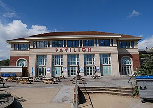
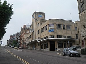
Pavilion Theatre, Bournemouth
Distance: Approx. 370 meters
Latitude and longitude: 50.71777778,-1.87472222
The Pavilion Theatre and Ballroom is a concert hall in Bournemouth. It opened in 1929 and has been redesigned several times since.

Bournemouth Community Hebrew Congregation
Historic site
Distance: Approx. 274 meters
Latitude and longitude: 50.721,-1.871
The Bournemouth Community Hebrew Congregation is an Orthodox Jewish congregation and synagogue, located in Wootton Gardens, Lansdowne, Bournemouth, Dorset, England, in the United Kingdom. The congregation was formed in 1905 and worships in the Ashkenazi rite. The rabbi of the congregation is Adrian Jesner.

Bournemouth Air Festival
Annual air show in the United Kingdom
Distance: Approx. 381 meters
Latitude and longitude: 50.72,-1.88
The Bournemouth Air Festival is an annual air show held along the coast at Bournemouth, in Dorset, England. It has featured aircraft from the Royal Air Force and the Royal Navy, as well as civil aviation displays. Since its formation in 2008, the festival claims to have entertained over ten million people.

Sacred Heart Church, Bournemouth
Church in Dorset, England
Distance: Approx. 269 meters
Latitude and longitude: 50.7211,-1.8787
The Catholic Church of the Sacred Heart, or Sacred Heart Church, is a Roman Catholic church in the seaside resort of Bournemouth, England. Located on Albert Road close to the town centre, it was the first Roman Catholic church built in Bournemouth and is part of the Diocese of Portsmouth. It has been designated a Grade II listed building by English Heritage.

Bournemouth Town Centre
Distance: Approx. 381 meters
Latitude and longitude: 50.72,-1.88
Bournemouth Town Centre is an area of Bournemouth, Dorset. The town centre is the central business district and is located near the coast between West Cliff and East Cliff.
Bournemouth Daily Echo building
Historic landmark in Bournemouth, England
Distance: Approx. 243 meters
Latitude and longitude: 50.7214,-1.8783
The Bournemouth Daily Echo building is a historic landmark and Grade II listed building in Bournemouth, England. The office building is located on Richmond Hill next door to the Sacred Heart Church.
Weather in this IP's area
scattered clouds
14 Celsius
14 Celsius
13 Celsius
15 Celsius
1026 hPa
94 %
1026 hPa
1023 hPa
10000 meters
1.03 m/s
340 degree
40 %
06:44:59
19:19:44