Country:
Region:
City:
Latitude and Longitude:
Time Zone:
Postal Code:
IP information under different IP Channel
ip-api
Country
Region
City
ASN
Time Zone
ISP
Blacklist
Proxy
Latitude
Longitude
Postal
Route
Luminati
Country
ASN
Time Zone
Europe/London
ISP
CloudCoCo Connect Limited
Latitude
Longitude
Postal
IPinfo
Country
Region
City
ASN
Time Zone
ISP
Blacklist
Proxy
Latitude
Longitude
Postal
Route
db-ip
Country
Region
City
ASN
Time Zone
ISP
Blacklist
Proxy
Latitude
Longitude
Postal
Route
ipdata
Country
Region
City
ASN
Time Zone
ISP
Blacklist
Proxy
Latitude
Longitude
Postal
Route
Popular places and events near this IP address

Bournemouth West (UK Parliament constituency)
Parliamentary constituency in the United Kingdom, 1950 onwards
Distance: Approx. 920 meters
Latitude and longitude: 50.717,-1.913
Bournemouth West is a parliamentary constituency in Dorset represented in the House of Commons of the UK Parliament since 2024 by Jessica Toale, a member of the Labour Party.

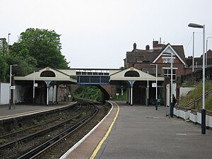
Branksome railway station
Railway station in Dorset, England
Distance: Approx. 994 meters
Latitude and longitude: 50.728,-1.919
Branksome railway station serves the Branksome and Branksome Park areas of Poole in Dorset, England. It is on the South West Main Line, 110 miles 51 chains (178.1 km) down the line from London Waterloo.

Branksome, Dorset
Human settlement in England
Distance: Approx. 621 meters
Latitude and longitude: 50.725,-1.915
Branksome () is a suburb of Poole, in the Bournemouth, Christchurch and Poole district, in the ceremonial county of Dorset, England. The area consists of residential properties and also a number of commercial and industrial areas. It borders Parkstone, another small Poole suburb, to the west and north west, Alder Hills to the north east, Branksome Park (a more affluent forested area) to the south and Westbourne (a suburb of Bournemouth, Poole's conurbation neighbour) to the east.

Westbourne, Dorset
Human settlement in England
Distance: Approx. 816 meters
Latitude and longitude: 50.719,-1.898
Westbourne is a residential and shopping area of Bournemouth, Dorset, England. It is located in between Branksome, Poole and the centre of Bournemouth, just off the A338. Poole Road, mainly full of specialised shops and small cafes, runs through the centre of Westbourne with Seamoor Road curving round bringing more shops and services.

Branksome Park
Suburb of Poole, Dorset, England
Distance: Approx. 1014 meters
Latitude and longitude: 50.718,-1.917
Branksome Park is a suburb of Poole in Dorset, which adjoins Branksome, Dorset. The area covers approximately 360 acres (1.5 km2), mostly occupied by housing, and includes Branksome Chine which leads to the award-winning blue-flagged beaches of Poole.

Bournemouth West railway station
Former railway station in Dorset, England
Distance: Approx. 914 meters
Latitude and longitude: 50.72218,-1.8937
Bournemouth West was a railway station in Bournemouth, Dorset, England which closed in 1965.
Talbot Heath School
Girls' school in Bournemouth, Dorset, England
Distance: Approx. 854 meters
Latitude and longitude: 50.731,-1.901
Talbot Heath School is a selective, private day and boarding school for girls aged 3–18 located in Talbot Woods, Bournemouth, Dorset, England. The school was founded as Bournemouth High School in 1886 by founding headmistress Mary Broad. Talbot Heath was originally a Church of England School.

Royal Victoria Hospital, Bournemouth
Hospital in Dorset, England
Distance: Approx. 953 meters
Latitude and longitude: 50.7207,-1.8939
The Royal Victoria Hospital was a hospital situated on two sites in Bournemouth, England. The primary site was in Boscombe but for a period of time it was merged with a Westbourne site. The Westbourne site was the first named Royal Victoria Hospital of the two but the name was applied to both sites after merger in 1911.

Bournemouth Traincare Depot
Railway maintenance depot in Bournemouth, England
Distance: Approx. 253 meters
Latitude and longitude: 50.7259,-1.9085
Bournemouth Traincare Depot is a traction maintenance depot located in Bournemouth, South West England. The depot is situated on a spur off the South West Main Line and is to the east of Branksome station.

Alum Chine
Distance: Approx. 1209 meters
Latitude and longitude: 50.714,-1.9
Alum Chine is the largest chine in Bournemouth, England. The gorge was crossed by a suspension bridge by the early part of the twentieth century.

St Aldhelm's Church, Poole
Church in Poole, UK
Distance: Approx. 880 meters
Latitude and longitude: 50.7258,-1.9185
St Aldhelm's Church is a Grade II* listed Gothic Revival Anglican church in the Branksome area of Poole, Dorset, England. It is dedicated to Saint Aldhelm, the abbot of Malmesbury Abbey who became first Bishop of Sherborne in the early 8th century.

Bourne Valley Viaducts
Bridges in Dorset, UK
Distance: Approx. 762 meters
Latitude and longitude: 50.729305,-1.913341
The Bourne Valley Viaducts are two Victorian brick railway viaducts in Bournemouth and Poole, England. One bridge is disused while the other carries a section of the South West Main Line from London to Weymouth between Bournemouth railway station and Branksome railway station.
Weather in this IP's area
light intensity drizzle
12 Celsius
12 Celsius
12 Celsius
13 Celsius
1029 hPa
90 %
1029 hPa
1023 hPa
7000 meters
3.09 m/s
60 degree
75 %
07:01:17
16:41:00