Country:
 Great Britain
Region:
City:
Latitude and Longitude:
Time Zone:
Postal Code:
IP information under different IP Channel
ip-api
Country
Region
City
ASN
Time Zone
ISP
Blacklist
Proxy
Latitude
Longitude
Postal
Route
IPinfo
Country
Region
City
ASN
Time Zone
ISP
Blacklist
Proxy
Latitude
Longitude
Postal
Route
MaxMind
Country
Region
City
ASN
Time Zone
ISP
Blacklist
Proxy
Latitude
Longitude
Postal
Route
Luminati
Country
GBRegion
eng
City
bournemouth
ASN
Time Zone
Europe/London
ISP
CloudCoCo Connect Limited
Latitude
Longitude
Postal
db-ip
Country
Region
City
ASN
Time Zone
ISP
Blacklist
Proxy
Latitude
Longitude
Postal
Route
ipdata
Country
Region
City
ASN
Time Zone
ISP
Blacklist
Proxy
Latitude
Longitude
Postal
Route
Popular places and events near this IP address
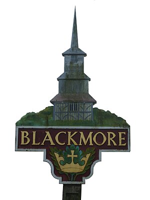
Blackmore
Village in Essex, England
Distance: Approx. 490 meters
Latitude and longitude: 51.6894,0.3266
Blackmore is a village in Essex, England. It is located approximately 3 miles (5 km) east of Chipping Ongar and 4 miles (7 km) north of Brentwood. The village is in the parish of Blackmore, Hook End and Wyatts Green in the Brentwood district and the parliamentary constituency of Brentwood & Ongar.

Doddinghurst
Human settlement in England
Distance: Approx. 3079 meters
Latitude and longitude: 51.6635,0.3043
Doddinghurst is a village and civil parish in the Borough of Brentwood, in south Essex. It is 3 miles (5 km) to the north of Brentwood.

Stondon Massey
Village in Essex, England
Distance: Approx. 2173 meters
Latitude and longitude: 51.68,0.292
Stondon Massey is a village and civil parish in the Brentwood district of Essex, England. The village is to the north of Brentwood, between Blackmore and Doddinghurst. Stondon Massey hosts an annual fete on the village green.
Blackmore, Hook End and Wyatts Green
Civil parish in Brentwood, England
Distance: Approx. 1244 meters
Latitude and longitude: 51.68,0.31
Blackmore, Hook End and Wyatts Green is a civil parish in the Brentwood borough of Essex, England. According to the 2001 census it had a population of 3,082, reducing slightly to 3,040 at the 2011 census.

Ingatestone and Fryerning
Civil parish in Brentwood, England
Distance: Approx. 3446 meters
Latitude and longitude: 51.67638889,0.36472222
Ingatestone and Fryerning is a civil parish in the Brentwood borough of Essex, England. The parish includes the villages of Ingatestone and Fryerning, and covers an area of 3,917 acres (15.85 km2).
Blackmore Priory
Priory in Essex, England
Distance: Approx. 149 meters
Latitude and longitude: 51.690355,0.317834
Blackmore Priory was a priory in Essex, England. It was established as an Augustinian Priory with a Prior and twelve Canons, who were not monks but ordained priests. They would be expected to work in the parish as well as lead a monastic life in the Priory.
Norton Heath
Human settlement in England
Distance: Approx. 2842 meters
Latitude and longitude: 51.715,0.3174
Norton Heath is a hamlet in the High Ongar civil parish, and the Epping Forest District of Essex, England. The settlement is at the northeast of the parish and on the north side of the Harlow to Chelmsford A414 road.

King Street, Essex
Human settlement in England
Distance: Approx. 2322 meters
Latitude and longitude: 51.7059,0.2987
King Street is a hamlet in the High Ongar civil parish of the Epping Forest district of Essex, England. The hamlet, a linear development along the road of King Street, is 300 yards (274 m) south from the A414 Harlow to Chelmsford road. King Street is 1.5 miles (2 km) east from the parish village of High Ongar, and less than 1 mile north from the hamlet of Nine Ashes.

Mill Green, Essex
Human settlement in England
Distance: Approx. 3521 meters
Latitude and longitude: 51.685,0.37
Mill Green is a hamlet in civil parish of Ingatestone and Fryerning, in the Brentwood district, in the English county of Essex. It is near the town of Ingatestone and the village of Fryerning. There is a wood called Millgreen Wood and a mill called Mill Green Mill.

Nine Ashes
Human settlement in England
Distance: Approx. 1625 meters
Latitude and longitude: 51.7006,0.3042
Nine Ashes is a hamlet in the civil parish of High Ongar, in the Epping Forest district of Essex, England. The hamlet, a linear development along Nine Ashes Road, is less than 1 mile south from the Harlow to Chelmsford A414 road. Nearby settlements including the village of Norton Heath and the hamlet of King Street.
Church of All Saints, Doddinghurst
Distance: Approx. 2934 meters
Latitude and longitude: 51.6673,0.2966
The Church of All Saints is a Church of England parish church in Doddinghurst, Essex. The church is a Grade I listed building.

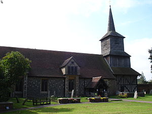
St Laurence's Church, Blackmore
Church in Essex, United Kingdom
Distance: Approx. 147 meters
Latitude and longitude: 51.69027778,0.31777778
St Laurence's Church is an Anglican church, in the village of Blackmore, Essex, England. It is a former priory church, and is noted for its wooden bell tower. It is a Grade I listed building.
Weather in this IP's area
overcast clouds
12 Celsius
11 Celsius
10 Celsius
14 Celsius
1026 hPa
93 %
1026 hPa
1017 hPa
10000 meters
2.82 m/s
6.44 m/s
356 degree
96 %
06:35:39
19:11:30