84.41.105.249 - IP Lookup: Free IP Address Lookup, Postal Code Lookup, IP Location Lookup, IP ASN, Public IP
Country:
Region:
City:
Location:
Time Zone:
Postal Code:
IP information under different IP Channel
ip-api
Country
Region
City
ASN
Time Zone
ISP
Blacklist
Proxy
Latitude
Longitude
Postal
Route
Luminati
Country
Region
160
City
slivnicaprimariboru
ASN
Time Zone
Europe/Ljubljana
ISP
SOFTNET d.o.o.
Latitude
Longitude
Postal
IPinfo
Country
Region
City
ASN
Time Zone
ISP
Blacklist
Proxy
Latitude
Longitude
Postal
Route
IP2Location
84.41.105.249Country
Region
federacija bosne i hercegovine
City
kalesija
Time Zone
Europe/Sarajevo
ISP
Language
User-Agent
Latitude
Longitude
Postal
db-ip
Country
Region
City
ASN
Time Zone
ISP
Blacklist
Proxy
Latitude
Longitude
Postal
Route
ipdata
Country
Region
City
ASN
Time Zone
ISP
Blacklist
Proxy
Latitude
Longitude
Postal
Route
Popular places and events near this IP address

Kalesija
Town and municipality in Federation of Bosnia and Herzegovina, Bosnia and Herzegovina
Distance: Approx. 3497 meters
Latitude and longitude: 44.45,18.86666667
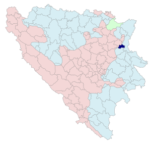
Kalesija (Serbian Cyrillic: Калесија) is a town and municipality located in the Tuzla Canton of the Federation of Bosnia and Herzegovina, an entity of Bosnia and Herzegovina. It is located in northeastern Bosnia and Herzegovina, east of Tuzla. As of 2013, the town has a population of 2,039 inhabitants, while the municipality has 33,053 inhabitants.

Osmaci
Village and municipality
Distance: Approx. 4115 meters
Latitude and longitude: 44.40138889,18.9175
Osmaci (Serbian Cyrillic: Осмаци) is a town and municipality in Republika Srpska, Bosnia and Herzegovina. As of 2013, it has a population of 6,016 inhabitants. There is also a small, uninhabited, part of Osmaci that is in Kalesija municipality.

Operation Bøllebank
1994 Bosnian War confrontation
Distance: Approx. 2760 meters
Latitude and longitude: 44.4425,18.87305556
The Operation Bøllebank (English: Operation Bully Bashing) is the name given to the military confrontation between Bosnian Serb military forces and Danish, Norwegian, and Swedish combat units composing the United Nations Protection Force's (UNPROFOR) Nordic Battalion (NORDBAT 2), outside of the city of Tuzla on 29 April 1994. When trying to relieve Swedish forces at the Tango 2 observation post past the village of Kalesija, Danish forces of the Jydske Dragonregiment were ambushed by the Bosnian Serb Šekovići brigade. The ambush was dispersed by backup UN forces retaliating with heavy fire from Danish Snow Leopard tanks in two separate firefights.
Dubnica (Kalesija)
Village in Federation of Bosnia and Herzegovina, Bosnia and Herzegovina
Distance: Approx. 4313 meters
Latitude and longitude: 44.4697,18.8767
Dubnica (Serbian Cyrillic: Дубница) is a village in the municipality of Kalesija, Bosnia and Herzegovina.
Memići (Kalesija)
Village in Federation of Bosnia and Herzegovina, Bosnia and Herzegovina
Distance: Approx. 2031 meters
Latitude and longitude: 44.4269,18.9278
Memići is a village in the municipality of Kalesija, Bosnia and Herzegovina.
Prnjavor (Kalesija)
Village in Federation of Bosnia and Herzegovina, Bosnia and Herzegovina
Distance: Approx. 3395 meters
Latitude and longitude: 44.4475,18.8667
Prnjavor is a village in the municipality of Kalesija, Bosnia and Herzegovina.
Staro Selo (Kalesija)
Village in Federation of Bosnia and Herzegovina, Bosnia and Herzegovina
Distance: Approx. 3535 meters
Latitude and longitude: 44.43472222,18.95138889
Staro Selo (Cyrillic: Старо Село) is a village in the municipality of Kalesija, Bosnia and Herzegovina.
Zelina (Kalesija)
Village in Federation of Bosnia and Herzegovina, Bosnia and Herzegovina
Distance: Approx. 4006 meters
Latitude and longitude: 44.4089,18.8767
Zelina is a village in the municipalities of Osmaci (Republika Srpska) and Kalesija, Bosnia and Herzegovina.
Zolje
Village in Federation of Bosnia and Herzegovina, Bosnia and Herzegovina
Distance: Approx. 2311 meters
Latitude and longitude: 44.4564364,18.8948751
Zolje is a village in the municipality of Kalesija, Bosnia and Herzegovina.
Zukići (Kalesija)
Village in Federation of Bosnia and Herzegovina, Bosnia and Herzegovina
Distance: Approx. 3548 meters
Latitude and longitude: 44.45777778,18.94166667
Zukići (Cyrillic: Зукићи) is a village in the municipality of Kalesija, Bosnia and Herzegovina.
Neovisni Radio Feral
Bosnian radio station
Distance: Approx. 3497 meters
Latitude and longitude: 44.45,18.86666667
Neovisni Radio Feral or Nezavisni Radio Feral is a Bosnian local commercial radio station, broadcasting from Kalesija, Bosnia and Herzegovina. This radio station broadcasts a variety of programs such as music, talk show and local news. According to media reports, one of the most listened radio stations in BiH is Radio Feral Kalesija.
Kalesija Selo
Village in Federation of Bosnia and Herzegovina, Bosnia and Herzegovina
Distance: Approx. 1156 meters
Latitude and longitude: 44.4422214,18.8940811
Kalesija Selo is a village in the municipality of Kalesija, Bosnia and Herzegovina.
Weather in this IP's area
mist
-0 Celsius
-0 Celsius
-0 Celsius
-0 Celsius
1022 hPa
100 %
1022 hPa
985 hPa
5000 meters
1.03 m/s
75 %