Country:
Region:
City:
Latitude and Longitude:
Time Zone:
Postal Code:
IP information under different IP Channel
ip-api
Country
Region
City
ASN
Time Zone
ISP
Blacklist
Proxy
Latitude
Longitude
Postal
Route
Luminati
Country
Region
56
City
sliema
ASN
Time Zone
Europe/Malta
ISP
Melita Limited
Latitude
Longitude
Postal
IPinfo
Country
Region
City
ASN
Time Zone
ISP
Blacklist
Proxy
Latitude
Longitude
Postal
Route
db-ip
Country
Region
City
ASN
Time Zone
ISP
Blacklist
Proxy
Latitude
Longitude
Postal
Route
ipdata
Country
Region
City
ASN
Time Zone
ISP
Blacklist
Proxy
Latitude
Longitude
Postal
Route
Popular places and events near this IP address

Ta' Xbiex
Local council in Central Region, Malta
Distance: Approx. 445 meters
Latitude and longitude: 35.89916667,14.49805556
Ta' Xbiex (Maltese pronunciation: [tɐʒˈbɪːʃ]) is a locality and Local Council in the Eastern Region of Malta with a population of 2,148 (estimated 2019). It is part of a small headland within the Marsamxett Harbour, right between the villages of Msida and Gżira.

Gżira
Local council in Central Region, Malta
Distance: Approx. 287 meters
Latitude and longitude: 35.905,14.49444444
Gżira (Maltese: Il-Gżira) is a town in the Central Region of Malta. It is located between Msida and Sliema, also bordering on Ta' Xbiex. It has a population of 11,699 as of January 2019.

Manoel Island
Island of Malta
Distance: Approx. 528 meters
Latitude and longitude: 35.904,14.502
Manoel Island (Maltese: Il-Gżira Manoel), formerly known as Bishop's Island (Maltese: Il-Gżira tal-Isqof, Italian: Isola del Vescovo) or the Isolotto, is a small island which forms part of the municipality of Gżira in Marsamxett Harbour, Malta. It is named after the Portuguese Grand Master António Manoel de Vilhena, who built a fort on the island in the 1720s. The island was in turn renamed after the fort.
Church of the Holy Trinity, Sliema
Church in Sliema, Malta
Distance: Approx. 775 meters
Latitude and longitude: 35.90986111,14.496
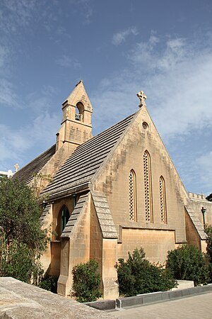
The Church of the Holy Trinity is a Church of England church in Sliema, Malta which was built to resemble an English village church and opened in 1866.

Carmelite Parish Church, Gżira
Church in Gżira, Malta
Distance: Approx. 270 meters
Latitude and longitude: 35.90497222,14.49475
The Parish Church of Our Lady of Mount Carmel or simply known as the Carmelite Church is a Doric Roman Catholic parish church located in Gżira, Malta.

Bible Baptist Church, Gżira
Church in Gżira, Malta
Distance: Approx. 784 meters
Latitude and longitude: 35.90841667,14.49088889
The Bible Baptist Church is a Baptist church located in Gżira, Malta.

The Green House, Sliema
Historic townhouse in Sliema, Malta
Distance: Approx. 782 meters
Latitude and longitude: 35.90875,14.50111111
The Green House (Maltese: Id-Dar il-Ħadra) was a late 19th-century vernacular townhouse in Sliema, Malta. The historic residence was an icon in the area, situated at the end of St Mary Street of which name of street derives from the niche on the façade of the building. The façade was notably characterized by its dark green colour which had made it a noticeable landmark.

Orpheum Theatre (Malta)
Building in Gżira, Malta
Distance: Approx. 303 meters
Latitude and longitude: 35.90555556,14.49555556
The Orpheum Theatre is a building situated in Gżira, Malta. It was designed in 1932 by the Maltese architect Harold J. Borg (1908–1981), then still in his early twenties, to the design of Art Nouveau with Spanish features. The theatre was commissioned by Felix Gerada, a developer who lived between Malta and Detroit (hence the initials FG on the façade) on land he purchased from the Marquis Desain and was built to serve as a movie theatre.

Muscats Motors
Showroom in Gżira, Malta
Distance: Approx. 482 meters
Latitude and longitude: 35.90147222,14.49125
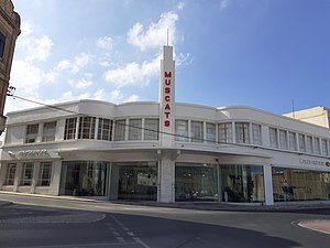
The Muscats Motors showroom, belonging to a car dealership of the same name, is a building located in Gżira, Malta. It was designed by Joseph Colombo in the Streamline Moderne style, and it is the only building of that style in Malta. It was constructed in around 1945 on the site of an earlier garage which had been destroyed in World War II. Today, the building is in good condition and it still serves its original purpose as a showroom.

Villino Ellul
House (now offices) in Ta' Xbiex, Malta
Distance: Approx. 222 meters
Latitude and longitude: 35.90122222,14.49497222
Villino Ellul or Villa Ellul is a Modernist villa in Ta' Xbiex, Malta. It was designed and built in the 1930s by the architect Salvatore Ellul as his personal villa, and it was one of the first Modernist buildings to be built on the island. The building has been restored and converted into offices, and it is now known as Dixcart House.

Wembley ice-cream factory
Factory in Gżira, Malta
Distance: Approx. 355 meters
Latitude and longitude: 35.905,14.49333333
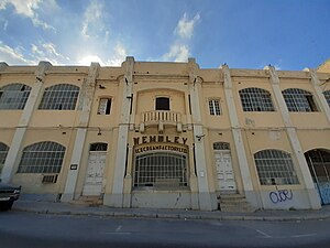
The Wembley ice-cream factory in Triq D'Argens, Gżira, Malta was completed in 1937 by architect Antonio Grech Dimech. It was built for industrialist Luke V. Gauci, who in 1937 introduced pasteurized and pre-packed ice-cream in Malta under the brand name of Wembleys. Edward Said described the factory as one of “the best examples of pre-war industrial architecture in Malta” due to the symmetrical façade which includes subtle features reflecting the eclectic style used in dwellings at the time.

Chapel of St Anthony of Padua, Fort Manoel
Church in Gżira, Malta
Distance: Approx. 795 meters
Latitude and longitude: 35.90316667,14.50511111
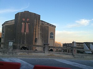
The Chapel of St Anthony of Padua (Maltese: Kappella ta' Sant'Antnin ta' Padova) is a Roman Catholic chapel located in Fort Manoel on Manoel Island in Gżira, Malta. It was completed in 1727 as an integral part of the fort, and it was partially destroyed by aerial bombardment in 1942 during World War II. The chapel was reconstructed as part of a restoration project and it was completed in 2009.
Weather in this IP's area
few clouds
18 Celsius
19 Celsius
18 Celsius
20 Celsius
1024 hPa
82 %
1024 hPa
1023 hPa
10000 meters
3.09 m/s
260 degree
20 %
06:27:32
17:03:36
