84.255.36.133 - IP Lookup: Free IP Address Lookup, Postal Code Lookup, IP Location Lookup, IP ASN, Public IP
Country:
Region:
City:
Location:
Time Zone:
Postal Code:
IP information under different IP Channel
ip-api
Country
Region
City
ASN
Time Zone
ISP
Blacklist
Proxy
Latitude
Longitude
Postal
Route
Luminati
Country
Region
04
City
birkirkara
ASN
Time Zone
Europe/Malta
ISP
Melita Limited
Latitude
Longitude
Postal
IPinfo
Country
Region
City
ASN
Time Zone
ISP
Blacklist
Proxy
Latitude
Longitude
Postal
Route
IP2Location
84.255.36.133Country
Region
iklin
City
l-iklin
Time Zone
Europe/Malta
ISP
Language
User-Agent
Latitude
Longitude
Postal
db-ip
Country
Region
City
ASN
Time Zone
ISP
Blacklist
Proxy
Latitude
Longitude
Postal
Route
ipdata
Country
Region
City
ASN
Time Zone
ISP
Blacklist
Proxy
Latitude
Longitude
Postal
Route
Popular places and events near this IP address
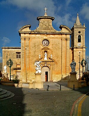
Balzan
Local council in Central Region, Malta
Distance: Approx. 677 meters
Latitude and longitude: 35.89805556,14.45333333
Balzan (Maltese: Ħal Balzan) is a municipality in the Central Region of Malta, one of the so-called three villages, together with Attard and Lija. The village originally consisted of a group of small dwellings and farms but eventually grew, becoming a parish in the 17th century. As of 2022, the town registered a population of 4,821 inhabitants.

Lija
Local council in Eastern Region, Malta
Distance: Approx. 698 meters
Latitude and longitude: 35.90138889,14.44722222
Lija (Maltese: Ħal Lija) is a small village in the Eastern Region of Malta. It forms part of the Three villages of Malta, along with Attard and Balzan. Lija has a baroque parish church and seven other small chapels.
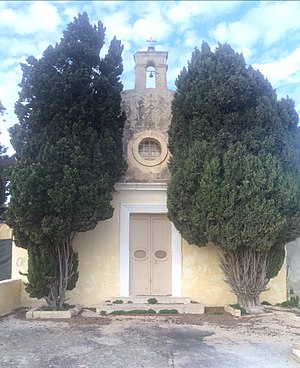
Iklin
Local council in Central Region, Malta
Distance: Approx. 23 meters
Latitude and longitude: 35.90416667,14.45444444
Iklin (Maltese: L-Iklin) is a village in the Central Region of Malta, with a population of 3,247 as at 2021. Iklin was established in the mid-20th century; however some archaeological sites and a medieval chapel, named as St. Michael Chapel, are proof to earlier settlements.

Villa Francia
Palace in Lija, Malta
Distance: Approx. 840 meters
Latitude and longitude: 35.90313,14.44496
Villa Francia, initially named Palazzo Francia, then named Villa Preziosi, and officially known as Palazzo Francia and Francia Estate, is an 18th-century palace in Lija, Malta. The palace was built circa 1757, by Francesco Preziosi, with baroque architecture that gave a sense of pride and power to noble people at the time. The first ambitious owner became bankrupt with the expenses of the palace, to make it an outstanding and incomparable building, and because of this he was pressured to sell his possession by the Order of St.
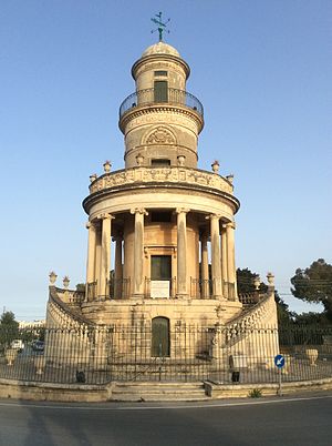
Lija Belvedere Tower
Building in Lija, Malta
Distance: Approx. 548 meters
Latitude and longitude: 35.902,14.4487
The Lija Belvedere Tower (Maltese: Torri Belvedere) is a belvedere in Lija, Malta. It was built in the 19th century as a folly within a private garden, and it is now located on a roundabout.

Villa Parisio
16th century villa in Lija, Malta
Distance: Approx. 555 meters
Latitude and longitude: 35.903818,14.448058
Villa Parisio is a villa in Lija, Malta. It was built in the 16th century by the Muscati family, and eventually passed into the hands of the Parisio Muscati, de Piro and Strickland families. It is currently the seat of The Strickland Foundation, and also the home of Robert Hornyold-Strickland and his family for his lifetime.

French invasion of Malta
1798 invasion, part of the Mediterranean campaign
Distance: Approx. 593 meters
Latitude and longitude: 35.9,14.45
The French invasion of Malta (Maltese: Invażjoni Franċiża ta' Malta, French: Débarquement Français à Malte) was the successful invasion of the islands of Malta and Gozo, then ruled by the Order of St. John, by the French First Republic led by Napoleon Bonaparte in June 1798 as part of the Mediterranean campaign of the French Revolutionary Wars. The initial landings were met with some resistance from both the Order and the Maltese militia, but in less than a day the French had taken control of the entire Maltese archipelago except for the well-fortified harbour area that included the capital Valletta.

Our Saviour's Church, Lija
Church in Lija, Malta
Distance: Approx. 743 meters
Latitude and longitude: 35.90161111,14.44655556
Our Saviour's Church or more formally The Parish Church of the Transfiguration of Jesus is a Roman Catholic Baroque Parish church located in the village of Lija, Malta.
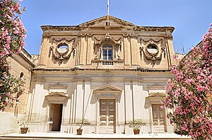
Church of St Alphonse Liguori, Birkirkara
Church in Birkirkara, Malta
Distance: Approx. 868 meters
Latitude and longitude: 35.89708333,14.45838889
The Church of St Alphonse Liguori (Maltese: Il-Knisja ta' San Alfons Liguori) is a Roman Catholic church in Birkirkara, Malta. It was operated by the Discalced Carmelites, and was dedicated to Saint Alphonsus Maria de' Liguori. The church is currently used as a meeting hall known as Our Lady of Mount Carmel Hall (Maltese: Sala Madonna tal-Karmnu).
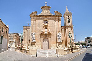
Annunciation Church, Balzan
Church in Balzan, Malta
Distance: Approx. 650 meters
Latitude and longitude: 35.8987,14.451464
The Parish Church of the Annunciation is one of the Roman Catholic parish churches located in the village of Balzan, Malta.

Ta' Ganu Windmill
18th-century structure in Malta
Distance: Approx. 489 meters
Latitude and longitude: 35.89993,14.4559
Ta' Ganu Windmill (also known as Tal-Maħlut Windmill) is an eighteenth century windmill in Birkirkara, Malta. It was built in 1724 by the António Manoel de Vilhena Foundation. "Maħlut", the alternative name also used for it historically, is the Maltese word for a mixture of wheat and hops used for making bread.

Sanctuary of Our Lady of Tal-Ħerba
Church in Birkirkara, Malta
Distance: Approx. 1016 meters
Latitude and longitude: 35.90122222,14.46488889
The Sanctuary of Our Lady of Tal-Ħerba (Maltese: Santwarju tal-Madonna tal-Ħerba) is a Roman Catholic church in Birkirkara, Malta, dedicated to the Nativity of Mary. It was constructed at various stages between the early 17th century and the 1920s, on the site of an earlier church which had existed since at least 1575. Pope Pius X granted a Pontifical decree of coronation to the venerated Marian image on 13 February 1910 signed via Cardinal Mariano Rampolla y Tindaro, and notarized by Cardinal Angelo di Pietro.
Weather in this IP's area
few clouds
11 Celsius
10 Celsius
11 Celsius
13 Celsius
1010 hPa
66 %
1010 hPa
1002 hPa
10000 meters
8.75 m/s
310 degree
20 %