Country:
Region:
City:
Latitude and Longitude:
Time Zone:
Postal Code:
IP information under different IP Channel
ip-api
Country
Region
City
ASN
Time Zone
ISP
Blacklist
Proxy
Latitude
Longitude
Postal
Route
Luminati
Country
ASN
Time Zone
Europe/Berlin
ISP
Arelion Sweden AB
Latitude
Longitude
Postal
IPinfo
Country
Region
City
ASN
Time Zone
ISP
Blacklist
Proxy
Latitude
Longitude
Postal
Route
db-ip
Country
Region
City
ASN
Time Zone
ISP
Blacklist
Proxy
Latitude
Longitude
Postal
Route
ipdata
Country
Region
City
ASN
Time Zone
ISP
Blacklist
Proxy
Latitude
Longitude
Postal
Route
Popular places and events near this IP address

Bad Oldesloe
Town in Schleswig-Holstein, Germany
Distance: Approx. 1038 meters
Latitude and longitude: 53.81166667,10.37416667
Bad Oldesloe (German pronunciation: [ˌbaːt ˈʔɔldəsˌloː]) is a town located in the northern German state of Schleswig-Holstein. It is the capital of the district of Stormarn. The area has been inhabited since Mesolithic times.

Pölitz
Municipality in Schleswig-Holstein, Germany
Distance: Approx. 2247 meters
Latitude and longitude: 53.78333333,10.38333333
Pölitz is a municipality in the district of Stormarn, in Schleswig-Holstein, Germany.

Nütschau Priory
Distance: Approx. 4196 meters
Latitude and longitude: 53.8225,10.32666667
Nütschau Priory (in German Kloster Nütschau or Priorat Sankt Ansgar) is a house of the Benedictine Order located at Travenbrück near Bad Oldesloe, Stormarn, Schleswig-Holstein in Germany.
Bad Oldesloe-Land
Collective municipality in Schleswig-Holstein, Germany
Distance: Approx. 1038 meters
Latitude and longitude: 53.81166667,10.37416667
Bad Oldesloe-Land is an Amt ("collective municipality") in the district of Stormarn, in Schleswig-Holstein, Germany. It is situated around Bad Oldesloe, which is the seat of the Amt, but not part of it.

Rethwisch, Stormarn
Municipality in Schleswig-Holstein, Germany
Distance: Approx. 4610 meters
Latitude and longitude: 53.78277778,10.4425
Rethwisch is a municipality in the district of Stormarn, in Schleswig-Holstein, Germany.

Feldhorst
Municipality in Schleswig-Holstein, Germany
Distance: Approx. 6009 meters
Latitude and longitude: 53.85305556,10.41805556
Feldhorst is a municipality in the district of Stormarn, in Schleswig-Holstein, Germany.

Meddewade
Municipality in Schleswig-Holstein, Germany
Distance: Approx. 3870 meters
Latitude and longitude: 53.80972222,10.43972222
Meddewade is a municipality in the district of Stormarn, in Schleswig-Holstein, Germany.

Rümpel
Municipality in Schleswig-Holstein, Germany
Distance: Approx. 3068 meters
Latitude and longitude: 53.78333333,10.35
Rümpel is a municipality in the district of Stormarn, in Schleswig-Holstein, Germany.

Barnitz (river)
River in Schleswig-Holstein, Germany
Distance: Approx. 1220 meters
Latitude and longitude: 53.7958,10.3686
Barnitz is a river of Schleswig-Holstein, Germany. It flows into the Beste southwest of Bad Oldesloe.

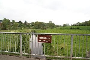
Norderbeste
River in Schleswig-Holstein, Germany
Distance: Approx. 4374 meters
Latitude and longitude: 53.7869,10.3215
Norderbeste is a river of Schleswig-Holstein, Germany. It flows into the Beste southwest of Bad Oldesloe.

Bad Oldesloe station
Railway station in Bad Oldesloe, Germany
Distance: Approx. 217 meters
Latitude and longitude: 53.805369,10.382718
Bad Oldesloe station is the most important station of the town of Bad Oldesloe in the German state of Schleswig-Holstein. DB Station&Service assigns it to category 2. It is located on the Lübeck–Hamburg railway, which was opened in 1865.

Beste (river)
River in Schleswig-Holstein, Germany
Distance: Approx. 728 meters
Latitude and longitude: 53.8095,10.3774
Beste is a river of Schleswig-Holstein, Germany. It flows into the Trave in Bad Oldesloe.
Weather in this IP's area
overcast clouds
9 Celsius
7 Celsius
8 Celsius
10 Celsius
1022 hPa
93 %
1022 hPa
1020 hPa
10000 meters
5.13 m/s
10.55 m/s
254 degree
100 %
07:46:00
16:20:28