Country:
 USA
USARegion:
City:
Latitude and Longitude:
Time Zone:
Postal Code:
IP information under different IP Channel
ip-api
Country
Region
City
ASN
Time Zone
ISP
Blacklist
Proxy
Latitude
Longitude
Postal
Route
IPinfo
Country
Region
City
ASN
Time Zone
ISP
Blacklist
Proxy
Latitude
Longitude
Postal
Route
MaxMind
Country
Region
City
ASN
Time Zone
ISP
Blacklist
Proxy
Latitude
Longitude
Postal
Route
Luminati
Country
USRegion
az
City
phoenix
ASN
Time Zone
America/Phoenix
ISP
iNES GROUP SRL
Latitude
Longitude
Postal
db-ip
Country
Region
City
ASN
Time Zone
ISP
Blacklist
Proxy
Latitude
Longitude
Postal
Route
ipdata
Country
Region
City
ASN
Time Zone
ISP
Blacklist
Proxy
Latitude
Longitude
Postal
Route
Popular places and events near this IP address

Sandra Day O'Connor United States Courthouse
Federal courthouse in Phoenix, Arizona
Distance: Approx. 562 meters
Latitude and longitude: 33.44777778,-112.08055556
The Sandra Day O'Connor United States Courthouse is a courthouse at 401 West Washington Street in Phoenix, Arizona. Pursuant to Pub. L.Tooltip Public Law (United States) 106–166 (text) (PDF), enacted by the United States Congress, it is named after Sandra Day O'Connor, who served as an Associate Justice of the Supreme Court of the United States from September 21, 1981, to January 31, 2006.

Union Station (Phoenix, Arizona)
Historic railway station
Distance: Approx. 807 meters
Latitude and longitude: 33.44416667,-112.07888889
Phoenix Union Station is a former train station at 401 South 4th Avenue in downtown Phoenix, Arizona, United States. From 1971 to 1996 it was an Amtrak station. Until 1971, it was a railroad stop for the Santa Fe and Southern Pacific Railroads.
Arizona Supreme Court
Highest court in the U.S. state of Arizona
Distance: Approx. 548 meters
Latitude and longitude: 33.4475,-112.0925
The Arizona Supreme Court is the state supreme court of the U.S. state of Arizona. Sitting in the Supreme Court building in downtown Phoenix, the court consists of a chief justice, a vice chief justice, and five associate justices. Each justice is appointed by the governor of Arizona from a list recommended by a bipartisan commission.

9/11 Memorial (Arizona)
State memorial to the September 11 attacks
Distance: Approx. 682 meters
Latitude and longitude: 33.44861111,-112.09381944
The 9/11 Memorial in Arizona is a state memorial to the events and aftermath of the September 11 attacks, located at the Wesley Bolin Memorial Plaza near the State Capitol in Phoenix, Arizona. The monument is a circular plan with a flat inclined metal ring. The ring was inscribed with written statements by cutting each letter through the metal, thus allowing sunlight to project the statements onto the concrete base of the monument.

Arizona Financial Theatre
Performance venue in Phoenix, Arizona
Distance: Approx. 701 meters
Latitude and longitude: 33.44861111,-112.07916667
The Arizona Financial Theatre (formerly known as the Dodge Theatre, the Comerica Theatre and the Arizona Federal Theatre) is a multi-use theatre in Downtown Phoenix, Arizona. The venue seats 5,000 people.
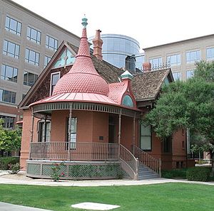
Evans House (Phoenix, Arizona)
Historic house in Arizona, United States
Distance: Approx. 95 meters
Latitude and longitude: 33.44833333,-112.08638889
The Evans House was built in 1893 by Doctor John M. Evans in Phoenix, Arizona. The 1+1⁄2-story brick residence has an unusual onion dome over the front entrance, rising from the semicircular front porch. The ground floor has seven rooms and was used as a residence, while the upper floor served as Dr.

Polly Rosenbaum Building
United States historic place
Distance: Approx. 512 meters
Latitude and longitude: 33.44861111,-112.09194444
The Polly Rosenbaum Building, formerly the El Zaribah Shrine Auditorium, is a building in Phoenix, Arizona, at the corner of 15th Avenue and Washington Street, that was built in 1921. The 18,000-square-foot (1,700 m2) building formerly housed the Arizona Mining and Mineral Museum. The building was completed in 1921 as a home for the activities of the El Zariabah Shrine unit, a local Shriners organization that had been formed in 1896.
Arizona Mining and Mineral Museum
Former museum in Phoenix
Distance: Approx. 505 meters
Latitude and longitude: 33.44857,-112.09188
The Arizona Mining and Mineral Museum in Phoenix, Arizona, was a museum focused on minerals and mining. Last operated by the Arizona Historical Society, a state government agency, its exhibits included more than 3,000 minerals, rocks, fossils, and artifacts related to the mining industry. The museum closed in May 2011.

First Presbyterian Church (Phoenix, Arizona)
Historic church in Arizona, United States
Distance: Approx. 816 meters
Latitude and longitude: 33.45055556,-112.07861111
The First Presbyterian Church in Phoenix, Arizona, is a historic church designed by architect Norman F. Marsh. Located at 402 W. Monroe Street, the church was built in 1927, in the Spanish Colonial Revival style. It was added to the National Register of Historic Places in 1993.

Phoenix Carnegie Library and Library Park
United States historic place
Distance: Approx. 45 meters
Latitude and longitude: 33.4475,-112.08611111
The Phoenix Carnegie Library and Library Park, now known as the Carnegie Center, is a historic site in Phoenix, Arizona. Completed in 1908, it was listed on the National Register of Historic Places in 1974.
Dunbar School (Phoenix, Arizona)
United States historic place
Distance: Approx. 812 meters
Latitude and longitude: 33.440443,-112.084408
Dunbar Elementary School (also known as Dunbar School) is an elementary school in Phoenix, Arizona that was once segregated.

The Van Buren
Music venue in Phoenix, Arizona
Distance: Approx. 775 meters
Latitude and longitude: 33.45106,-112.07943
The Van Buren is a music venue located in Downtown Phoenix, Arizona. The venue sits on the southwest corner of Van Buren St. and 4th Ave.
Weather in this IP's area
scattered clouds
33 Celsius
31 Celsius
31 Celsius
34 Celsius
1011 hPa
28 %
1011 hPa
975 hPa
10000 meters
5.66 m/s
70 degree
40 %
06:07:38
18:44:22